Gym nearby John Harris Fitness Donaupark Linz
Austria
Gym nearby John Harris Fitness Donaupark Linz
John Harris Fitness Donaupark Linz
Untere Donaulände 21-25, Linz Österreich
contacts phone
:
+43
Latitude:
48.3141752
, Longitude:
14.2994572
read more
nearest Gym
849 m
Practiceyoga
Prager Straße 16, Linz
Gym
read more
921 m
Gabriele Honauer Yoga
Stefan-Fechter-Weg 1, Linz
Gym
read more
927 m
health medizinisches training am Krankenhaus der Elisabethinen Linz GmbH
Museumstraße 31, Linz
Gym
read more
927 m
Linz
Museumstraße 31, Linz
Gym
read more
928 m
Yoga - Verein 77
Stefan-Fechter-Weg 5, Linz
Gym
read more
928 m
Yoga-Danter
Fechterweg 5, Linz
Gym
read more
1.017 km
Poledance & Sports Linz
Fabrikstraße 2, Linz
Gym
read more
1.028 km
health medizinisches training am Krankenhaus der Elisabethinen Linz GmbH
Eisenhandstraße 4-6, Linz
Gym
read more
1.143 km
Kanupolo Linz
Hafenviertel 4020, Linz
Gym
read more
1.147 km
M.A.N.D.U. Urfahr
Blütenstraße 20, Linz
Gym
read more
1.222 km
HappyFit Premium
4 4020, Dametzstraße 2-4, Linz
Gym
read more
1.276 km
Mrs.Sporty Club Linz Zentrum
Hauptplatz 4, Linz
Gym
read more
1.276 km
Ashtanga Yoga Linz
Hauptplatz 4, Linz
Gym
read more
1.289 km
Slender-you
Blütenstraße 2, Linz
Gym
read more
1.331 km
FOLLOW • your workout Linz
Hauptstraße 54, Linz
Gym
read more
1.414 km
Hypoxistudio Dr. Michaela Sendlhofer
Promenade 6, Linz
Gym
read more
1.422 km
Mrs.Sporty Club Linz-Urfahr
Hauptstraße 83-85, Linz
Gym
read more
1.426 km
CrossFit Stahlbox
Industriezeile 47, Linz
Gym
read more
1.541 km
Slender You Figursalon
Mozartstraße 12-14, Linz
Gym
read more
1.623 km
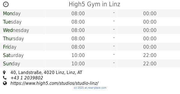
High5 Gym
Landstraße 40, Linz
Gym
read more
1.658 km
Yogaraum Linz: Yoga im Herzen von Linz
Dinghoferstraße 36, Linz
Gym
read more
1.819 km
Yoga in Daily Life
Waltherstraße 26, Linz
Gym
read more
1.83 km
Fitness studio Mühlviertel
Leonfeldner Straße 77, Linz
Gym
read more
2.054 km
yogalounge
Landstraße 84, Linz
Gym
read more
2.113 km
HappyFit Premium
Further Straße 10, Linz
Gym
read more
📑
all categories
Accounting
Administrative area level 1
Administrative area level 2
Airport
Amusement park
Aquarium
Art gallery
Atm
Bakery
Bank
Bar
Beauty salon
Bicycle store
Book store
Bowling alley
Bus station
Cafe
Campground
Car dealer
Car rental
Car repair
Car wash
Casino
Cemetery
Church
City hall
Clothing store
Colloquial area
Convenience store
Country
Courthouse
Dentist
Department store
Doctor
Electrician
Electronics store
Embassy
Finance
Fire station
Florist
Food
Funeral home
Furniture store
Gas station
General contractor
Grocery or supermarket
Gym
Hair care
Hardware store
Health
Hindu Temple
Home goods store
Hospital
Insurance agency
Jewelry store
Laundry
Lawyer
Library
Light rail station
Liquor store
Local government office
Locality
Locksmith
Lodging
Meal delivery
Meal takeaway
Mosque
Movie rental
Movie theater
Moving company
Museum
Natural feature
Neighborhood
Night club
Painter
Park
Parking
Pet store
Pharmacy
Physiotherapist
Place of worship
Plumber
Point of interest
Police
Political
Post office
Premise
Real estate agency
Restaurant
Roofing contractor
Route
Rv park, camping
School
Shoe store
Shopping mall
Spa
Stadium
Storage
Store
Subpremise
Subway station
Supermarket
Synagogue
Taxi stand
Train station
Transit station
Travel agency
University
Veterinary care
Zoo
administrative area level 3
sublocality level 1
↑