Lodging nearby Appartements Schirmer
Austria
Lodging nearby Appartements Schirmer
Appartements Schirmer
Rum Österreich
contacts phone
:
+43
Latitude:
47.2896681
, Longitude:
11.4553898
read more
nearest Lodging
61 m
Appartements "Karlhof"
Scheibenbichl 2, Rum
Lodging
read more
453 m
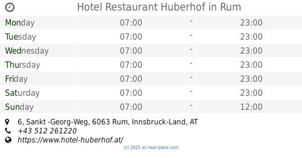
Hotel Restaurant Huberhof
Sankt -Georg-Weg 6, Rum
Lodging
read more
480 m
Haus Schreiner
Friedhofweg 6, Rum bei Innsbruck
Lodging
read more
549 m
Haus Hölzl
Langer Graben 10, Rum bei Innsbruck
Lodging
read more
550 m
Haus Danielle
Kirchgasse 3c, Rum
Lodging
read more
574 m
Haus Gfrerer
Neugasse 10, Rum bei Innsbruck
Lodging
read more
591 m
Haus Grubhofer
Dörfer Straße 37, Rum
Lodging
read more
649 m
Appartement Bacher
Wiesenweg 6, Rum
Lodging
read more
695 m
Hochrum.com
Canisiusweg 132, Rum
Lodging
read more
732 m
Appartement "Geigerhof"
Schulstraße 34, Rum
Lodging
read more
777 m
Ferienwohnungen Fuchsberger
Langer Graben 5, Rum bei Innsbruck
Lodging
read more
975 m
Gasthof Canisiusbrünnl
Murstraße 75, Rum
Lodging
read more
1.192 km
Haus Halbwirth
Gartenweg 5, Rum
Lodging
read more
1.315 km
Hotel Stangl
Kirchgasse 2, Thaur
Lodging
read more
1.34 km
Hotel-Restaurant Rumer Hof
Bundesstraße 11, Rum bei Innsbruck
Lodging
read more
1.394 km
Hotel-Gasthof Purner
Dorfplatz 5, Thaur
Lodging
read more
1.626 km
Gästehaus Sonnenheim
Stollenstraße 45, Thaur
Lodging
read more
1.626 km
Privatpension Gästehaus Sonnenheim
Stollenstraße 45, Thaur
Lodging
read more
1.718 km
Haus Langpohl
Austraße 71, Rum
Lodging
read more
1.909 km
Gasthaus Rechenhof
Rechenhofweg 100, Innsbruck
Lodging
read more
2.129 km
Winternotschlafstelle - NOSTel
Schusterbergweg 73, Innsbruck
Lodging
read more
2.312 km
Hotel Helga
Werner-von-Siemens-Straße 9, Innsbruck
Lodging
read more
2.319 km
Pension Prantner
Schützenstraße 34, Innsbruck
Lodging
read more
2.325 km
4Rest Hotel Hall
Schlöglstraße 57, Hall in Tirol
Lodging
read more
2.345 km
Griechische Restaurant El Greco Hall i.T.
Loretto-Umgebung 1, Thaur
Lodging
read more
📑
all categories
Accounting
Administrative area level 1
Administrative area level 2
Airport
Amusement park
Aquarium
Art gallery
Atm
Bakery
Bank
Bar
Beauty salon
Bicycle store
Book store
Bowling alley
Bus station
Cafe
Campground
Car dealer
Car rental
Car repair
Car wash
Casino
Cemetery
Church
City hall
Clothing store
Colloquial area
Convenience store
Country
Courthouse
Dentist
Department store
Doctor
Electrician
Electronics store
Embassy
Finance
Fire station
Florist
Food
Funeral home
Furniture store
Gas station
General contractor
Grocery or supermarket
Gym
Hair care
Hardware store
Health
Hindu Temple
Home goods store
Hospital
Insurance agency
Jewelry store
Laundry
Lawyer
Library
Light rail station
Liquor store
Local government office
Locality
Locksmith
Lodging
Meal delivery
Meal takeaway
Mosque
Movie rental
Movie theater
Moving company
Museum
Natural feature
Neighborhood
Night club
Painter
Park
Parking
Pet store
Pharmacy
Physiotherapist
Place of worship
Plumber
Point of interest
Police
Political
Post office
Premise
Real estate agency
Restaurant
Roofing contractor
Route
Rv park, camping
School
Shoe store
Shopping mall
Spa
Stadium
Storage
Store
Subpremise
Subway station
Supermarket
Synagogue
Taxi stand
Train station
Transit station
Travel agency
University
Veterinary care
Zoo
administrative area level 3
sublocality level 1
↑