Lodging nearby Gasthaus Gartlach
Austria
Lodging nearby Gasthaus Gartlach
Gasthaus Gartlach
Gartlachweg 7, Kolsassberg Austria
contacts phone
:
+43
Latitude:
47.2896768
, Longitude:
11.6228368
read more
nearest Lodging
1.269 km
Steinacher Hütte
Österreich, Wattenberg 36a, Wattenberg
Lodging
read more
1.385 km
Ferienwohnung Dax
Rettenbergstraße 16, Kolsassberg
Lodging
read more
1.43 km
Welanduz Lodge
Wattenberg 28, Wattenberg
Lodging
read more
1.707 km
Ferienwohnung Klinar
Riedweg 29, Wattens
Lodging
read more
1.744 km
Pension Unterhof
Rettenbergstraße 20, Kolsassberg
Lodging
read more
1.786 km
Chalet Sennhof
Rettenbergstraße 30, Kolsassberg
Lodging
read more
1.913 km
Stunning modern house in the alps
Birchach 15, Wattenberg
Lodging
read more
1.93 km
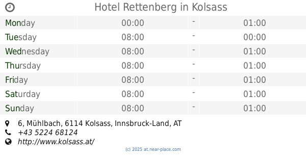
Hotel Rettenberg
Mühlbach 6, Kolsass
Lodging
read more
2.025 km
Gasthof Steixner
Kuntenweg 1, Weer
Lodging
read more
2.102 km
Haus Sonnenwinkel
7, Hochhäuserweg 1, Kolsassberg
Lodging
read more
2.114 km
Muj Hotel
Lange Gasse 21, Wattens
Lodging
read more
2.124 km
Pension Clara
Salzburger Straße 6a, Wattens
Lodging
read more
2.15 km
Hotel Alpenland
Salzburger Straße 6, Wattens
Lodging
read more
2.182 km
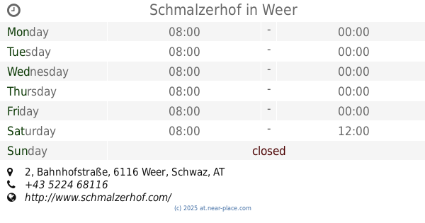
Schmalzerhof
Bahnhofstraße 2, Weer
Lodging
read more
2.228 km
Lizumer Hütte
Hnr. 105, Wattens
Lodging
read more
2.242 km
Hotel Goldener Adler
Innsbrucker Straße 1, Wattens
Lodging
read more
2.242 km
Goldener Adler
Innsbrucker Straße 1, Wattens
Lodging
read more
2.278 km
Gasthof zum Schwan
Swarovskistraße 2, Wattens
Lodging
read more
2.283 km
Gasthaus zum Schwan
Swarovskistraße 2, Wattens
Lodging
read more
2.356 km
Gasthof Neuwirt
Innsbrucker Straße 12, Wattens
Lodging
read more
2.356 km
Andreas Steinacher
Innsbrucker Straße 12, Wattens
Lodging
read more
2.492 km
Mandlhof
Dorfplatz 6, Weer
Lodging
read more
2.671 km
Familie Sponring - Maxnhagerhof
6 Högweg, Weerberg
Lodging
read more
2.852 km
Sonnenresidenz Friedheim
Högweg 3, Innerweerberg
Lodging
read more
3.082 km
Gasthaus-Pension Fritznerhof
Dorfstraße 31, Fritzens
Lodging
read more
📑
all categories
Accounting
Administrative area level 1
Administrative area level 2
Airport
Amusement park
Aquarium
Art gallery
Atm
Bakery
Bank
Bar
Beauty salon
Bicycle store
Book store
Bowling alley
Bus station
Cafe
Campground
Car dealer
Car rental
Car repair
Car wash
Casino
Cemetery
Church
City hall
Clothing store
Colloquial area
Convenience store
Country
Courthouse
Dentist
Department store
Doctor
Electrician
Electronics store
Embassy
Finance
Fire station
Florist
Food
Funeral home
Furniture store
Gas station
General contractor
Grocery or supermarket
Gym
Hair care
Hardware store
Health
Hindu Temple
Home goods store
Hospital
Insurance agency
Jewelry store
Laundry
Lawyer
Library
Light rail station
Liquor store
Local government office
Locality
Locksmith
Lodging
Meal delivery
Meal takeaway
Mosque
Movie rental
Movie theater
Moving company
Museum
Natural feature
Neighborhood
Night club
Painter
Park
Parking
Pet store
Pharmacy
Physiotherapist
Place of worship
Plumber
Point of interest
Police
Political
Post office
Premise
Real estate agency
Restaurant
Roofing contractor
Route
Rv park, camping
School
Shoe store
Shopping mall
Spa
Stadium
Storage
Store
Subpremise
Subway station
Supermarket
Synagogue
Taxi stand
Train station
Transit station
Travel agency
University
Veterinary care
Zoo
administrative area level 3
sublocality level 1
↑