Lodging nearby Gasthof Fischer
Austria
Lodging nearby Gasthof Fischer
Gasthof Fischer
Welser Straße 14, Marchtrenk Austria
contacts phone
:
+43
Latitude:
48.1912726
, Longitude:
14.108875
read more
nearest Lodging
155 m
Marchtrenk, Wohnung
Unnamed Road, 4614
Lodging
read more
179 m
Schweizer Wirtshaus & Beisl
Welser Straße 1, Marchtrenk
Lodging
read more
190 m
Sola GMBH
Bahnhofstraße 15, Marchtrenk
Lodging
read more
361 m
Renate Schmid-Steinwendner
Linzer Straße 28, Marchtrenk
Lodging
read more
672 m
Marchtrenkerhof
Linzer Straße 41, Marchtrenk
Lodging
read more
720 m
Bötscher-Bramauer
/II/8,, Paracelsusstraße 9, Marchtrenk
Lodging
read more
810 m
Vollmöbliert Nähe Wels
19, Werfelstraße, Marchtrenk
Lodging
read more
878 m
eee hotel
Kästnerstraße 6, Marchtrenk
Lodging
read more
1.333 km
Austrasse
Marchtrenk, 4614 Austrasse
Lodging
read more
1.609 km
Gasthaus Ufermann
Weißkirchner Straße 72, Marchtrenk
Lodging
read more
1.933 km
Schlafplatzl
Saturnstraße 7, Marchtrenk
Lodging
read more
1.946 km
Roland Franz Brunner
Kappernstraße 16
Lodging
read more
2.513 km
Gasthof Maxlhaid
Maxlheid 9, Wels
Lodging
read more
2.513 km
Hotel**** & Gasthof*** Maxlhaid
Maxlheid 9, Wels
Lodging
read more
2.513 km
Wels Hotel Maxlhaid
Maxlheid 9, Wels
Lodging
read more
3.404 km
Gasthaus David Jungmair
Mistelbacher Straße 84, Buchkirchen
Lodging
read more
4.139 km
Wohnen am Bauernhof bei Greti
Mühlbachstraße 148, Hörsching
Lodging
read more
4.211 km
Landgasthof Huber
Dorfstraße 4, Schleißheim
Lodging
read more
4.819 km
Pro mente Oberösterreich - Jugendwohnhaus ''Blue Box''
Gründlingerstraße 8, Hörsching
Lodging
read more
5.184 km
Mr. Mato Kljajic
Schloßstraße 4c, Wels
Lodging
read more
5.422 km
ALIF Wels
Schafwiesengasse 15a, Wels
Lodging
read more
5.44 km
ALIF Wels
Schaffwiesengasse 15, Wels
Lodging
read more
5.522 km
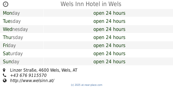
Wels Inn Hotel
104, Linzer Straße, Wels
Lodging
read more
5.693 km
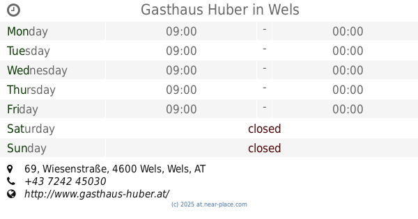
Gasthaus Huber
Wiesenstraße 69, Wels
Lodging
read more
6.314 km
3-Königshof
Allhaming 6, Allhaming
Lodging
read more
📑
all categories
Accounting
Administrative area level 1
Administrative area level 2
Airport
Amusement park
Aquarium
Art gallery
Atm
Bakery
Bank
Bar
Beauty salon
Bicycle store
Book store
Bowling alley
Bus station
Cafe
Campground
Car dealer
Car rental
Car repair
Car wash
Casino
Cemetery
Church
City hall
Clothing store
Colloquial area
Convenience store
Country
Courthouse
Dentist
Department store
Doctor
Electrician
Electronics store
Embassy
Finance
Fire station
Florist
Food
Funeral home
Furniture store
Gas station
General contractor
Grocery or supermarket
Gym
Hair care
Hardware store
Health
Hindu Temple
Home goods store
Hospital
Insurance agency
Jewelry store
Laundry
Lawyer
Library
Light rail station
Liquor store
Local government office
Locality
Locksmith
Lodging
Meal delivery
Meal takeaway
Mosque
Movie rental
Movie theater
Moving company
Museum
Natural feature
Neighborhood
Night club
Painter
Park
Parking
Pet store
Pharmacy
Physiotherapist
Place of worship
Plumber
Point of interest
Police
Political
Post office
Premise
Real estate agency
Restaurant
Roofing contractor
Route
Rv park, camping
School
Shoe store
Shopping mall
Spa
Stadium
Storage
Store
Subpremise
Subway station
Supermarket
Synagogue
Taxi stand
Train station
Transit station
Travel agency
University
Veterinary care
Zoo
administrative area level 3
sublocality level 1
↑