Lodging nearby Haus Sonnleiten
Austria
Lodging nearby Haus Sonnleiten
Haus Sonnleiten
Otterweg 1, Pill Österreich
contacts phone
:
+43
Latitude:
47.3087101
, Longitude:
11.7184759
read more
nearest Lodging
755 m
Ferienwohnungen Sumperer
Pillbergstraße 146, Pill
Lodging
read more
1.116 km
Alpenhof Hubertus
Pillbergstraße 191, Pill
Lodging
read more
1.129 km
Hotel Frieden
Pillbergstraße 200, Pill
Lodging
read more
1.244 km
Bio Hotel Grafenast
Pillbergstraße 205, Pill
Lodging
read more
1.347 km
Hotel Madlein
Weerberg
Lodging
read more
1.347 km
Madlein Hotel
Weerberg
Lodging
read more
1.521 km
Waldhütte - Chalet Auszeit
Hoferweg 35, Hochpillberg
Lodging
read more
1.7 km
Apartment Pill
Pill
Lodging
read more
2.028 km
Vitalhof Tunelhof
Außerberg 31, Weerberg in Tirol
Lodging
read more
2.028 km
Vitalhof Tunelhof - Urlaub am Bauernhof
Außerberg 31, Weerberg in Tirol
Lodging
read more
2.252 km
HECHERHAUS
Schlinglberg 11, Schwaz
Lodging
read more
2.258 km
Sportgasthof Hecher 1887m
Schlingelberg 11, Schwaz
Lodging
read more
2.317 km
Apartment Sponring
Außerberg 24, Weerberg
Lodging
read more
2.421 km
Apartment Außerberg
Außerberg 9, Weerberg
Lodging
read more
2.613 km
Hotel Garni Regina
Mitterberg 11, Weerberg
Lodging
read more
2.767 km
Familie Knoll - Ferienwohnungen Sennhof
Mitterberg 29, Weerberg
Lodging
read more
2.767 km
Bauernhof-Sennhof
Mitterberg 29, Weerberg
Lodging
read more
2.891 km
Gästehaus Anfang
Sunnbichl 17, Weerberg
Lodging
read more
2.891 km
Gästehaus Anfang
Sunnbichl 17, Weerberg / Tirol
Lodging
read more
2.891 km
Guesthouse Anfang
Sunnbichl 17, Weerberg / Tirol
Lodging
read more
3.008 km
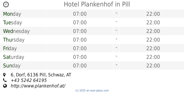
Hotel Plankenhof
Dorf 6, Pill
Lodging
read more
3.643 km
Ferienhaus Hochsonnegg, Weerberg/Tirol
Zallerstraße 105, Weerberg
Lodging
read more
3.804 km
Haus "Hüttegg"
Zallerstraße 83
Lodging
read more
4.726 km
Sonnenresidenz Friedheim
Högweg 3, Innerweerberg
Lodging
read more
5.506 km
Weierhütte
Innerbergstraße 3, Kolsassberg
Lodging
read more
📑
all categories
Accounting
Administrative area level 1
Administrative area level 2
Airport
Amusement park
Aquarium
Art gallery
Atm
Bakery
Bank
Bar
Beauty salon
Bicycle store
Book store
Bowling alley
Bus station
Cafe
Campground
Car dealer
Car rental
Car repair
Car wash
Casino
Cemetery
Church
City hall
Clothing store
Colloquial area
Convenience store
Country
Courthouse
Dentist
Department store
Doctor
Electrician
Electronics store
Embassy
Finance
Fire station
Florist
Food
Funeral home
Furniture store
Gas station
General contractor
Grocery or supermarket
Gym
Hair care
Hardware store
Health
Hindu Temple
Home goods store
Hospital
Insurance agency
Jewelry store
Laundry
Lawyer
Library
Light rail station
Liquor store
Local government office
Locality
Locksmith
Lodging
Meal delivery
Meal takeaway
Mosque
Movie rental
Movie theater
Moving company
Museum
Natural feature
Neighborhood
Night club
Painter
Park
Parking
Pet store
Pharmacy
Physiotherapist
Place of worship
Plumber
Point of interest
Police
Political
Post office
Premise
Real estate agency
Restaurant
Roofing contractor
Route
Rv park, camping
School
Shoe store
Shopping mall
Spa
Stadium
Storage
Store
Subpremise
Subway station
Supermarket
Synagogue
Taxi stand
Train station
Transit station
Travel agency
University
Veterinary care
Zoo
administrative area level 3
sublocality level 1
↑