Lodging nearby Sander Consulting e.U.
Austria
Lodging nearby Sander Consulting e.U.
Sander Consulting e.U.
Hofnerstraße 16, Göfis Österreich
contacts phone
:
+43
Latitude:
47.2402101
, Longitude:
9.6288962
read more
nearest Lodging
206 m
Ferienwohnung Metzler
49d Hofnerstraße, Göfis
Lodging
read more
495 m
Gerhard Lampert
Brunnenwald 9, Göfis
Lodging
read more
1.154 km
Gasthof Linde
Runggels 52, Göfis
Lodging
read more
1.632 km
Jugendherberge
Reichsstraße 111, Feldkirch
Lodging
read more
1.634 km
Hostel Feldkirch
Reichsstraße 111, Feldkirch
Lodging
read more
1.634 km
Youth Hostel Feldkirch
Reichsstraße 111, Feldkirch
Lodging
read more
1.784 km
Haus Rosegger
Roseggergasse 10 EG u OG, Feldkirch
Lodging
read more
1.787 km
Gasthaus stein
Illweg 4, Göfis
Lodging
read more
1.821 km
Tufers Home
Langacker 3, Göfis
Lodging
read more
1.842 km
Bodega-Bar
Feldkircher Straße 16, Frastanz
Lodging
read more
1.852 km
Montfort das Hotel
Galuragasse 7, Feldkirch
Lodging
read more
1.915 km
Pályaudvar Feldkirch
Bahnhofstraße 40-42, Feldkirch
Lodging
read more
1.967 km
Hotel am Bahnhof
Reichsstraße 177, Feldkirch
Lodging
read more
1.967 km
Hotel Hochhaus
Reichsstraße 177, Feldkirch
Lodging
read more
2.286 km
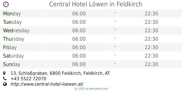
Central Hotel Löwen
Schloßgraben 13, Feldkirch
Lodging
read more
2.313 km
Hotel Post Garni KG
Schloßgraben 5, Feldkirch
Lodging
read more
2.313 km
Hotel Post
Schloßgraben 5, Feldkirch
Lodging
read more
2.321 km
Hotel Bären
Widnau 10-12, Feldkirch
Lodging
read more
2.339 km
Aksaray
Neustadt 10, Feldkirch
Lodging
read more
2.381 km
Gutwinski Hotel & Restaurant
Rosengasse 4-6, Feldkirch
Lodging
read more
2.441 km
Gasthaus Freihof
Rungeldonweg 14, Frastanz
Lodging
read more
2.558 km
Gasthof Kreuz
Sägenplatz 7, Frastanz
Lodging
read more
2.605 km
Haus Sonnenheim
Sonnenheim 35, Frastanz
Lodging
read more
2.773 km
Gasthaus Maria Grün
Mariagrüner Straße 30, Frastanz
Lodging
read more
3.373 km
Ferienhaus Bifang
Bifangstraße 21d, Feldkirch
Lodging
read more
📑
all categories
Accounting
Administrative area level 1
Administrative area level 2
Airport
Amusement park
Aquarium
Art gallery
Atm
Bakery
Bank
Bar
Beauty salon
Bicycle store
Book store
Bowling alley
Bus station
Cafe
Campground
Car dealer
Car rental
Car repair
Car wash
Casino
Cemetery
Church
City hall
Clothing store
Colloquial area
Convenience store
Country
Courthouse
Dentist
Department store
Doctor
Electrician
Electronics store
Embassy
Finance
Fire station
Florist
Food
Funeral home
Furniture store
Gas station
General contractor
Grocery or supermarket
Gym
Hair care
Hardware store
Health
Hindu Temple
Home goods store
Hospital
Insurance agency
Jewelry store
Laundry
Lawyer
Library
Light rail station
Liquor store
Local government office
Locality
Locksmith
Lodging
Meal delivery
Meal takeaway
Mosque
Movie rental
Movie theater
Moving company
Museum
Natural feature
Neighborhood
Night club
Painter
Park
Parking
Pet store
Pharmacy
Physiotherapist
Place of worship
Plumber
Point of interest
Police
Political
Post office
Premise
Real estate agency
Restaurant
Roofing contractor
Route
Rv park, camping
School
Shoe store
Shopping mall
Spa
Stadium
Storage
Store
Subpremise
Subway station
Supermarket
Synagogue
Taxi stand
Train station
Transit station
Travel agency
University
Veterinary care
Zoo
administrative area level 3
sublocality level 1
↑