Mosque nearby Бангладешки ислямски културен център във Виена
Austria
Mosque nearby Бангладешки ислямски културен център във Виена
Бангладешки ислямски културен център във Виена
85, Schönbrunner Straße, 1050, Wien, AT Austria
contacts phone
:
+43
Latitude:
48.1899078
, Longitude:
16.3531999
larger map & directions
read more
nearest Mosque
529 m
Imam Ali Islamic Centre Vienna
Mollardgasse 50, Wien
Mosque
read more
580 m
Muradiya
Embelgasse 44, Wien-Margareten
Mosque
read more
750 m
Nizami Alem Ocagi
Arbeitergasse 48, Wien
Mosque
read more
1.087 km
Qendra Kulturore Shqiptare
Schönbrunner Straße 175, Wien
Mosque
read more
1.087 km
Albanisches Kulturvereinszentrum
Schönbrunner Straße 175, Wien
Mosque
read more
1.446 km
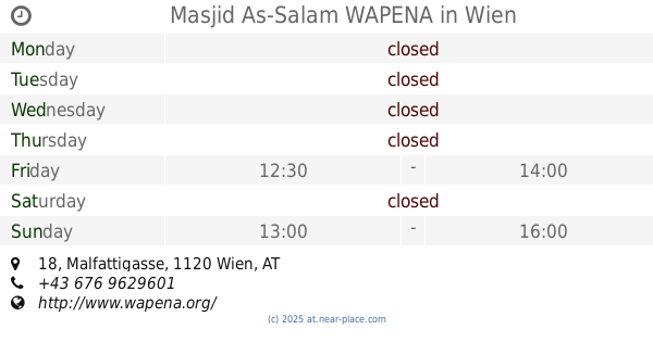
Masjid As-Salam WAPENA
Malfattigasse 18, Wien
Mosque
read more
1.526 km
Bilal Mosque Pakistani
Kauerhof 12, Wien
Mosque
read more
1.539 km
ibrahimi masjid tableighi markaz vienna
Löhrgasse 3, Wien
Mosque
read more
1.539 km
ibrahimi masjid tableighi markaz vienna مسجد
Löhrgasse 3, Wien
Mosque
read more
1.552 km
Imam El-Buhari مسجد
Eichenstraße 2C, Wien
Mosque
read more
1.552 km
El-Buhari
Eichenstraße 2C, Wien
Mosque
read more
1.552 km
Imam El-Buhari
Eichenstraße 2C, Wien
Mosque
read more
1.552 km
Albanischer Hilfs- und Kulturverein in Wien
Eichenstraße 2C, Wien
Mosque
read more
1.624 km
Islamischer Gebetsraum und Union Islamischer Kulturzentren
Pelzgasse 9, Wien-Rudolfsheim-Fünfhaus
Mosque
read more
1.647 km
Bilal-i Habeş Moschee
Niederhofstraße 9, Wien
Mosque
read more
1.647 km
Bilal-i Habeş Moschee مسجد
Niederhofstraße 9, Wien
Mosque
read more
1.652 km
Bilal Habaşi Mosque مسجد
Niederhofstraße 9, Wien-Meidling
Mosque
read more
1.652 km
Bilal Habaşi Mosque
Niederhofstraße 9, Wien-Meidling
Mosque
read more
1.875 km
Mezedonische Islamischer Kultur- und Sozialverein
Goldschlagstraße 36, Wien
Mosque
read more
2.025 km
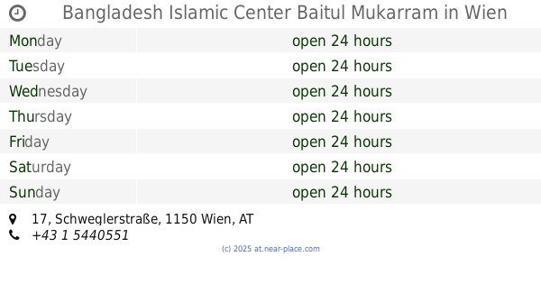
Bangladesh Islamic Center Baitul Mukarram
Schweglerstraße 17, Wien
Mosque
read more
2.162 km
Baitul Mamur Masjid (Islamic)
Scheugasse 9, Wien
Mosque
read more
2.393 km
Attaysir Mosque
Pernerstorfergasse 24, Wien
Mosque
read more
2.521 km
مسجد السلام
Leibnizgasse 38, Wien
Mosque
read more
2.619 km
Ebu Baker Moschee
Haberlgasse 21, Wien
Mosque
read more
2.623 km
Moschee
Koppstraße 1160, Wien
Mosque
read more
📑
all categories
Accounting
Administrative area level 1
Administrative area level 2
Airport
Amusement park
Aquarium
Art gallery
Atm
Bakery
Bank
Bar
Beauty salon
Bicycle store
Book store
Bowling alley
Bus station
Cafe
Campground
Car dealer
Car rental
Car repair
Car wash
Casino
Cemetery
Church
City hall
Clothing store
Colloquial area
Convenience store
Country
Courthouse
Dentist
Department store
Doctor
Electrician
Electronics store
Embassy
Finance
Fire station
Florist
Food
Funeral home
Furniture store
Gas station
General contractor
Grocery or supermarket
Gym
Hair care
Hardware store
Health
Hindu Temple
Home goods store
Hospital
Insurance agency
Jewelry store
Laundry
Lawyer
Library
Light rail station
Liquor store
Local government office
Locality
Locksmith
Lodging
Meal delivery
Meal takeaway
Mosque
Movie rental
Movie theater
Moving company
Museum
Natural feature
Neighborhood
Night club
Painter
Park
Parking
Pet store
Pharmacy
Physiotherapist
Place of worship
Plumber
Point of interest
Police
Political
Post office
Premise
Real estate agency
Restaurant
Roofing contractor
Route
Rv park, camping
School
Shoe store
Shopping mall
Spa
Stadium
Storage
Store
Subpremise
Subway station
Supermarket
Synagogue
Taxi stand
Train station
Transit station
Travel agency
University
Veterinary care
Zoo
administrative area level 3
sublocality level 1
↑