Neighborhood nearby Bahnhof-Siedlung
Austria
Neighborhood nearby Bahnhof-Siedlung
Bahnhof-Siedlung
Sankt Pölten Österreich
contacts phone
:
+43
Latitude:
48.224871
, Longitude:
15.700708
read more
nearest Neighborhood
8.857 km
Waldsiedlung
Sankt Pölten
Neighborhood
read more
21.124 km
Mitterau
Krems an der Donau
Neighborhood
read more
21.453 km
Lerchenfeldsiedlung
Krems an der Donau
Neighborhood
read more
42.974 km
Kalksburg
Wien
Neighborhood
read more
42.986 km
Waldandacht
Hernals
Neighborhood
read more
43.976 km
Rodaun
Wien
Neighborhood
read more
45.383 km
Brunn
Liesing
Neighborhood
read more
45.945 km
Schmelz
Rudolfsheim-Fünfhaus
Neighborhood
read more
46.043 km
Krohne Gesellschaft M.b.h.
Krohne Gesellschaft M.b.h., Altmannsdorfer Straße 76, Wien
Neighborhood
read more
46.476 km
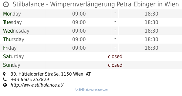
Stilbalance - Wimpernverlängerung Petra Ebinger
Stilbalance - Wimpernverlängerung Petra Ebinger, Hütteldorfer Straße 30, Wien
Neighborhood
read more
47.616 km
Wildfee's Norwegische Waldkatzen
Wildfee's Norwegische Waldkatzen, Lerchenfelder Straße 120, Wien
Neighborhood
read more
47.663 km
Altlerchenfeld
Josefstadt
Neighborhood
read more
48.326 km
Alservorstadt
Alsergrund
Neighborhood
read more
48.381 km
Sankt Ulrich
Neubau
Neighborhood
read more
48.472 km
Josefsthal
Traiskirchen
Neighborhood
read more
48.545 km
Kahlenbergerdorf
Döbling
Neighborhood
read more
48.626 km
LGS Personal Management- & Personalberatung
LGS Personal Management- & Personalberatung, Lichtenfelsgasse 5, Wien
Neighborhood
read more
48.684 km
Pavorex GmbH
Pavorex GmbH, Stadiongasse 2, Wien
Neighborhood
read more
48.688 km
Spittelberg
Neubau
Neighborhood
read more
49.262 km
Roßau
Alsergrund
Neighborhood
read more
49.398 km
Eigenheimsiedlung
Möllersdorf
Neighborhood
read more
49.657 km
Hungelbrunn
Wieden
Neighborhood
read more
49.961 km
B3 hospitality service GmbH
B3 hospitality service GmbH, Weihburggasse 18-20, Wien
Neighborhood
read more
50.141 km
Favoriten
Favoriten
Neighborhood
read more
50.709 km
Au-Siedlung
Kottingbrunn
Neighborhood
read more
📑
all categories
Accounting
Administrative area level 1
Administrative area level 2
Airport
Amusement park
Aquarium
Art gallery
Atm
Bakery
Bank
Bar
Beauty salon
Bicycle store
Book store
Bowling alley
Bus station
Cafe
Campground
Car dealer
Car rental
Car repair
Car wash
Casino
Cemetery
Church
City hall
Clothing store
Colloquial area
Convenience store
Country
Courthouse
Dentist
Department store
Doctor
Electrician
Electronics store
Embassy
Finance
Fire station
Florist
Food
Funeral home
Furniture store
Gas station
General contractor
Grocery or supermarket
Gym
Hair care
Hardware store
Health
Hindu Temple
Home goods store
Hospital
Insurance agency
Jewelry store
Laundry
Lawyer
Library
Light rail station
Liquor store
Local government office
Locality
Locksmith
Lodging
Meal delivery
Meal takeaway
Mosque
Movie rental
Movie theater
Moving company
Museum
Natural feature
Neighborhood
Night club
Painter
Park
Parking
Pet store
Pharmacy
Physiotherapist
Place of worship
Plumber
Point of interest
Police
Political
Post office
Premise
Real estate agency
Restaurant
Roofing contractor
Route
Rv park, camping
School
Shoe store
Shopping mall
Spa
Stadium
Storage
Store
Subpremise
Subway station
Supermarket
Synagogue
Taxi stand
Train station
Transit station
Travel agency
University
Veterinary care
Zoo
administrative area level 3
sublocality level 1
↑