AustriaNeighborhood nearby Erdberg
nearest Neighborhood

766 m
4.007 km
B3 hospitality service GmbH
B3 hospitality service GmbH, Weihburggasse 18-20, Wien
4.426 km
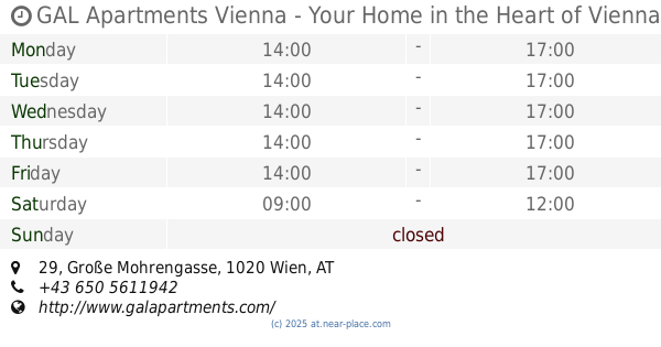
GAL Apartments Vienna - Your Home in the Heart of Vienna
GAL Apartments Vienna - Your Home in the Heart of Vienna, Große Mohrengasse 29, Wien
4.44 km
Österreichisch-Amerikanische Gesellschaft
Österreichisch-Amerikanische Gesellschaft, Stallburggasse 2, Wien
5.364 km
LGS Personal Management- & Personalberatung
LGS Personal Management- & Personalberatung, Lichtenfelsgasse 5, Wien
6.162 km
Wildfee's Norwegische Waldkatzen
Wildfee's Norwegische Waldkatzen, Lerchenfelder Straße 120, Wien
7.006 km
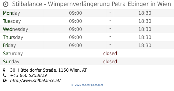
Stilbalance - Wimpernverlängerung Petra Ebinger
Stilbalance - Wimpernverlängerung Petra Ebinger, Hütteldorfer Straße 30, Wien
📑 all categories
AccountingAdministrative area level 1Administrative area level 2AirportAmusement parkAquariumArt galleryAtmBakeryBankBarBeauty salonBicycle storeBook storeBowling alleyBus stationCafeCampgroundCar dealerCar rentalCar repairCar washCasinoCemeteryChurchCity hallClothing storeColloquial areaConvenience storeCountryCourthouseDentistDepartment storeDoctorElectricianElectronics storeEmbassyFinanceFire stationFloristFoodFuneral homeFurniture storeGas stationGeneral contractorGrocery or supermarketGymHair careHardware storeHealthHindu TempleHome goods storeHospitalInsurance agencyJewelry storeLaundryLawyerLibraryLight rail stationLiquor storeLocal government officeLocalityLocksmithLodgingMeal deliveryMeal takeawayMosqueMovie rentalMovie theaterMoving companyMuseumNatural featureNeighborhoodNight clubPainterParkParkingPet storePharmacyPhysiotherapistPlace of worshipPlumberPoint of interestPolicePoliticalPost officePremiseReal estate agencyRestaurantRoofing contractorRouteRv park, campingSchoolShoe storeShopping mallSpaStadiumStorageStoreSubpremiseSubway stationSupermarketSynagogueTaxi standTrain stationTransit stationTravel agencyUniversityVeterinary careZooadministrative area level 3sublocality level 1