Night club nearby Cabaret Fledermaus
Austria
Night club nearby Cabaret Fledermaus
Cabaret Fledermaus
2, Spiegelgasse, 1010, Wien, AT Ausztria
contacts phone
:
+43 1 5870196
website:
www.fledermaus.at
Latitude:
48.2078796
, Longitude:
16.3703221
larger map & directions
read more
nearest Night club
243 m
Hellseherin Ezra
Rauhensteingasse 10, Wien
Night club
read more
260 m
Club Alice
Josefsplatz 6, Wien
Night club
read more
317 m
VIENNA Technology, Transfer Corporation GmbH
Kramergasse 9, Wien
Night club
read more
453 m
Hudson Diskotheken Betriebsgesellschaft m.b.H.
Hanuschgasse 3, Wien
Night club
read more
455 m
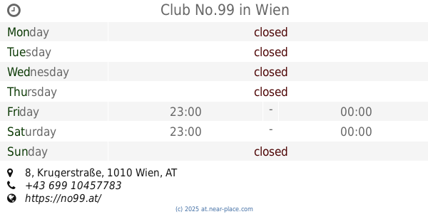
Club No.99
Krugerstraße 8, Wien
Night club
read more
480 m
Beverly Hills Club Vienna
Seilerstätte 5, Wien
Night club
read more
482 m
Porgy & Bess
Riemergasse 11, Wien
Night club
read more
512 m
BALALAIKA
Fischerstiege 1-7, Wien
Night club
read more
524 m
Bettel-Alm - Das Original
Johannesgasse 12, Wien
Night club
read more
533 m
Babuder's - Karaoke
Tiefer Graben 22, Wien
Night club
read more
537 m
Tina's Eve
Schellinggasse 1, Wien
Night club
read more
545 m
Babylon Wien
1, Seilerstätte, Wien
Night club
read more
552 m
Vienna Gnadenlos- der Club im Bermudadreieck
Seitenstettengasse 5, Wien
Night club
read more
554 m
Actress Lounge
Liebenberggasse 1, Wien
Night club
read more
583 m
Jazzland
Franz-Josefs-Kai 29, Wien
Night club
read more
602 m
Prime
Salzgries 4, Wien
Night club
read more
633 m
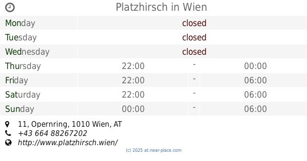
Platzhirsch
Opernring 11, Wien
Night club
read more
638 m
Russian Begleitargentur GmbH Vienna
1010, Opernring 13, Wien
Night club
read more
674 m
Säulenhalle
Burgring, Wien
Night club
read more
793 m
Art Dinner Club
Falkestraße 5, Wien
Night club
read more
818 m
Mercado-Nikkei
Stubenring 18, Wien
Night club
read more
855 m
Yamm!
Universitätsring 10, Wien
Night club
read more
1.085 km
ZERO INCH Digitale Medien GmbH
Kolingasse 9, Wien
Night club
read more
1.114 km
Club Alpha
Untere Donaustraße 21, Wien
Night club
read more
1.28 km
First Club
Fillgradergasse 16, Wien
Night club
read more
📑
all categories
Accounting
Administrative area level 1
Administrative area level 2
Airport
Amusement park
Aquarium
Art gallery
Atm
Bakery
Bank
Bar
Beauty salon
Bicycle store
Book store
Bowling alley
Bus station
Cafe
Campground
Car dealer
Car rental
Car repair
Car wash
Casino
Cemetery
Church
City hall
Clothing store
Colloquial area
Convenience store
Country
Courthouse
Dentist
Department store
Doctor
Electrician
Electronics store
Embassy
Finance
Fire station
Florist
Food
Funeral home
Furniture store
Gas station
General contractor
Grocery or supermarket
Gym
Hair care
Hardware store
Health
Hindu Temple
Home goods store
Hospital
Insurance agency
Jewelry store
Laundry
Lawyer
Library
Light rail station
Liquor store
Local government office
Locality
Locksmith
Lodging
Meal delivery
Meal takeaway
Mosque
Movie rental
Movie theater
Moving company
Museum
Natural feature
Neighborhood
Night club
Painter
Park
Parking
Pet store
Pharmacy
Physiotherapist
Place of worship
Plumber
Point of interest
Police
Political
Post office
Premise
Real estate agency
Restaurant
Roofing contractor
Route
Rv park, camping
School
Shoe store
Shopping mall
Spa
Stadium
Storage
Store
Subpremise
Subway station
Supermarket
Synagogue
Taxi stand
Train station
Transit station
Travel agency
University
Veterinary care
Zoo
administrative area level 3
sublocality level 1
↑