Night club nearby La Casa De Boi
Coronavirus disease (COVID-19) Situation
confirmed cases
6081287
deaths
22542
Austria
Night club nearby La Casa De Boi
La Casa De Boi
Graf-Starhemberg-Gasse, Wien Österreich
contacts phone
:
+43
Latitude:
48.1898765
, Longitude:
16.3702161
read more
nearest Night club
371 m
Chamäleon Club
Favoritenstraße 26 Eingang, Mayerhofgasse, Wien
Night club
read more
371 m
Moonbite Club
Favoritenstraße 26 Eingang, Mayerhofgasse, Wien
Night club
read more
523 m
K.Ö.St.V. Herulia Wien
Phorusgasse 14, Wien
Night club
read more
539 m
Asia Studio Lov5
Mittersteig 8, Wien
Night club
read more
672 m
ÖBB Lounge
Am Hauptbahnhof 1, Wien
Night club
read more
921 m
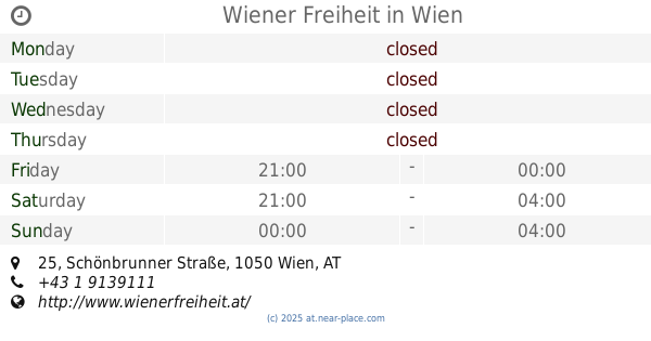
Wiener Freiheit
Schönbrunner Straße 25, Wien
Night club
read more
938 m
ost klub
Schwarzenbergplatz 10, Wien
Night club
read more
938 m
Schwarzberg
Schwarzenbergplatz 10, Wien
Night club
read more
1.032 km
goodmann
Rechte Wienzeile 23, Wien
Night club
read more
1.053 km
Burschenschaft WESTFALIA
Rechte Wienzeile 19, Wien
Night club
read more
1.053 km
Burschenschaft WESTFALIA
Rechte Wienzeile 17, Wien
Night club
read more
1.104 km
Club Schwarzenberg
Schwarzenbergplatz 7, Wien
Night club
read more
1.203 km
HARD ON
Hamburgerstraße 4, Wien
Night club
read more
1.203 km
LMC Vienna
Hamburgerstraße 4, Wien
Night club
read more
1.255 km
Kulturforum DanAustria
Keilgasse 12, Wien
Night club
read more
1.411 km
Luftbad
Luftbadgasse 17, Wien
Night club
read more
1.554 km
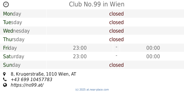
Club No.99
Krugerstraße 8, Wien
Night club
read more
1.821 km
STYLEZ
Neubaugasse 10, Wien
Night club
read more
1.875 km
Tresor Club
Arthaberplatz 2, Wien
Night club
read more
1.881 km
Babylon Wien
1, Seilerstätte, Wien
Night club
read more
1.92 km
6LOUNGE Nightclub
Senefeldergasse 44, Wien
Night club
read more
1.944 km
Porgy & Bess
Riemergasse 11, Wien
Night club
read more
2.006 km
Säulenhalle
Burgring, Wien
Night club
read more
2.045 km
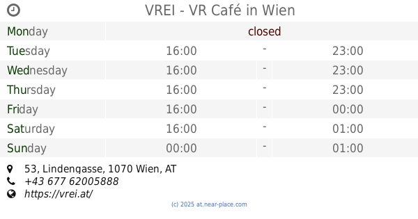
VREI - VR Café
Lindengasse 53, Wien
Night club
read more
2.343 km
Dual
Burggasse 70, Wien
Night club
read more
📑
all categories
Accounting
Administrative area level 1
Administrative area level 2
Airport
Amusement park
Aquarium
Art gallery
Atm
Bakery
Bank
Bar
Beauty salon
Bicycle store
Book store
Bowling alley
Bus station
Cafe
Campground
Car dealer
Car rental
Car repair
Car wash
Casino
Cemetery
Church
City hall
Clothing store
Colloquial area
Convenience store
Country
Courthouse
Dentist
Department store
Doctor
Electrician
Electronics store
Embassy
Finance
Fire station
Florist
Food
Funeral home
Furniture store
Gas station
General contractor
Grocery or supermarket
Gym
Hair care
Hardware store
Health
Hindu Temple
Home goods store
Hospital
Insurance agency
Jewelry store
Laundry
Lawyer
Library
Light rail station
Liquor store
Local government office
Locality
Locksmith
Lodging
Meal delivery
Meal takeaway
Mosque
Movie rental
Movie theater
Moving company
Museum
Natural feature
Neighborhood
Night club
Painter
Park
Parking
Pet store
Pharmacy
Physiotherapist
Place of worship
Plumber
Point of interest
Police
Political
Post office
Premise
Real estate agency
Restaurant
Roofing contractor
Route
Rv park, camping
School
Shoe store
Shopping mall
Spa
Stadium
Storage
Store
Subpremise
Subway station
Supermarket
Synagogue
Taxi stand
Train station
Transit station
Travel agency
University
Veterinary care
Zoo
administrative area level 3
sublocality level 1
↑