Night club nearby PMK
Austria
Night club nearby PMK
PMK
18-20, Ingenieur-Etzel-Straße, 6020, Innsbruck, Innsbruck, AT Austria
contacts phone
:
+43 512 908049
website:
www.pmk.or.at
Latitude:
47.2675938
, Longitude:
11.402065
larger map & directions
read more
nearest Night club
196 m
Felix Innsbruck
Innsbruck
Night club
read more
250 m
Party Club Flash
Ingenieur-Etzel-Straße 25, Innsbruck
Night club
read more
271 m
Bad Girls Tabledance
Ingenieur-Etzel-Straße 41, Innsbruck
Night club
read more
336 m
Queens Club
Amraser Straße 6, Innsbruck
Night club
read more
373 m
Grand Hotel Europa
Südtiroler Platz 2, Innsbruck
Night club
read more
390 m
mfg - Bar
Universitätsstraße 5, Innsbruck
Night club
read more
500 m
Espressione Oldy Bar
Adamgasse 5, Innsbruck
Night club
read more
538 m
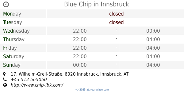
Blue Chip
Wilhelm-Greil-Straße 17, Innsbruck
Night club
read more
646 m
Segabar
Maria-Theresien-Straße 8, Innsbruck
Night club
read more
696 m
Bacchus Discothek
Salurner Straße 18, Innsbruck
Night club
read more
735 m
Dachsbau
Herzog-Otto-Straße 8, Innsbruck
Night club
read more
756 m
Tabledance Tirol
Salurner Straße 15, Innsbruck
Night club
read more
873 m
Maxim Night Club
Karmelitergasse 5/7, Innsbruck
Night club
read more
873 m
Maxim Nachtclub
Karmelitergasse 5/7, Innsbruck
Night club
read more
880 m
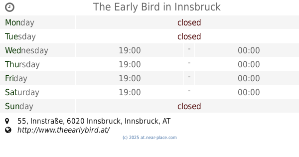
The Early Bird
Innstraße 55, Innsbruck
Night club
read more
906 m
Night Club Kurbnhaus KNEZ MISEL
Innstraße 5, Innsbruck
Night club
read more
923 m
Laufhsus Nightclub Knez
Innstraße, Innsbruck
Night club
read more
944 m
Lounge 69
Höttinger Gasse 7, Innsbruck
Night club
read more
1.089 km
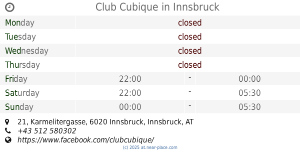
Club Cubique
Karmelitergasse 21, Innsbruck
Night club
read more
1.57 km
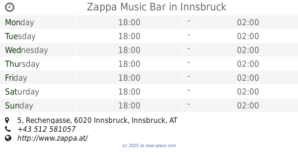
Zappa Music Bar
Rechengasse 5, Innsbruck
Night club
read more
2.359 km
VAZ HAFEN
Innrain 149, Innsbruck
Night club
read more
3.9 km
Roner Lencsi Club Moonlight
Technikerstraße 5, Innsbruck
Night club
read more
4.58 km
ARBÖ Ortsklub Rum
Korngasse 12, Rum
Night club
read more
5.969 km
Club Escalera
Loretto-Umgebung 1, Thaur
Night club
read more
12.097 km
Löwebgrube
Kirchstraße 2, Zirl
Night club
read more
📑
all categories
Accounting
Administrative area level 1
Administrative area level 2
Airport
Amusement park
Aquarium
Art gallery
Atm
Bakery
Bank
Bar
Beauty salon
Bicycle store
Book store
Bowling alley
Bus station
Cafe
Campground
Car dealer
Car rental
Car repair
Car wash
Casino
Cemetery
Church
City hall
Clothing store
Colloquial area
Convenience store
Country
Courthouse
Dentist
Department store
Doctor
Electrician
Electronics store
Embassy
Finance
Fire station
Florist
Food
Funeral home
Furniture store
Gas station
General contractor
Grocery or supermarket
Gym
Hair care
Hardware store
Health
Hindu Temple
Home goods store
Hospital
Insurance agency
Jewelry store
Laundry
Lawyer
Library
Light rail station
Liquor store
Local government office
Locality
Locksmith
Lodging
Meal delivery
Meal takeaway
Mosque
Movie rental
Movie theater
Moving company
Museum
Natural feature
Neighborhood
Night club
Painter
Park
Parking
Pet store
Pharmacy
Physiotherapist
Place of worship
Plumber
Point of interest
Police
Political
Post office
Premise
Real estate agency
Restaurant
Roofing contractor
Route
Rv park, camping
School
Shoe store
Shopping mall
Spa
Stadium
Storage
Store
Subpremise
Subway station
Supermarket
Synagogue
Taxi stand
Train station
Transit station
Travel agency
University
Veterinary care
Zoo
administrative area level 3
sublocality level 1
↑