Night club nearby Töbelehalle Götzis
Austria
Night club nearby Töbelehalle Götzis
Töbelehalle Götzis
Töbeleweg 8, Götzis Austria
contacts phone
:
+43
Latitude:
47.3318574
, Longitude:
9.6460938
read more
nearest Night club
1.607 km
Tabledance Club-Europa gogo-Bar
Herrschaftswiesen 13, Koblach
Night club
read more
1.607 km
Night Club M1
Herrschaftswissen 13, Koblach
Night club
read more
1.863 km
N-Joy
Sennemahd 9, Altach
Night club
read more
2.82 km
Feldaker Aseck
Broma 5, Koblach
Night club
read more
2.9 km
Ottengravur
Kaiser-Franz-Josef-Straße 130, Hohenems
Night club
read more
3.704 km
K-Shake
Industriezone 8, Röthis
Night club
read more
4.422 km
Tabledance Hot-Gogo-Club
Angelika-Kauffmann-Straße 1, Hohenems
Night club
read more
6.366 km
schöpfle rankweil
Grundweg 4, Rankweil
Night club
read more
6.845 km
El Capitán
Langgasse 116, Rankweil
Night club
read more
6.989 km
Orchidee Tabledance
Furchgasse 2, Hohenems
Night club
read more
8.07 km
Level 12
Stöckenstraße 12, Dornbirn
Night club
read more
8.572 km
Freizeit Verein Slotrunners
J. Schmidheinystrasse 240, Balgach
Night club
read more
8.73 km
Taksim Lounge Bar
23, Wallenmahd, Dornbirn
Night club
read more
8.976 km
Kanalbar SRB
Kanalstrasse, Rüthi
Night club
read more
9.797 km
Bácshrums
Agasella 12, Göfis
Night club
read more
10.26 km
Moonlight Tabledance
Lustenauer Straße 83, Dornbirn
Night club
read more
11.207 km
rauch club
Marktplatz 9, Feldkirch
Night club
read more
11.444 km
Kabinett Club
Bildgasse 1, Dornbirn
Night club
read more
11.661 km
Offene Jugendarbeit Dornbirn
Schlachthausstraße 11, Dornbirn
Night club
read more
12.926 km
Tabledance VIP
Liechtensteiner Straße 106, Feldkirch
Night club
read more
14.907 km
Red Sun Fußach
Ziegeleistraße 5, Fußach
Night club
read more
15.775 km
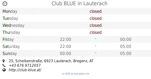
Club BLUE
Scheibenstraße 25, Lauterach
Night club
read more
15.793 km
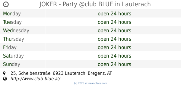
JOKER - Party @club BLUE
Scheibenstraße 25, Lauterach
Night club
read more
15.879 km
Club Montana
Kreuzen 4, Dornbirn
Night club
read more
15.879 km
Nightstar Club
Kreuzen 4, Dornbirn
Night club
read more
📑
all categories
Accounting
Administrative area level 1
Administrative area level 2
Airport
Amusement park
Aquarium
Art gallery
Atm
Bakery
Bank
Bar
Beauty salon
Bicycle store
Book store
Bowling alley
Bus station
Cafe
Campground
Car dealer
Car rental
Car repair
Car wash
Casino
Cemetery
Church
City hall
Clothing store
Colloquial area
Convenience store
Country
Courthouse
Dentist
Department store
Doctor
Electrician
Electronics store
Embassy
Finance
Fire station
Florist
Food
Funeral home
Furniture store
Gas station
General contractor
Grocery or supermarket
Gym
Hair care
Hardware store
Health
Hindu Temple
Home goods store
Hospital
Insurance agency
Jewelry store
Laundry
Lawyer
Library
Light rail station
Liquor store
Local government office
Locality
Locksmith
Lodging
Meal delivery
Meal takeaway
Mosque
Movie rental
Movie theater
Moving company
Museum
Natural feature
Neighborhood
Night club
Painter
Park
Parking
Pet store
Pharmacy
Physiotherapist
Place of worship
Plumber
Point of interest
Police
Political
Post office
Premise
Real estate agency
Restaurant
Roofing contractor
Route
Rv park, camping
School
Shoe store
Shopping mall
Spa
Stadium
Storage
Store
Subpremise
Subway station
Supermarket
Synagogue
Taxi stand
Train station
Transit station
Travel agency
University
Veterinary care
Zoo
administrative area level 3
sublocality level 1
↑