Park nearby Brunnen Am Pöstlingberg
Coronavirus disease (COVID-19) Situation
confirmed cases
6081287
deaths
22542
Austria
Park nearby Brunnen Am Pöstlingberg
Brunnen Am Pöstlingberg
14, Linz Austria
contacts phone
:
+43
Latitude:
48.323228
, Longitude:
14.2582569
read more
nearest Park
1.492 km
Pinguine Hölderlinstraße (1961) KünstlerIn: Friederike Stolz
Hölderlinstraße 23, Linz
Park
read more
1.849 km
Jubiläumsbrunnen Urfahr Freistädter Straße
Freistädter Straße, Linz
Park
read more
1.924 km
Urfahrwänd, Linz
Linz
Park
read more
1.946 km
Grünzeit Konrad & Matula OG
Leonfeldner Straße 10, Linz
Park
read more
2.016 km
Öffentlicher Park
Alt, Linz
Park
read more
2.189 km
Harbachpark
Leonfeldner Straße 99-101, Linz
Park
read more
2.228 km
Bernaschekpark
Urfahr
Park
read more
2.274 km
Donaustrand Urfahr
Urfahr
Park
read more
2.363 km
Donaugarten
Obere Donaustraße, Linz
Park
read more
2.596 km
Schloss Park
Schlossberg 1, Linz
Park
read more
2.596 km
Schlosspark
Schlossberg 1, Linz
Park
read more
2.695 km
Kleingartenverein Erdsegen
Uppsalaweg 17, Linz
Park
read more
2.743 km
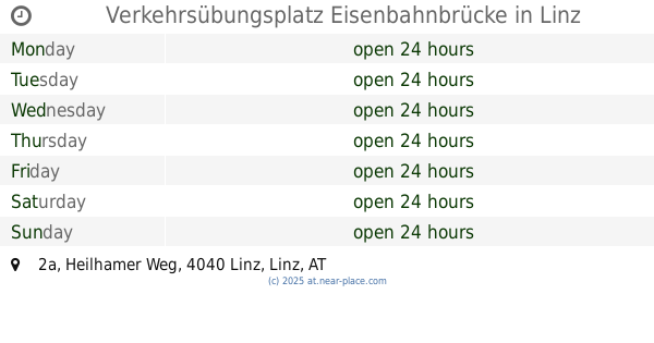
Verkehrsübungsplatz Eisenbahnbrücke
Heilhamer Weg 2a, Linz
Park
read more
2.816 km
Morgentaugarten Freinberg
Fritz-Lach-Weg, Linz
Park
read more
2.829 km
Öffentliche Hundefreilauffläche
Leonding
Park
read more
2.88 km
Obstbaumgarten Kampmüllerweg
Kampmüllerweg 47, Linz
Park
read more
2.952 km
Bayer-Brunnen
Ernst-Koref-Promenade, Linz
Park
read more
2.958 km
Donaupark
Untere Donaulände 9, Linz
Park
read more
3.174 km
Brunnen "Hand" "Hundertwasserbrunnen"
Spittelwiese, Linz
Park
read more
3.311 km
Brunnen Ursulinenhof
Landstraße, Linz
Park
read more
3.495 km
Stadtpark
Huemerstraße 3, Linz
Park
read more
3.608 km
City-Park
Linz
Park
read more
3.735 km
Schillerpark
Landstraße 89, Linz
Park
read more
3.945 km
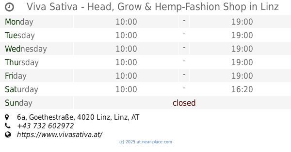
Viva Sativa - Head, Grow & Hemp-Fashion Shop
Goethestraße 6a, Linz
Park
read more
3.945 km
Viva Sativa - Head & Hemp-Fashion Shop
Goethestraße 6a, Linz
Park
read more
📑
all categories
Accounting
Administrative area level 1
Administrative area level 2
Airport
Amusement park
Aquarium
Art gallery
Atm
Bakery
Bank
Bar
Beauty salon
Bicycle store
Book store
Bowling alley
Bus station
Cafe
Campground
Car dealer
Car rental
Car repair
Car wash
Casino
Cemetery
Church
City hall
Clothing store
Colloquial area
Convenience store
Country
Courthouse
Dentist
Department store
Doctor
Electrician
Electronics store
Embassy
Finance
Fire station
Florist
Food
Funeral home
Furniture store
Gas station
General contractor
Grocery or supermarket
Gym
Hair care
Hardware store
Health
Hindu Temple
Home goods store
Hospital
Insurance agency
Jewelry store
Laundry
Lawyer
Library
Light rail station
Liquor store
Local government office
Locality
Locksmith
Lodging
Meal delivery
Meal takeaway
Mosque
Movie rental
Movie theater
Moving company
Museum
Natural feature
Neighborhood
Night club
Painter
Park
Parking
Pet store
Pharmacy
Physiotherapist
Place of worship
Plumber
Point of interest
Police
Political
Post office
Premise
Real estate agency
Restaurant
Roofing contractor
Route
Rv park, camping
School
Shoe store
Shopping mall
Spa
Stadium
Storage
Store
Subpremise
Subway station
Supermarket
Synagogue
Taxi stand
Train station
Transit station
Travel agency
University
Veterinary care
Zoo
administrative area level 3
sublocality level 1
↑