Park nearby Donau Park
Austria
Park nearby Donau Park
Donau Park
Untere Donaulände 9, Linz Ausztria
contacts phone
:
+43
Latitude:
48.3128317
, Longitude:
14.2950772
read more
nearest Park
Donaupark
Untere Donaulände 9, Linz
Park
read more
332 m
Bayer-Brunnen
Ernst-Koref-Promenade, Linz
Park
read more
445 m
Hochstrahlbrunnen
Untere Donaulände, Linz
Park
read more
719 m
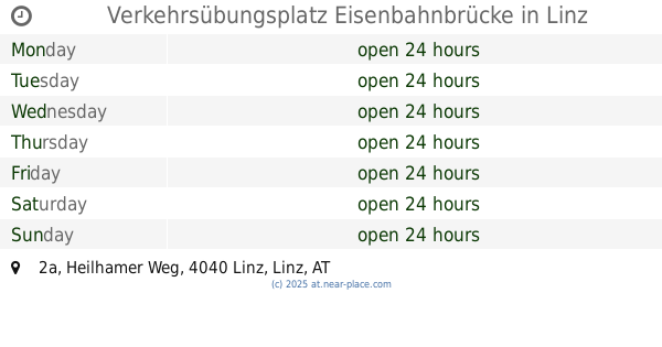
Verkehrsübungsplatz Eisenbahnbrücke
Heilhamer Weg 2a, Linz
Park
read more
801 m
Stadtpark
Huemerstraße 3, Linz
Park
read more
801 m
Stadt Park
Huemerstraße 3, Linz
Park
read more
852 m
Jubiläumsbrunnen Adalbert-Stifter-Platz
Adalbert-Stifter-Platz, Linz
Park
read more
945 m
Öffentlicher Park
Alt, Linz
Park
read more
1.011 km
Sirenenbrunnen - Brückenkopfgebäude West
Im Hof des Brückenkopfgebäudes West, Hauptplatz 8, Linz
Park
read more
1.054 km
Neptunbrunnen
Hauptplatz, Linz
Park
read more
1.054 km
Fuente de Neptuno
Hauptplatz, Linz
Park
read more
1.054 km
Neptune Fountain
Hauptplatz, Linz
Park
read more
1.059 km
Grünzeit Konrad & Matula OG
Leonfeldner Straße 10, Linz
Park
read more
1.096 km
Sparkassenbrunnen
Landstraße, Linz
Park
read more
1.123 km
Wasserspeiender Gnom
Promenade 16, Linz
Park
read more
1.17 km
AKH Park
Linz
Park
read more
1.176 km
Brunnen vor dem Landhaus
Klosterstraße, Linz
Park
read more
1.18 km
Promenadenpark
Promenade 22-24, Linz
Park
read more
1.244 km
Georgsbrunnen am Tummelplatz
Tummelplatz, Linz
Park
read more
1.26 km
Donaustrand Winterhafen
Linz
Park
read more
1.707 km
Schillerpark
Landstraße 89, Linz
Park
read more
1.839 km
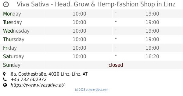
Viva Sativa - Head, Grow & Hemp-Fashion Shop
Goethestraße 6a, Linz
Park
read more
2.013 km
Harbachpark
Leonfeldner Straße 99-101, Linz
Park
read more
2.215 km
Bauernberg Park
Bernardisstraße 1, Linz
Park
read more
2.342 km
Botanischer Garten Linz
Roseggerstraße 20, Linz
Park
read more
📑
all categories
Accounting
Administrative area level 1
Administrative area level 2
Airport
Amusement park
Aquarium
Art gallery
Atm
Bakery
Bank
Bar
Beauty salon
Bicycle store
Book store
Bowling alley
Bus station
Cafe
Campground
Car dealer
Car rental
Car repair
Car wash
Casino
Cemetery
Church
City hall
Clothing store
Colloquial area
Convenience store
Country
Courthouse
Dentist
Department store
Doctor
Electrician
Electronics store
Embassy
Finance
Fire station
Florist
Food
Funeral home
Furniture store
Gas station
General contractor
Grocery or supermarket
Gym
Hair care
Hardware store
Health
Hindu Temple
Home goods store
Hospital
Insurance agency
Jewelry store
Laundry
Lawyer
Library
Light rail station
Liquor store
Local government office
Locality
Locksmith
Lodging
Meal delivery
Meal takeaway
Mosque
Movie rental
Movie theater
Moving company
Museum
Natural feature
Neighborhood
Night club
Painter
Park
Parking
Pet store
Pharmacy
Physiotherapist
Place of worship
Plumber
Point of interest
Police
Political
Post office
Premise
Real estate agency
Restaurant
Roofing contractor
Route
Rv park, camping
School
Shoe store
Shopping mall
Spa
Stadium
Storage
Store
Subpremise
Subway station
Supermarket
Synagogue
Taxi stand
Train station
Transit station
Travel agency
University
Veterinary care
Zoo
administrative area level 3
sublocality level 1
↑