Park nearby Hundezone Traiskirchen
Austria
Park nearby Hundezone Traiskirchen
Hundezone Traiskirchen
28, Badgasse, 2514, Traiskirchen, Baden, AT Österreich
contacts phone
:
+43
Latitude:
48.0168761
, Longitude:
16.3056166
larger map & directions
read more
nearest Park
670 m
Stadtpark Traiskirchen
Walther Von Der Vogelweide-Straße, Traiskirchen
Park
read more
670 m
Traiskirchen Park
Walther Von Der Vogelweide-Straße, Traiskirchen
Park
read more
1.366 km
Bilandzija GmbH
Johann-Wolfgang-Goethe-Straße 9, Traiskirchen
Park
read more
2.576 km
Schloss Park
Traiskirchen
Park
read more
2.994 km
Hundewiese
Trumau
Park
read more
3.396 km
Beserlpark
Pfaffstätten
Park
read more
3.451 km
Taubenabwehr Wilhelm Hasenöhrl
Hauptstraße 4, Guntramsdorf
Park
read more
4.039 km
Radlpark
Trumau
Park
read more
4.095 km
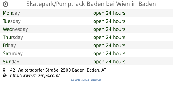
Skatepark/Pumptrack Baden bei Wien
Waltersdorfer Straße 42, Baden
Park
read more
4.331 km
Ökopark Mühlgasse
Baden
Park
read more
4.39 km
Hundeauslaufzone Baden
Trudo-Exner-Brücke, Baden
Park
read more
4.992 km
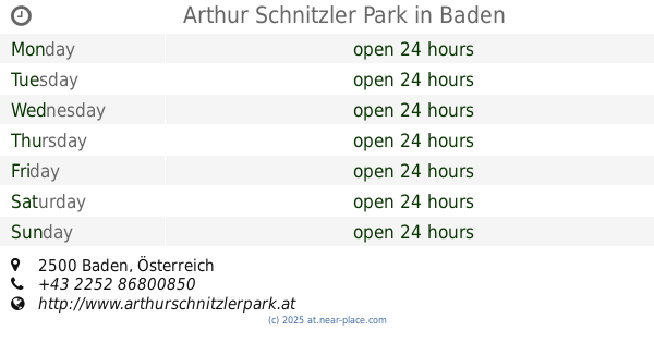
Arthur Schnitzler Park
Baden
Park
read more
4.992 km
Arthur Schnitzler Park
Baden bei Wien
Park
read more
5.2 km
EICHKOGEL
Gemeinden, Guntramsdorf
Park
read more
8.352 km
Arnold Schönberg-Park
Mödling
Park
read more
9.086 km
Kurpark Bad Vöslau
Bad Vöslau
Park
read more
10.506 km
A.F.T. Biribauer+Gstettner GmbH
Anton Bruckner-Gasse 18, Brunn am Gebirge
Park
read more
11.289 km
pumptrack | Skatepark
Franz-Piperger-Gasse, Perchtoldsdorf
Park
read more
11.71 km
Generationen Park
Trauttmansdorffstraße, Leobersdorf
Park
read more
12.867 km
Perchtoldsdorfer Heide
Schutzhausstraße, Perchtoldsdorf
Park
read more
13.349 km
Engelbert-Schliemann Park
Rodaun, Wien
Park
read more
13.527 km
ML Gartenpflege - Dipl. -Ing. Milan Lujic
Breitenfurter Straße 380/28, Wien
Park
read more
13.55 km
Herbert-Mayr-Park
Viena
Park
read more
14.388 km
Doktor Josef Schoiswohl-Park
Viena
Park
read more
14.847 km
Steine der Erinnerung - Risa und Karl Beran
Maurer Lange Gasse 85, Wien
Park
read more
📑
all categories
Accounting
Administrative area level 1
Administrative area level 2
Airport
Amusement park
Aquarium
Art gallery
Atm
Bakery
Bank
Bar
Beauty salon
Bicycle store
Book store
Bowling alley
Bus station
Cafe
Campground
Car dealer
Car rental
Car repair
Car wash
Casino
Cemetery
Church
City hall
Clothing store
Colloquial area
Convenience store
Country
Courthouse
Dentist
Department store
Doctor
Electrician
Electronics store
Embassy
Finance
Fire station
Florist
Food
Funeral home
Furniture store
Gas station
General contractor
Grocery or supermarket
Gym
Hair care
Hardware store
Health
Hindu Temple
Home goods store
Hospital
Insurance agency
Jewelry store
Laundry
Lawyer
Library
Light rail station
Liquor store
Local government office
Locality
Locksmith
Lodging
Meal delivery
Meal takeaway
Mosque
Movie rental
Movie theater
Moving company
Museum
Natural feature
Neighborhood
Night club
Painter
Park
Parking
Pet store
Pharmacy
Physiotherapist
Place of worship
Plumber
Point of interest
Police
Political
Post office
Premise
Real estate agency
Restaurant
Roofing contractor
Route
Rv park, camping
School
Shoe store
Shopping mall
Spa
Stadium
Storage
Store
Subpremise
Subway station
Supermarket
Synagogue
Taxi stand
Train station
Transit station
Travel agency
University
Veterinary care
Zoo
administrative area level 3
sublocality level 1
↑