Park nearby Leonding Park
Austria
Park nearby Leonding Park
Leonding Park
Gartenweg 26, Leonding Ausztria
contacts phone
:
+43
Latitude:
48.270982
, Longitude:
14.2585919
read more
nearest Park
356 m
Garten Labor Leonding
Parkstraße 23
Park
read more
594 m
Kleingartenverein Grundbach
Trixnerweg, Leonding
Park
read more
893 m
Isidor Park
Bruno-Gallee-Weg 26, Leonding
Park
read more
1.004 km
Michaeli Park
Michaelsbergstraße 10, Leonding
Park
read more
1.818 km
Drei-Grazien-Brunnen
Schiffmannstraße, Linz
Park
read more
1.848 km
Blick in Richtung Doblerholz
Fellinger Straße, Leonding
Park
read more
2.218 km
Green Habit
Schirmerstraße 28c, Leonding
Park
read more
2.661 km
Kürnbergerwald
Forsthausstraße 4060, Leonding
Park
read more
2.731 km
Landschaftspark Bindermichl-Spallerhof - Bellevuepark
Mühlkreisautobahn, Linz
Park
read more
2.797 km
Laskahofpark
Salzburger Straße 241, Linz
Park
read more
2.832 km
Ziegeleipark
Innenstadt
Park
read more
2.965 km
Jubiläumsbrunnen Einkaufszentrum Niedernhart
Einsteinstraße 5, Linz
Park
read more
2.972 km
Park
Kopernikusstraße, Linz
Park
read more
3.009 km
Brunnenskulptur im Haidgatternpark
Daimlerstraße, Linz
Park
read more
3.061 km
Botanischer Garten Linz
Roseggerstraße 20, Linz
Park
read more
3.102 km
Bronzebrunnen (ehemalige Hatschekvilla), 1559
Auf der Gugl, Linz
Park
read more
3.167 km
Bauernberg Park
Bernardisstraße 1, Linz
Park
read more
3.184 km
Bauernberg Park
Linz
Park
read more
3.212 km
Brunnen Bahnhofsvorplatz
Bahnhofplatz, Linz
Park
read more
3.593 km
Freude am Schönen
Linz
Park
read more
3.602 km
Lausbub, Bronzeplastik
Volksgartenstraße, Linz
Park
read more
3.644 km
Volksgarten
Linz
Park
read more
3.802 km
Viva Sativa - Head & Hemp-Fashion Shop
Goethestraße 6a, Linz
Park
read more
3.802 km
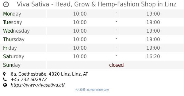
Viva Sativa - Head, Grow & Hemp-Fashion Shop
Goethestraße 6a, Linz
Park
read more
3.823 km
Schillerpark
Landstraße 89, Linz
Park
read more
📑
all categories
Accounting
Administrative area level 1
Administrative area level 2
Airport
Amusement park
Aquarium
Art gallery
Atm
Bakery
Bank
Bar
Beauty salon
Bicycle store
Book store
Bowling alley
Bus station
Cafe
Campground
Car dealer
Car rental
Car repair
Car wash
Casino
Cemetery
Church
City hall
Clothing store
Colloquial area
Convenience store
Country
Courthouse
Dentist
Department store
Doctor
Electrician
Electronics store
Embassy
Finance
Fire station
Florist
Food
Funeral home
Furniture store
Gas station
General contractor
Grocery or supermarket
Gym
Hair care
Hardware store
Health
Hindu Temple
Home goods store
Hospital
Insurance agency
Jewelry store
Laundry
Lawyer
Library
Light rail station
Liquor store
Local government office
Locality
Locksmith
Lodging
Meal delivery
Meal takeaway
Mosque
Movie rental
Movie theater
Moving company
Museum
Natural feature
Neighborhood
Night club
Painter
Park
Parking
Pet store
Pharmacy
Physiotherapist
Place of worship
Plumber
Point of interest
Police
Political
Post office
Premise
Real estate agency
Restaurant
Roofing contractor
Route
Rv park, camping
School
Shoe store
Shopping mall
Spa
Stadium
Storage
Store
Subpremise
Subway station
Supermarket
Synagogue
Taxi stand
Train station
Transit station
Travel agency
University
Veterinary care
Zoo
administrative area level 3
sublocality level 1
↑