Pharmacy nearby Apotheke Zum heiligen Florian
Austria
Pharmacy nearby Apotheke Zum heiligen Florian
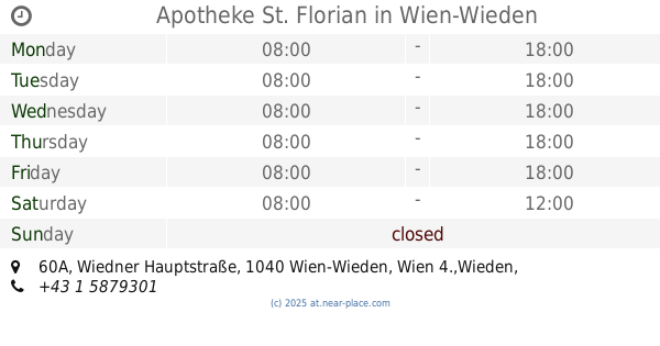
Apotheke Zum heiligen Florian
Wiedner Hauptstraße 60A, Wien-Wieden Österreich
contacts phone
:
+43
Latitude:
48.1910859
, Longitude:
16.3665326
read more
nearest Pharmacy
Apotheke St. Florian
Wiedner Hauptstraße 60A, Wien-Wieden
Pharmacy
read more
451 m
STERN-APOTHEKE
Favoritenstraße 25, Wien
Pharmacy
read more
465 m
Pharmadroga Großhandel GesmbH
Favoritenstraße 14, Wien
Pharmacy
read more
476 m
Schutzengel-Apotheke
Favoritenstraße 11, Wien
Pharmacy
read more
512 m
Johann-Strauss-Apotheke
Johann-Strauß-Gasse 32, Wien
Pharmacy
read more
512 m
Johann Strauss Pharmacy
Johann-Strauß-Gasse 32, Wien
Pharmacy
read more
523 m
Apotheke zum Einhorn
Margaretenstraße 31, Wien
Pharmacy
read more
543 m
Margareten-Apotheke
Margaretenstraße 75, Wien
Pharmacy
read more
589 m
Herz-Jesu-Apotheke
Wiedner Hauptstraße 95, Wien-Margareten
Pharmacy
read more
625 m
Paulaner Apotheke
Wiedner Hauptstraße 18, Wien-Wieden
Pharmacy
read more
774 m
Vamida Versandapotheke
Operngasse 17, Wien
Pharmacy
read more
796 m
Apotheke an der Kettenbrücke
Kettenbrückengasse 23, Wien
Pharmacy
read more
796 m
Pharmacy on the Chain Bridge
Kettenbrückengasse 23, Wien
Pharmacy
read more
831 m
Sonnenhof Apotheke
Schönbrunner Straße 50, Wien
Pharmacy
read more
853 m
Siebenbrunnen-Apotheke
Siebenbrunnengasse 32, Wien
Pharmacy
read more
860 m
Belvedere-Apotheke
24, Prinz Eugen-Straße, Wien
Pharmacy
read more
883 m
Apotheke am Naschmarkt
Linke Wienzeile 20, Wien
Pharmacy
read more
937 m
Johannes-Apotheke
Wiedner Gürtel 14, Wien-Wieden
Pharmacy
read more
1.044 km
Elisabeth-Apotheke (Pharmacy, farmacia, апотекa, eczane, صيدلية)
Favoritenstraße 76B, Wien-Favoriten
Pharmacy
read more
1.071 km
Saint Charles Apotheke
Gumpendorfer Straße 30, Wien
Pharmacy
read more
1.126 km
Vamida Versandapotheke
Top 11, Favoritenstraße 88-90, Wien
Pharmacy
read more
1.33 km
ESSENZ APOTHEKE MARIAHILF
Mariahilfer Straße 55, Wien
Pharmacy
read more
1.33 km
ESSENCE PHARMACY MARIAHILF
Mariahilfer Straße 55, Wien
Pharmacy
read more
1.517 km
Anstaltsapotheke d. Spitals d. Barmherzigen Schwestern
Stumpergasse 13, Wien
Pharmacy
read more
2.095 km
Apotheke zum weißen Hirschen
Westbahnstraße 32, Wien-Neubau
Pharmacy
read more
📑
all categories
Accounting
Administrative area level 1
Administrative area level 2
Airport
Amusement park
Aquarium
Art gallery
Atm
Bakery
Bank
Bar
Beauty salon
Bicycle store
Book store
Bowling alley
Bus station
Cafe
Campground
Car dealer
Car rental
Car repair
Car wash
Casino
Cemetery
Church
City hall
Clothing store
Colloquial area
Convenience store
Country
Courthouse
Dentist
Department store
Doctor
Electrician
Electronics store
Embassy
Finance
Fire station
Florist
Food
Funeral home
Furniture store
Gas station
General contractor
Grocery or supermarket
Gym
Hair care
Hardware store
Health
Hindu Temple
Home goods store
Hospital
Insurance agency
Jewelry store
Laundry
Lawyer
Library
Light rail station
Liquor store
Local government office
Locality
Locksmith
Lodging
Meal delivery
Meal takeaway
Mosque
Movie rental
Movie theater
Moving company
Museum
Natural feature
Neighborhood
Night club
Painter
Park
Parking
Pet store
Pharmacy
Physiotherapist
Place of worship
Plumber
Point of interest
Police
Political
Post office
Premise
Real estate agency
Restaurant
Roofing contractor
Route
Rv park, camping
School
Shoe store
Shopping mall
Spa
Stadium
Storage
Store
Subpremise
Subway station
Supermarket
Synagogue
Taxi stand
Train station
Transit station
Travel agency
University
Veterinary care
Zoo
administrative area level 3
sublocality level 1
↑