Pharmacy nearby Augarten-Apotheke
Austria
Pharmacy nearby Augarten-Apotheke
Augarten-Apotheke
Untere Augartenstraße 13, Wien Austria
contacts phone
:
+43
Latitude:
48.2208691
, Longitude:
16.3726773
read more
nearest Pharmacy
569 m
Mathilden Apotheke
Gaußplatz 3, Wien-Leopoldstadt
Pharmacy
read more
574 m
Schlangen-Apotheke
Hollandstraße 15, Wien
Pharmacy
read more
634 m
Löwen-Apotheke
Rotenlöwengasse 1, Wien
Pharmacy
read more
692 m
Drogepha Drogenhandelsges.mbh
Türkenstraße 25, Wien
Pharmacy
read more
716 m
Apotheke Zum heiligen Josef
Taborstraße 63, Wien
Pharmacy
read more
716 m
Pharmacy to St. Joseph
Taborstraße 63, Wien
Pharmacy
read more
717 m
Werdertor-Apotheke
Werdertorgasse 5, Wien-Innere Stadt
Pharmacy
read more
719 m
Veterinary Practice Ramona Jäger
Castellezgasse 32, Wien
Pharmacy
read more
719 m
Tierarztpraxis Ramona Jäger
Castellezgasse 32, Wien
Pharmacy
read more
737 m
Apotheke "Zum Biber" KG
Porzellangasse 5, Wien
Pharmacy
read more
737 m
Pharmacy "Zum Biber" KG
Porzellangasse 5, Wien
Pharmacy
read more
742 m
Bärenapotheke
Taborstraße 26, Wien
Pharmacy
read more
841 m
Apotheke Zum Schwan
Schottenring 14, Wien
Pharmacy
read more
841 m
Pharmacy Zum Schwan
Schottenring 14, Wien
Pharmacy
read more
888 m
Hubertus-Apotheke
Alserbachstraße 28, Wien
Pharmacy
read more
894 m
Vindobona-Apotheke
Bauernfeldplatz 4, Wien
Pharmacy
read more
900 m
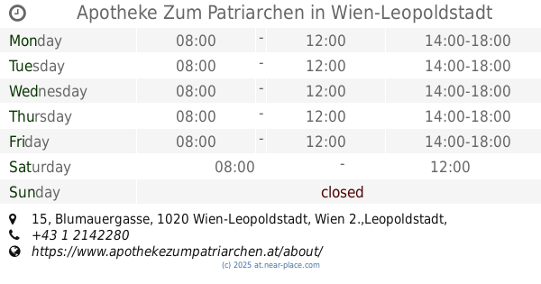
Apotheke Zum Patriarchen
Blumauergasse 15, Wien-Leopoldstadt
Pharmacy
read more
979 m
Mohren Apotheke
Wipplingerstraße 12, Wien
Pharmacy
read more
999 m
Schwan-Apotheke
Lessinggasse 23, Wien-Leopoldstadt
Pharmacy
read more
1.007 km
Herminen-Apotheke
Webergasse 1, Wien-Brigittenau
Pharmacy
read more
1.009 km
Bahnhof-Apotheke
Julius-Tandler-Platz 10, Wien
Pharmacy
read more
1.035 km
Pharmacy to St. Bridget
Wallensteinplatz 2, Wien
Pharmacy
read more
1.062 km
Apotheke Zur Austria
Währinger Straße 18, Wien
Pharmacy
read more
1.131 km
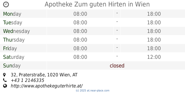
Apotheke Zum guten Hirten
Praterstraße 32, Wien
Pharmacy
read more
1.178 km
Apotheke "zur Hoffnung"
Heinestraße 37, Wien
Pharmacy
read more
📑
all categories
Accounting
Administrative area level 1
Administrative area level 2
Airport
Amusement park
Aquarium
Art gallery
Atm
Bakery
Bank
Bar
Beauty salon
Bicycle store
Book store
Bowling alley
Bus station
Cafe
Campground
Car dealer
Car rental
Car repair
Car wash
Casino
Cemetery
Church
City hall
Clothing store
Colloquial area
Convenience store
Country
Courthouse
Dentist
Department store
Doctor
Electrician
Electronics store
Embassy
Finance
Fire station
Florist
Food
Funeral home
Furniture store
Gas station
General contractor
Grocery or supermarket
Gym
Hair care
Hardware store
Health
Hindu Temple
Home goods store
Hospital
Insurance agency
Jewelry store
Laundry
Lawyer
Library
Light rail station
Liquor store
Local government office
Locality
Locksmith
Lodging
Meal delivery
Meal takeaway
Mosque
Movie rental
Movie theater
Moving company
Museum
Natural feature
Neighborhood
Night club
Painter
Park
Parking
Pet store
Pharmacy
Physiotherapist
Place of worship
Plumber
Point of interest
Police
Political
Post office
Premise
Real estate agency
Restaurant
Roofing contractor
Route
Rv park, camping
School
Shoe store
Shopping mall
Spa
Stadium
Storage
Store
Subpremise
Subway station
Supermarket
Synagogue
Taxi stand
Train station
Transit station
Travel agency
University
Veterinary care
Zoo
administrative area level 3
sublocality level 1
↑