Restaurant nearby ARIS Taverna.Ouserie
Austria
Restaurant nearby ARIS Taverna.Ouserie
ARIS Taverna.Ouserie
Mariahilfgasse 40, Linz Østrig
contacts phone
:
+43
Latitude:
48.3002153
, Longitude:
14.2745886
read more
nearest Restaurant
567 m
Wienerwald
Freinbergstraße 18, Linz
Restaurant
read more
783 m
Restaurant Cook
Klammstraße 1, Linz
Restaurant
read more
785 m
Schmid und Sunk Gaststättenbetriebs GesmbH
Waltherstraße 15, Linz
Restaurant
read more
802 m
Mac Olli's Hunger-Burg
Steingasse 9, Linz
Restaurant
read more
817 m
Schlosscafé
Schlossberg 1, Linz
Restaurant
read more
824 m
Barefoot Coffee & Bar Promenaden Galerien
Promenaden 25, Top 1, Linz
Restaurant
read more
824 m
Glorious Bastards
Promenade 25, Linz
Restaurant
read more
824 m
my Indigo Promenaden Galerien
Promenade 25, Linz
Restaurant
read more
834 m
Schlossbrasserie
Schlossberg 1a, Linz
Restaurant
read more
898 m
M.A.N.D.U. Lounge
Altstadt 16, Linz
Restaurant
read more
914 m
muto Restaurant
Altstadt 7, Linz
Restaurant
read more
930 m
Jindrak Pikant
Herrenstraße 24, Linz
Restaurant
read more
933 m
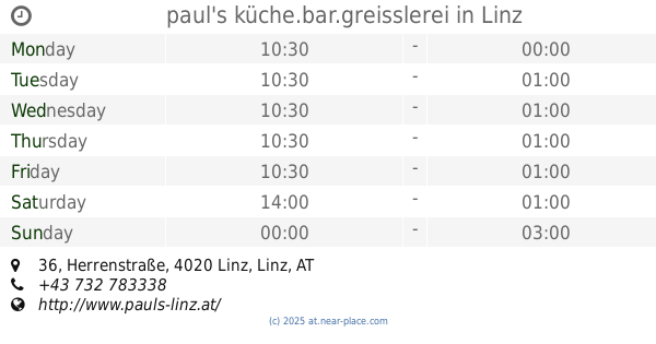
paul's küche.bar.greisslerei
Herrenstraße 36, Linz
Restaurant
read more
990 m
Rikscha Bistro Linz
Hofgasse 12, Linz
Restaurant
read more
1.002 km
Hu's Kitchen
12, Linz
Restaurant
read more
1.011 km
Burgerei
12, Linz
Restaurant
read more
1.013 km
Auersperg
Volksgartenstraße 1, Linz
Restaurant
read more
1.018 km
Göttfried
Hofgasse 5, Linz
Restaurant
read more
1.038 km
Pandana Thai Restaurant
Hauptplatz 23, Linz
Restaurant
read more
1.068 km
Biergartl an der Donau in Linz Urfahr
Fischergasse 17, Linz
Restaurant
read more
1.133 km
Alte Welt
Hauptplatz 4, Linz
Restaurant
read more
1.134 km
Fischerhäusl
Flußgasse 3, Linz
Restaurant
read more
1.15 km
Gösserkeller
Pfarrgasse 8, Linz
Restaurant
read more
1.173 km
Taco Buddies Restaurant
Adlergasse 6, Linz
Restaurant
read more
1.234 km
Eurest Restaurationsbetriebsgesellschaftm.b.H.
Adalbert-Stifter-Platz 2, Linz
Restaurant
read more
📑
all categories
Accounting
Administrative area level 1
Administrative area level 2
Airport
Amusement park
Aquarium
Art gallery
Atm
Bakery
Bank
Bar
Beauty salon
Bicycle store
Book store
Bowling alley
Bus station
Cafe
Campground
Car dealer
Car rental
Car repair
Car wash
Casino
Cemetery
Church
City hall
Clothing store
Colloquial area
Convenience store
Country
Courthouse
Dentist
Department store
Doctor
Electrician
Electronics store
Embassy
Finance
Fire station
Florist
Food
Funeral home
Furniture store
Gas station
General contractor
Grocery or supermarket
Gym
Hair care
Hardware store
Health
Hindu Temple
Home goods store
Hospital
Insurance agency
Jewelry store
Laundry
Lawyer
Library
Light rail station
Liquor store
Local government office
Locality
Locksmith
Lodging
Meal delivery
Meal takeaway
Mosque
Movie rental
Movie theater
Moving company
Museum
Natural feature
Neighborhood
Night club
Painter
Park
Parking
Pet store
Pharmacy
Physiotherapist
Place of worship
Plumber
Point of interest
Police
Political
Post office
Premise
Real estate agency
Restaurant
Roofing contractor
Route
Rv park, camping
School
Shoe store
Shopping mall
Spa
Stadium
Storage
Store
Subpremise
Subway station
Supermarket
Synagogue
Taxi stand
Train station
Transit station
Travel agency
University
Veterinary care
Zoo
administrative area level 3
sublocality level 1
↑