Restaurant nearby Casa Mia - Senf&Ketchup
Austria
Restaurant nearby Casa Mia - Senf&Ketchup
Casa Mia - Senf&Ketchup
Herrgottwiesgasse 97, Graz Østrig
contacts phone
:
+43
Latitude:
47.0498144
, Longitude:
15.4332248
read more
nearest Restaurant
173 m
Restaurant Fuxi Ding
Puchstraße 47, Graz
Restaurant
read more
173 m
Fuxi Ding
Puchstraße 47, Graz
Restaurant
read more
392 m
Venezia Pizzeria
Auf der Tändelwiese 22-24, Graz
Restaurant
read more
475 m
Mampf
Herrgottwiesgasse 51, Graz
Restaurant
read more
510 m
Hannelore Maria Kahr
Lagergasse 158, Graz
Restaurant
read more
515 m
McDonald's
Lauzilgasse 31, Graz
Restaurant
read more
527 m
Hochl & Co
Triester Straße 162, Graz
Restaurant
read more
714 m
Bon Appetit
Vinzenz-Muchitsch-Straße 10, Graz
Restaurant
read more
862 m
Don Benio
Kasernstraße 1, Graz
Restaurant
read more
868 m
De Mirci Kebap
Fröhlichgasse 83, Graz
Restaurant
read more
869 m
Pizza Bella
Kapellenstraße 43, Graz
Restaurant
read more
876 m
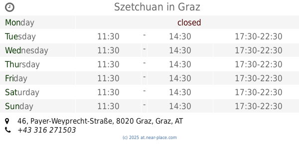
Szetchuan
Payer-Weyprecht-Straße 46, Graz
Restaurant
read more
940 m
Gasthaus Hochl
Alte Poststraße 344, Graz
Restaurant
read more
956 m
Da Vinci Pizza
Fröhlichgasse 73, Graz
Restaurant
read more
964 m
Pho Viet
Kapellenstraße 40, Graz
Restaurant
read more
1.014 km
Cetinkaya
Feldgasse 24, Graz
Restaurant
read more
1.066 km
Hendl+Co Imbiss
Schönaugürtel 34, Graz
Restaurant
read more
1.106 km
IFRI Imbiss
Schönaugasse 82, Graz
Restaurant
read more
1.592 km
Goldner Apfel 金苹果餐厅
Brockmanngasse 87, Graz
Restaurant
read more
1.661 km
Imbiss-Rainer
Conrad-von-Hötzendorf-Straße 12, Graz
Restaurant
read more
1.833 km
IM-NU Genussmanufaktur
Maygasse 4, Graz
Restaurant
read more
2.12 km
Bulan KEG
Reitschulgasse 17, Graz
Restaurant
read more
2.162 km
Wok City
Weblinger Gürtel 25, Graz
Restaurant
read more
2.163 km
Strindberg
Weblinger Gürtel 25, Graz
Restaurant
read more
2.303 km
Gösser Stüberl
Steyrergasse 1, Graz
Restaurant
read more
📑
all categories
Accounting
Administrative area level 1
Administrative area level 2
Airport
Amusement park
Aquarium
Art gallery
Atm
Bakery
Bank
Bar
Beauty salon
Bicycle store
Book store
Bowling alley
Bus station
Cafe
Campground
Car dealer
Car rental
Car repair
Car wash
Casino
Cemetery
Church
City hall
Clothing store
Colloquial area
Convenience store
Country
Courthouse
Dentist
Department store
Doctor
Electrician
Electronics store
Embassy
Finance
Fire station
Florist
Food
Funeral home
Furniture store
Gas station
General contractor
Grocery or supermarket
Gym
Hair care
Hardware store
Health
Hindu Temple
Home goods store
Hospital
Insurance agency
Jewelry store
Laundry
Lawyer
Library
Light rail station
Liquor store
Local government office
Locality
Locksmith
Lodging
Meal delivery
Meal takeaway
Mosque
Movie rental
Movie theater
Moving company
Museum
Natural feature
Neighborhood
Night club
Painter
Park
Parking
Pet store
Pharmacy
Physiotherapist
Place of worship
Plumber
Point of interest
Police
Political
Post office
Premise
Real estate agency
Restaurant
Roofing contractor
Route
Rv park, camping
School
Shoe store
Shopping mall
Spa
Stadium
Storage
Store
Subpremise
Subway station
Supermarket
Synagogue
Taxi stand
Train station
Transit station
Travel agency
University
Veterinary care
Zoo
administrative area level 3
sublocality level 1
↑