Restaurant nearby Gasthof Bauer
Austria
Restaurant nearby Gasthof Bauer
Gasthof Bauer
Josefgasse 7, Steyr Austria
contacts phone
:
+43
Latitude:
48.040627
, Longitude:
14.407698
read more
nearest Restaurant
407 m
Restaurant Kreta
Wehrgrabengasse 16, Steyr
Restaurant
read more
407 m
Schero Restaurantges.mbh
Wehrgrabengasse 16, Steyr
Restaurant
read more
409 m
Pizzeria Gabriel
Wehrgrabengasse 16, Steyr
Restaurant
read more
415 m
SINORAMA
Gaswerkgasse 16, Steyr
Restaurant
read more
687 m
Wirtshaus Knapp am Eck
Wehrgrabengasse 15, Steyr
Restaurant
read more
716 m
Orangerie im Schlosspark
Blumauergasse 1, Steyr
Restaurant
read more
814 m
Tex-Mex Restaurant
Stadtplatz 40, Steyr
Restaurant
read more
815 m
Pizzeria Diele am Berg Fam Sissa
Schlühslmayrstraße 81, Steyr
Restaurant
read more
829 m
Mao-Chu Chen
Stadtplatz 28, Steyr
Restaurant
read more
829 m
China - Restaurant Taiwan
Stadtplatz 28, Steyr
Restaurant
read more
857 m
Franz Anzenberger Gastronomie-Betriebsgesellschaft m.b.H.
Berggasse 2, Steyr
Restaurant
read more
866 m
Restaurant Pizzeria Aldo
Wolfernstraße 17, Steyr
Restaurant
read more
880 m
Akropolis Gastronomie GmbH
Grünmarkt 11, Steyr
Restaurant
read more
880 m
Restaurant- Galerie Reiner
Grünmarkt 11, Steyr
Restaurant
read more
886 m
Jin-cui KEG
Grünmarkt 15, Steyr
Restaurant
read more
886 m
Xiaowei Du
Grünmarkt 15, Steyr
Restaurant
read more
887 m
Würstelstand Weißengruber
Stadtplatz 25, Steyr
Restaurant
read more
893 m
Restaurant OLYMPIA
Stadtplatz 39, Steyr
Restaurant
read more
895 m
Restaurant Bräuhof
Stadtplatz 35, Steyr
Restaurant
read more
908 m
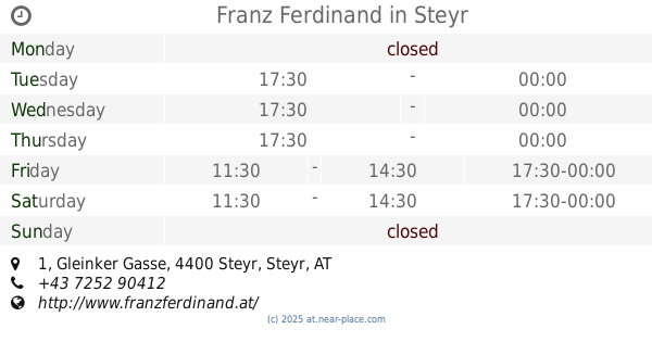
Franz Ferdinand
Gleinker Gasse 1, Steyr
Restaurant
read more
916 m
Xin - Xin
Enge Gasse 20, Steyr
Restaurant
read more
924 m
Restaurant Tadsch Mahal
Stadtplatz 37, Steyr
Restaurant
read more
924 m
Bar Central
Stadtplatz 37, Steyr
Restaurant
read more
947 m
Rahofer
Stadtplatz 9, Steyr
Restaurant
read more
1.208 km
Stadthalle Restaurant
Kaserngasse 6, Steyr
Restaurant
read more
📑
all categories
Accounting
Administrative area level 1
Administrative area level 2
Airport
Amusement park
Aquarium
Art gallery
Atm
Bakery
Bank
Bar
Beauty salon
Bicycle store
Book store
Bowling alley
Bus station
Cafe
Campground
Car dealer
Car rental
Car repair
Car wash
Casino
Cemetery
Church
City hall
Clothing store
Colloquial area
Convenience store
Country
Courthouse
Dentist
Department store
Doctor
Electrician
Electronics store
Embassy
Finance
Fire station
Florist
Food
Funeral home
Furniture store
Gas station
General contractor
Grocery or supermarket
Gym
Hair care
Hardware store
Health
Hindu Temple
Home goods store
Hospital
Insurance agency
Jewelry store
Laundry
Lawyer
Library
Light rail station
Liquor store
Local government office
Locality
Locksmith
Lodging
Meal delivery
Meal takeaway
Mosque
Movie rental
Movie theater
Moving company
Museum
Natural feature
Neighborhood
Night club
Painter
Park
Parking
Pet store
Pharmacy
Physiotherapist
Place of worship
Plumber
Point of interest
Police
Political
Post office
Premise
Real estate agency
Restaurant
Roofing contractor
Route
Rv park, camping
School
Shoe store
Shopping mall
Spa
Stadium
Storage
Store
Subpremise
Subway station
Supermarket
Synagogue
Taxi stand
Train station
Transit station
Travel agency
University
Veterinary care
Zoo
administrative area level 3
sublocality level 1
↑