Restaurant nearby Km2
Austria
Restaurant nearby Km2
Km2
Vienna Austria
contacts phone
:
+43
Latitude:
48.2091041
, Longitude:
16.415049
read more
nearest Restaurant
263 m
Krieauer Beisl
Krieau 248, Wien
Restaurant
read more
353 m
Vienna Cricket and Football-Club Restaurant
Meiereistraße 18, Wien
Restaurant
read more
353 m
Stögbauer&Zauner Gastronomie OG
Meiereistraße 18, Wien
Restaurant
read more
374 m
Würstelstand Stadion
Olympiaplatz W, Wien
Restaurant
read more
432 m
Citylake Asian Restaurant GmbH
Vorgartenstraße 206B, Wien
Restaurant
read more
502 m
Zum Burgenländer
Stadion Center, Olympiaplatz 2, Wien
Restaurant
read more
505 m
Don Camillo
Olympiaplatz 2, Wien
Restaurant
read more
520 m
DAS CAMPUS - Restaurant & Bar
Welthandelsplatz 1, Wien
Restaurant
read more
554 m
Stadium Kebab & Pizza
Olympiaplatz 2, Wien
Restaurant
read more
645 m
haltestelle1er
Rotundenallee 15, Wien
Restaurant
read more
651 m
1er Haltestelle
Rotundenallee 15, Wien
Restaurant
read more
757 m
Der Garten
Hauptallee, Wien
Restaurant
read more
780 m
die Allee
Hauptallee 124, Wien
Restaurant
read more
867 m
Paw Wok Bar
Vorgartenstraße 204, Wien
Restaurant
read more
886 m
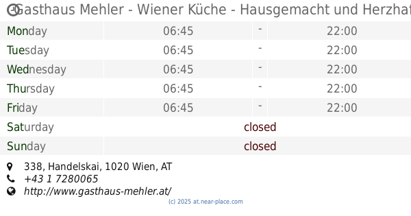
Gasthaus Mehler - Wiener Küche - Hausgemacht und Herzhaft
Handelskai 338, Wien
Restaurant
read more
899 m
Burger's Bar
204, Vorgartenstraße, Wien
Restaurant
read more
951 m
Estancia Santa Cruz
Prater Hauptallee 8, Wien
Restaurant
read more
968 m
Luftburg
128, Prater, Wien
Restaurant
read more
968 m
Kolarik Gastromonie Betriebsges. mbH
Prater 128, Wien
Restaurant
read more
995 m
L'Osteria Wien Wirtschaftsuni
Freudplatz 2, Wien
Restaurant
read more
1.009 km
Dinner in the Sky
Csardastraße 128, Wien
Restaurant
read more
1.066 km
Bocan & Bocan Gastronomiebetriebsgesmbh
Nordportalstraße 247, Wien
Restaurant
read more
1.145 km
McDonalds
Messestraße 100, Wien
Restaurant
read more
1.193 km
Prater Alm GmbH
Prater 71B, Wien
Restaurant
read more
1.254 km
Zur grünen Hütte
Prater 196, Wien
Restaurant
read more
📑
all categories
Accounting
Administrative area level 1
Administrative area level 2
Airport
Amusement park
Aquarium
Art gallery
Atm
Bakery
Bank
Bar
Beauty salon
Bicycle store
Book store
Bowling alley
Bus station
Cafe
Campground
Car dealer
Car rental
Car repair
Car wash
Casino
Cemetery
Church
City hall
Clothing store
Colloquial area
Convenience store
Country
Courthouse
Dentist
Department store
Doctor
Electrician
Electronics store
Embassy
Finance
Fire station
Florist
Food
Funeral home
Furniture store
Gas station
General contractor
Grocery or supermarket
Gym
Hair care
Hardware store
Health
Hindu Temple
Home goods store
Hospital
Insurance agency
Jewelry store
Laundry
Lawyer
Library
Light rail station
Liquor store
Local government office
Locality
Locksmith
Lodging
Meal delivery
Meal takeaway
Mosque
Movie rental
Movie theater
Moving company
Museum
Natural feature
Neighborhood
Night club
Painter
Park
Parking
Pet store
Pharmacy
Physiotherapist
Place of worship
Plumber
Point of interest
Police
Political
Post office
Premise
Real estate agency
Restaurant
Roofing contractor
Route
Rv park, camping
School
Shoe store
Shopping mall
Spa
Stadium
Storage
Store
Subpremise
Subway station
Supermarket
Synagogue
Taxi stand
Train station
Transit station
Travel agency
University
Veterinary care
Zoo
administrative area level 3
sublocality level 1
↑