Restaurant nearby Meißner Haus Alpenvereinshütte
Austria
Restaurant nearby Meißner Haus Alpenvereinshütte
Meißner Haus Alpenvereinshütte
Viggar 141, Ellbögen Austria
contacts phone
:
+43
Latitude:
47.2083531
, Longitude:
11.4883509
read more
nearest Restaurant
960 m
Almgasthaus Boscheben
Boscheben 172, Ellbögen
Restaurant
read more
2.042 km
Gipfelstube Patscherkofel
Patscherkofel, Patsch
Restaurant
read more
2.209 km
Sistranser Alm
Patscherkofel 1, Sistrans
Restaurant
read more
2.675 km
Lanser Alm
Patscherkofel 85, Lans
Restaurant
read more
2.783 km
Das Kofel
Gemeinde Patsch
Restaurant
read more
2.856 km
Gasthaus Hochmahdalm
Ellbögen 145, Patsch
Restaurant
read more
4.403 km
Gasthaus Glungezer
Oberdorf 27, Sistrans
Restaurant
read more
4.44 km
Bobcafe K14
Heiligwasserwiese 1a, Innsbruck
Restaurant
read more
4.854 km
La Fontana
Römerstraße 62, Igls / Innsbruck
Restaurant
read more
4.898 km
Restaurant Hausberg
Römerstraße 81, Innsbruck
Restaurant
read more
5.599 km
Landgasthof Pension Walzl
Dorfstraße 56, Lans
Restaurant
read more
5.761 km
VILLAGGIO7
Dorf 7, Aldrans
Restaurant
read more
6.876 km
Gluckserhütte
Tulferberg 57, Tulfes
Restaurant
read more
7.549 km
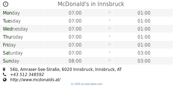
McDonald's
Amraser-See-Straße 56b, Innsbruck
Restaurant
read more
8.145 km
Restaurant Die Mühle
Gärberbach 2, Innsbruck
Restaurant
read more
8.424 km
CHiCCO‘S BURGER
Andechsstraße 61, Innsbruck
Restaurant
read more
9.138 km
Lunchhaus
Heiliggeiststraße 7, Innsbruck
Restaurant
read more
9.332 km
Milser Dorfstüberl
Kirchstraße 14, Mils
Restaurant
read more
9.393 km
Salam Restaurant
Sillgasse 12, Innsbruck
Restaurant
read more
9.635 km
Ginthers
Burggraben 4, Innsbruck
Restaurant
read more
9.889 km
Cammerlander Restaurants
Innrain 2, Innsbruck
Restaurant
read more
10.455 km
Ufo
Fürstenweg 69, Innsbruck
Restaurant
read more
10.947 km
Absam Burger
Frauental 1a, Absam
Restaurant
read more
11.336 km
walderbrücke
Absam
Restaurant
read more
11.941 km
Carlo's Ristolounge/pizzeria
-Hans-Gollner-Straße, Doktor-Hans-Gollner-Straße 1, Wattens
Restaurant
read more
📑
all categories
Accounting
Administrative area level 1
Administrative area level 2
Airport
Amusement park
Aquarium
Art gallery
Atm
Bakery
Bank
Bar
Beauty salon
Bicycle store
Book store
Bowling alley
Bus station
Cafe
Campground
Car dealer
Car rental
Car repair
Car wash
Casino
Cemetery
Church
City hall
Clothing store
Colloquial area
Convenience store
Country
Courthouse
Dentist
Department store
Doctor
Electrician
Electronics store
Embassy
Finance
Fire station
Florist
Food
Funeral home
Furniture store
Gas station
General contractor
Grocery or supermarket
Gym
Hair care
Hardware store
Health
Hindu Temple
Home goods store
Hospital
Insurance agency
Jewelry store
Laundry
Lawyer
Library
Light rail station
Liquor store
Local government office
Locality
Locksmith
Lodging
Meal delivery
Meal takeaway
Mosque
Movie rental
Movie theater
Moving company
Museum
Natural feature
Neighborhood
Night club
Painter
Park
Parking
Pet store
Pharmacy
Physiotherapist
Place of worship
Plumber
Point of interest
Police
Political
Post office
Premise
Real estate agency
Restaurant
Roofing contractor
Route
Rv park, camping
School
Shoe store
Shopping mall
Spa
Stadium
Storage
Store
Subpremise
Subway station
Supermarket
Synagogue
Taxi stand
Train station
Transit station
Travel agency
University
Veterinary care
Zoo
administrative area level 3
sublocality level 1
↑