Store nearby Kiosk
Austria
Store nearby Kiosk
Kiosk
Mölker Steig 1010, Wien Østrig
contacts phone
:
+43
Latitude:
48.2128066
, Longitude:
16.3633006
read more
nearest Store
196 m
mag kottas
Freyung, Wien
Store
read more
501 m
Easy Business Training GmbH
Günthergasse 3, Wien
Store
read more
560 m
Connecting World
Währinger Straße 9, Wien
Store
read more
603 m
Spanish Riding School Gift Shop
Michaelerplatz 1, Wien
Store
read more
618 m
Tabak Trafik
Florianigasse 2, Wien
Store
read more
647 m
Safran Cie Texstil
Werdertorgasse 12, Wien
Store
read more
667 m
Hans Trimmel
Wildpretmarkt 1, Wien
Store
read more
685 m
City-Antik Oliver Hunter
Stallburggasse 4, Wien
Store
read more
700 m
Maria Rossnegger
Marc-Aurel-Straße 3, Wien
Store
read more
704 m
Media4Equity Invest
Liechtensteinstraße 25, Wien
Store
read more
736 m
Vom Fass Wien
Brandstätte 5, Wien
Store
read more
758 m
Cuckoo Clocks Shop
Jasomirgottstraße 4, Wien
Store
read more
772 m
Desider Goldberger
Hoher Markt 1, Wien
Store
read more
797 m
World of Souvenirs
Stephansplatz 8, Wien
Store
read more
819 m
The Body Shop
Rotenturmstraße 5-9, Wien
Store
read more
836 m
Pearle-Optik
Rotenturmstraße 2, Wien
Store
read more
885 m
Mojan Gonzi
Stephansplatz 3, Wien
Store
read more
917 m
RIMOWA Store Wien
Neuer Markt 2, Wien
Store
read more
932 m
Ihre Brille Augenoptik
Wollzeile 4, Wien
Store
read more
944 m
Steffl Accessoire Floor
Kärntner Straße 19, Wien
Store
read more
1.01 km
LIBRO Handelsgesellschaft mbH
Wollzeile 13, Wien
Store
read more
1.014 km
Bergsport Schwanda
Bäckerstraße 7, Wien
Store
read more
1.028 km
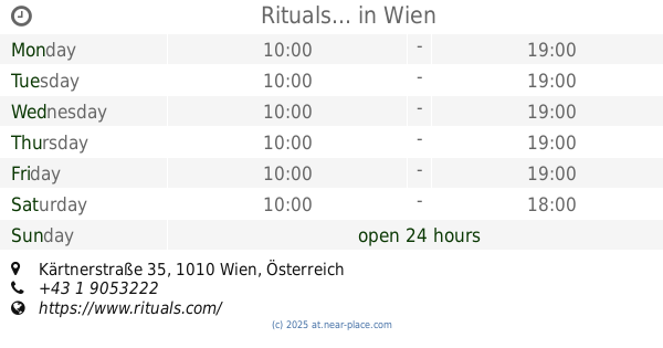
Rituals...
Wien, Kärtnerstraße 35
Store
read more
1.058 km
SONNENTOR Wien-Wollzeile
Wollzeile 14, Wien
Store
read more
1.08 km
Sacher Confiserie Vienna
Philharmoniker Straße 4, Wien
Store
read more
📑
all categories
Accounting
Administrative area level 1
Administrative area level 2
Airport
Amusement park
Aquarium
Art gallery
Atm
Bakery
Bank
Bar
Beauty salon
Bicycle store
Book store
Bowling alley
Bus station
Cafe
Campground
Car dealer
Car rental
Car repair
Car wash
Casino
Cemetery
Church
City hall
Clothing store
Colloquial area
Convenience store
Country
Courthouse
Dentist
Department store
Doctor
Electrician
Electronics store
Embassy
Finance
Fire station
Florist
Food
Funeral home
Furniture store
Gas station
General contractor
Grocery or supermarket
Gym
Hair care
Hardware store
Health
Hindu Temple
Home goods store
Hospital
Insurance agency
Jewelry store
Laundry
Lawyer
Library
Light rail station
Liquor store
Local government office
Locality
Locksmith
Lodging
Meal delivery
Meal takeaway
Mosque
Movie rental
Movie theater
Moving company
Museum
Natural feature
Neighborhood
Night club
Painter
Park
Parking
Pet store
Pharmacy
Physiotherapist
Place of worship
Plumber
Point of interest
Police
Political
Post office
Premise
Real estate agency
Restaurant
Roofing contractor
Route
Rv park, camping
School
Shoe store
Shopping mall
Spa
Stadium
Storage
Store
Subpremise
Subway station
Supermarket
Synagogue
Taxi stand
Train station
Transit station
Travel agency
University
Veterinary care
Zoo
administrative area level 3
sublocality level 1
↑