Store nearby MEGAFIT-Store
Austria
Store nearby MEGAFIT-Store
MEGAFIT-Store
69, Lustenauer Straße, Dornbirn Austria
contacts phone
:
+43
Latitude:
47.4100334
, Longitude:
9.7225413
read more
nearest Store
143 m
MAREL IT solutions
Härte 2, Dornbirn
Store
read more
394 m
Druckerei Sedlmayr GmbH & Co KG
Lustenauer Straße 79, Dornbirn
Store
read more
434 m
Josef Mäser GmbH
Roßmähder 9, Dornbirn
Store
read more
528 m
Hellotracks
Heimried 3, Dornbirn
Store
read more
611 m
Dragan Vasic
Heinzenbeer 34, Dornbirn
Store
read more
766 m
Andrea Forster
Bildgasse 16, Dornbirn
Store
read more
780 m
Werner Prügger
Bäumlegasse 12, Dornbirn
Store
read more
812 m
d.i.s. display- & ausstellungsbau gmbh
Jodok-Stülz-Weg 15a, Dornbirn
Store
read more
832 m
Swatch
Messestraße 2, Dornbirn
Store
read more
832 m
Swatch Store
Messestraße 2, Dornbirn
Store
read more
851 m
Tabak Trafik
Messestraße 2, Dornbirn
Store
read more
858 m
O.Rein
Messestraße 2, Dornbirn
Store
read more
861 m
The Body Shop
Messepark, Messestrasse 2, Dornbirn
Store
read more
862 m
Scharax Optik
Dornbirn, Messestraße 2 Einkaufszentrum Messepark
Store
read more
868 m
Desigual D - Shop
Messestraße 2, Dornbirn
Store
read more
868 m
dm drogerie markt GmbH
Messestraße 2, Dornbirn
Store
read more
868 m
Claire's Austria GmbH
Messestraße 2, Dornbirn
Store
read more
886 m
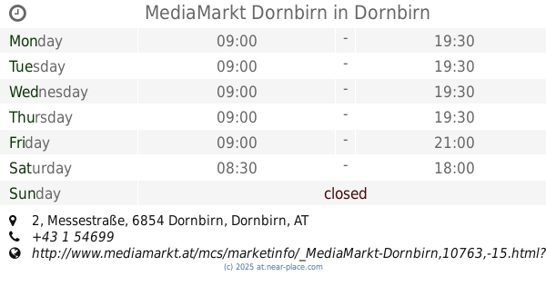
MediaMarkt Dornbirn
Messestraße 2, Dornbirn
Store
read more
891 m
Heinz Jeans Inh. Claudia Wadl e.U.
Messestraße 2, Dornbirn
Store
read more
893 m
T-Mobile Shop
Messestraße 2, Dornbirn
Store
read more
899 m
Nanu - Nana
Messestraße 2, Dornbirn
Store
read more
1.003 km
Collection 2000
Moosmahdstraße 19a, Dornbirn
Store
read more
1.014 km
Hildegard Gmeiner
Moosmahdstraße 28, Dornbirn
Store
read more
1.069 km
Adhesive Dämmsysteme GmbH
Bildgasse 8, Dornbirn
Store
read more
1.36 km
Martin Fink
Hatlerstraße 35, Dornbirn
Store
read more
📑
all categories
Accounting
Administrative area level 1
Administrative area level 2
Airport
Amusement park
Aquarium
Art gallery
Atm
Bakery
Bank
Bar
Beauty salon
Bicycle store
Book store
Bowling alley
Bus station
Cafe
Campground
Car dealer
Car rental
Car repair
Car wash
Casino
Cemetery
Church
City hall
Clothing store
Colloquial area
Convenience store
Country
Courthouse
Dentist
Department store
Doctor
Electrician
Electronics store
Embassy
Finance
Fire station
Florist
Food
Funeral home
Furniture store
Gas station
General contractor
Grocery or supermarket
Gym
Hair care
Hardware store
Health
Hindu Temple
Home goods store
Hospital
Insurance agency
Jewelry store
Laundry
Lawyer
Library
Light rail station
Liquor store
Local government office
Locality
Locksmith
Lodging
Meal delivery
Meal takeaway
Mosque
Movie rental
Movie theater
Moving company
Museum
Natural feature
Neighborhood
Night club
Painter
Park
Parking
Pet store
Pharmacy
Physiotherapist
Place of worship
Plumber
Point of interest
Police
Political
Post office
Premise
Real estate agency
Restaurant
Roofing contractor
Route
Rv park, camping
School
Shoe store
Shopping mall
Spa
Stadium
Storage
Store
Subpremise
Subway station
Supermarket
Synagogue
Taxi stand
Train station
Transit station
Travel agency
University
Veterinary care
Zoo
administrative area level 3
sublocality level 1
↑