Supermarket nearby BILLA AG
Austria
Supermarket nearby BILLA AG
BILLA AG
Beingasse 30, Wien Österreich
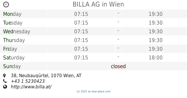
contacts phone
:
+43
Latitude:
48.1999521
, Longitude:
16.3321503
read more
nearest Supermarket
139 m
HOFER Wien 15., Rudolfsh/Fünfhaus
Hütteldorfer Straße 39-41, Wien 15., Rudolfsh/Fünfhaus
Supermarket
read more
330 m
SE&PAS Supermarkt
Schweglerstraße 32, Wien
Supermarket
read more
453 m
Lidl
Stättermayergasse 15, Wien
Supermarket
read more
462 m
BILLA AG
Neubaugürtel 38, Wien
Supermarket
read more
504 m
SPAR
Camillo-Sitte-Gasse 6, Wien
Supermarket
read more
530 m
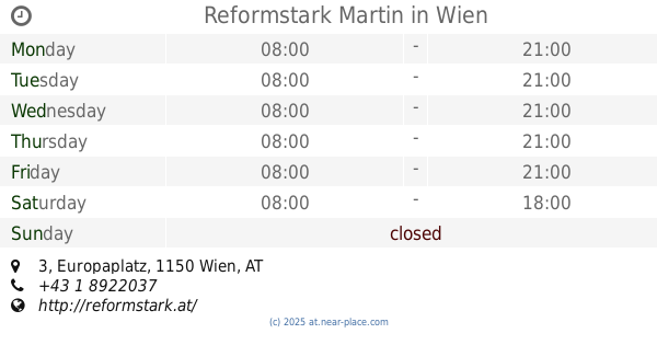
Reformstark Martin
BahnhofCity Wien West, Europaplatz 3, Wien
Supermarket
read more
562 m
Prosi latino
Kandlgasse 46, Wien
Supermarket
read more
563 m
Mehmet Koc KEG
Gablenzgasse 4, Wien
Supermarket
read more
593 m
BILLA AG
Hütteldorfer Straße 73, Wien
Supermarket
read more
603 m
Merkur
Mariahilfer Gürtel 2, Wien
Supermarket
read more
619 m
U3 Supermarkt
Vienna
Supermarket
read more
676 m
PENNY Markt
Mariahilfer Straße 135, Wien
Supermarket
read more
677 m
The Market Mariahilf
Mariahilfer Straße 137, Wien
Supermarket
read more
785 m
Billa AG
Mariahilfer Straße 120, Wien
Supermarket
read more
824 m
HOFER
Mariahilfer Straße 123, Wien
Supermarket
read more
824 m
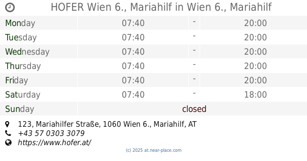
HOFER Wien 6., Mariahilf
Mariahilfer Straße 123, Wien 6., Mariahilf
Supermarket
read more
839 m
Billa AG
Kaiserstraße 91, Wien
Supermarket
read more
923 m
HOFER
Kaiserstraße 92, Wien
Supermarket
read more
935 m
SPAR
Schottenfeldgasse 66, Wien
Supermarket
read more
938 m
EUROSPAR
Hütteldorfer Straße 81B, Wien
Supermarket
read more
939 m
MaranVEGAN GmbH
Stumpergasse 57, Wien
Supermarket
read more
980 m
BILLA
Mariahilfer Straße 186-188, Wien
Supermarket
read more
991 m
PENNY Markt
Kreitnergasse 1-3, Wien
Supermarket
read more
1000 m
BILLA AG
Mariahilfer Straße 188, Wien
Supermarket
read more
1.244 km
PENNY Markt
Koppstraße 84, Wien
Supermarket
read more
📑
all categories
Accounting
Administrative area level 1
Administrative area level 2
Airport
Amusement park
Aquarium
Art gallery
Atm
Bakery
Bank
Bar
Beauty salon
Bicycle store
Book store
Bowling alley
Bus station
Cafe
Campground
Car dealer
Car rental
Car repair
Car wash
Casino
Cemetery
Church
City hall
Clothing store
Colloquial area
Convenience store
Country
Courthouse
Dentist
Department store
Doctor
Electrician
Electronics store
Embassy
Finance
Fire station
Florist
Food
Funeral home
Furniture store
Gas station
General contractor
Grocery or supermarket
Gym
Hair care
Hardware store
Health
Hindu Temple
Home goods store
Hospital
Insurance agency
Jewelry store
Laundry
Lawyer
Library
Light rail station
Liquor store
Local government office
Locality
Locksmith
Lodging
Meal delivery
Meal takeaway
Mosque
Movie rental
Movie theater
Moving company
Museum
Natural feature
Neighborhood
Night club
Painter
Park
Parking
Pet store
Pharmacy
Physiotherapist
Place of worship
Plumber
Point of interest
Police
Political
Post office
Premise
Real estate agency
Restaurant
Roofing contractor
Route
Rv park, camping
School
Shoe store
Shopping mall
Spa
Stadium
Storage
Store
Subpremise
Subway station
Supermarket
Synagogue
Taxi stand
Train station
Transit station
Travel agency
University
Veterinary care
Zoo
administrative area level 3
sublocality level 1
↑