Supermarket nearby BILLA AG
Coronavirus disease (COVID-19) Situation
confirmed cases
6081287
deaths
22542
Austria
Supermarket nearby BILLA AG
BILLA AG
6, Singerstraße, 1010, Wien, AT Österreich
contacts phone
:
+43 1 5132579
website:
www.billa.at
Latitude:
48.2075995
, Longitude:
16.3726592
larger map & directions
read more
nearest Supermarket
148 m
BILLA AG
Neuer Markt 17, Herrnhut
Supermarket
read more
457 m
SPAR Szupermarket
Fleischmarkt 5, Wien
Supermarket
read more
461 m
SPAR
Wollzeile 39, Wien
Supermarket
read more
461 m
SPAR Szupermarket
Wollzeile 39, Wien
Supermarket
read more
534 m
BILLA AG
Franz-Josefs-Kai 29, Wien
Supermarket
read more
545 m
SPAR Gourmet
Vorlaufstraße 3, Wien
Supermarket
read more
545 m
SPAR
Vorlaufstraße 3, Wien
Supermarket
read more
547 m
SPAR
Parkring 2, Wien
Supermarket
read more
578 m
jägerTEE
Operngasse 6, Wien
Supermarket
read more
602 m
Billa Corso
Kärntner Ring 9-13, MAHLER
Supermarket
read more
716 m
Billa
Biberstraße 15, Wien
Supermarket
read more
730 m
HOFER Vienna,Inner City
Neutorgasse 2, Wien
Supermarket
read more
730 m
HOFER Wien 1., Innere Stadt
Neutorgasse 2, Wien
Supermarket
read more
730 m
HOFER
Neutorgasse 2, Wien
Supermarket
read more
809 m
BILLA AG
Schottengasse 1, Wien
Supermarket
read more
858 m
BILLA AG
Taborstraße 8A, Wien
Supermarket
read more
924 m
SPAR
Schottengasse 7, Wien
Supermarket
read more
931 m
Reformstark Martin
Landstraßer Hauptstraße 1B, Einkaufszentrum The Mall, Wien
Supermarket
read more
992 m
SPAR Gourmet
Salesianergasse 1 B, Wien
Supermarket
read more
1.012 km
SPAR
Hollandstraße 11, Wien
Supermarket
read more
1.074 km
SPAR
Praterstraße 25, Wien
Supermarket
read more
1.13 km
BILLA AG
Rechte Wienzeile 9, Wien
Supermarket
read more
1.222 km
BILLA AG
Czerningasse 4, Wien
Supermarket
read more
1.255 km
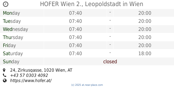
HOFER Wien 2., Leopoldstadt
Zirkusgasse 24, Wien
Supermarket
read more
1.255 km
HOFER
Zirkusgasse 24, Wien
Supermarket
read more
📑
all categories
Accounting
Administrative area level 1
Administrative area level 2
Airport
Amusement park
Aquarium
Art gallery
Atm
Bakery
Bank
Bar
Beauty salon
Bicycle store
Book store
Bowling alley
Bus station
Cafe
Campground
Car dealer
Car rental
Car repair
Car wash
Casino
Cemetery
Church
City hall
Clothing store
Colloquial area
Convenience store
Country
Courthouse
Dentist
Department store
Doctor
Electrician
Electronics store
Embassy
Finance
Fire station
Florist
Food
Funeral home
Furniture store
Gas station
General contractor
Grocery or supermarket
Gym
Hair care
Hardware store
Health
Hindu Temple
Home goods store
Hospital
Insurance agency
Jewelry store
Laundry
Lawyer
Library
Light rail station
Liquor store
Local government office
Locality
Locksmith
Lodging
Meal delivery
Meal takeaway
Mosque
Movie rental
Movie theater
Moving company
Museum
Natural feature
Neighborhood
Night club
Painter
Park
Parking
Pet store
Pharmacy
Physiotherapist
Place of worship
Plumber
Point of interest
Police
Political
Post office
Premise
Real estate agency
Restaurant
Roofing contractor
Route
Rv park, camping
School
Shoe store
Shopping mall
Spa
Stadium
Storage
Store
Subpremise
Subway station
Supermarket
Synagogue
Taxi stand
Train station
Transit station
Travel agency
University
Veterinary care
Zoo
administrative area level 3
sublocality level 1
↑