Supermarket nearby BILLA AG
Austria
Supermarket nearby BILLA AG
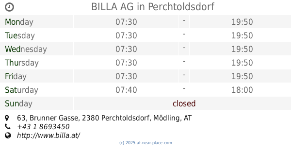
BILLA AG
Willergasse 24, Wien Österreich
contacts phone
:
+43
Latitude:
48.133837
, Longitude:
16.2566287
read more
nearest Supermarket
242 m
SPAR
Ketzergasse 455, Wien
Supermarket
read more
966 m
Wien elisestrasse
Elisenstraße, Wien
Supermarket
read more
1.209 km
BILLA AG
Donauwörther Straße 46, Perchtoldsdorf
Supermarket
read more
1.242 km
Eurospar
Kaltenleutgebner Straße 1230, Wien
Supermarket
read more
1.668 km
Merkur Markt
Breitenfurter Straße 372, Wien
Supermarket
read more
1.733 km
PENNY Markt
Donauwörther Straße 26-30, Perchtoldsdorf
Supermarket
read more
1.801 km
BILLA AG
Geßlgasse 19, Wien
Supermarket
read more
1.863 km
SPAR Gourmet
Marktplatz 19, Perchtoldsdorf
Supermarket
read more
1.967 km
BILLA AG
Franz-Parsche-Gasse 6, Wien
Supermarket
read more
2.047 km
SPAR
Maurer Hauptplatz 7, Wien
Supermarket
read more
2.29 km
HOFER
Brunner Gasse 46, Perchtoldsdorf
Supermarket
read more
2.29 km
HOFER Perchtoldsdorf
Brunner Gasse 46, Perchtoldsdorf
Supermarket
read more
2.492 km
BILLA AG
Mehlführergasse 30, Wien
Supermarket
read more
2.501 km
BILLA AG
Breitenfurter Straße 324, Wien
Supermarket
read more
2.556 km
BILLA AG
Brunner Gasse 63, Perchtoldsdorf
Supermarket
read more
2.63 km
Lidl
Leopold Gattringer-Straße 115-117, Brunn am Gebirge
Supermarket
read more
2.708 km
EUROSPAR
Mühlgasse 92, Perchtoldsdorf
Supermarket
read more
2.726 km
BILLA AG
Ketzergasse 191, Perchtoldsdorf
Supermarket
read more
2.729 km
PENNY Markt
Knotzenbachgasse 40, Wien
Supermarket
read more
2.895 km
ETSAN Supermarkt
Breitenfurter Straße 323, Wien
Supermarket
read more
2.906 km
HOFER Perchtoldsdorf
Mühlgasse 98, Perchtoldsdorf
Supermarket
read more
2.906 km
HOFER
Mühlgasse 98, Perchtoldsdorf
Supermarket
read more
3.124 km
EUROSPAR
Gatterederstraße 17, Wien
Supermarket
read more
3.211 km
HOFER Wien 23., Liesing
Gatterederstraße 11-15, Wien
Supermarket
read more
3.304 km
BILLA AG
Breitenfurter Straße 234, Wien
Supermarket
read more
📑
all categories
Accounting
Administrative area level 1
Administrative area level 2
Airport
Amusement park
Aquarium
Art gallery
Atm
Bakery
Bank
Bar
Beauty salon
Bicycle store
Book store
Bowling alley
Bus station
Cafe
Campground
Car dealer
Car rental
Car repair
Car wash
Casino
Cemetery
Church
City hall
Clothing store
Colloquial area
Convenience store
Country
Courthouse
Dentist
Department store
Doctor
Electrician
Electronics store
Embassy
Finance
Fire station
Florist
Food
Funeral home
Furniture store
Gas station
General contractor
Grocery or supermarket
Gym
Hair care
Hardware store
Health
Hindu Temple
Home goods store
Hospital
Insurance agency
Jewelry store
Laundry
Lawyer
Library
Light rail station
Liquor store
Local government office
Locality
Locksmith
Lodging
Meal delivery
Meal takeaway
Mosque
Movie rental
Movie theater
Moving company
Museum
Natural feature
Neighborhood
Night club
Painter
Park
Parking
Pet store
Pharmacy
Physiotherapist
Place of worship
Plumber
Point of interest
Police
Political
Post office
Premise
Real estate agency
Restaurant
Roofing contractor
Route
Rv park, camping
School
Shoe store
Shopping mall
Spa
Stadium
Storage
Store
Subpremise
Subway station
Supermarket
Synagogue
Taxi stand
Train station
Transit station
Travel agency
University
Veterinary care
Zoo
administrative area level 3
sublocality level 1
↑