Supermarket nearby EUROSPAR
Coronavirus disease (COVID-19) Situation
confirmed cases
6081287
deaths
22542
Austria
Supermarket nearby EUROSPAR
EUROSPAR
Schmierndorferstraße 35, Wels Austria
contacts phone
:
+43
Latitude:
48.1584094
, Longitude:
14.0004143
read more
nearest Supermarket
230 m
HOFER
Wimpassinger Straße 1, Wels
Supermarket
read more
230 m
HOFER Wels
Wimpassinger Straße 1, Wels
Supermarket
read more
412 m
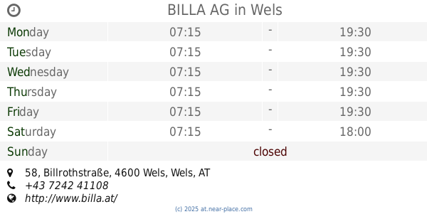
BILLA AG
Billrothstraße 58, Wels
Supermarket
read more
415 m
DHL-Abholung Packet Dienst.
Billrothstraße 58, Wels
Supermarket
read more
470 m
Unimarkt
Lindenstraße 7, Wels
Supermarket
read more
470 m
UNIMARKT Handelsgesellschaft m.b.H. & Co. Kommanditgesellschaft
Lindenstraße 7, Wels
Supermarket
read more
563 m
Basak GesmbH
Dragonerstraße 72, Wels
Supermarket
read more
586 m
Anadolu Supermarket e.U.
Camillo-Schulz-Straße 51, Wels
Supermarket
read more
789 m
SPAR
Römerstraße 148, Wels
Supermarket
read more
794 m
NORMA Filiale
Salzburger Straße 149, Wels
Supermarket
read more
865 m
BILLA
Maria-Theresia-Straße 55, Wels
Supermarket
read more
866 m
BILLA AG
Maria-Theresia-Straße 55, Wels
Supermarket
read more
873 m
DHL-Abholung Paket Dienst
Maria-Theresia-Straße 55, Wels
Supermarket
read more
1.074 km
HOFER Wels
Römerstraße 142, Wels
Supermarket
read more
1.133 km
PENNY Markt
Eiselbergstraße 4, Wels
Supermarket
read more
1.235 km
BILLA AG
Carl-Richter-Straße 2, Wels
Supermarket
read more
1.256 km
NORMA Filiale
Salzburger Straße 27, Wels
Supermarket
read more
1.297 km
SPAR
Vogelweiderstraße 9, Wels
Supermarket
read more
1.297 km
SPAR Perspektive Handel Caritas gGmbH
Vogelweiderstraße 9, Wels
Supermarket
read more
1.369 km
Norma
Föhrenstraße 20, Wels
Supermarket
read more
1.402 km
EUROSPAR
Europastraße 60, Wels
Supermarket
read more
1.712 km
UNIMARKT Handelsgesellschaft m.b.H. & Co. Kommanditgesellschaft
Ringstraße 21, Wels
Supermarket
read more
1.914 km
NORMA Filiale
Oberfeldstraße 58, Wels
Supermarket
read more
1.93 km
Reformstark Martin
Stadtplatz 15, Wels
Supermarket
read more
2.155 km
Spar
Grieskirchner Straße 9, Wels
Supermarket
read more
📑
all categories
Accounting
Administrative area level 1
Administrative area level 2
Airport
Amusement park
Aquarium
Art gallery
Atm
Bakery
Bank
Bar
Beauty salon
Bicycle store
Book store
Bowling alley
Bus station
Cafe
Campground
Car dealer
Car rental
Car repair
Car wash
Casino
Cemetery
Church
City hall
Clothing store
Colloquial area
Convenience store
Country
Courthouse
Dentist
Department store
Doctor
Electrician
Electronics store
Embassy
Finance
Fire station
Florist
Food
Funeral home
Furniture store
Gas station
General contractor
Grocery or supermarket
Gym
Hair care
Hardware store
Health
Hindu Temple
Home goods store
Hospital
Insurance agency
Jewelry store
Laundry
Lawyer
Library
Light rail station
Liquor store
Local government office
Locality
Locksmith
Lodging
Meal delivery
Meal takeaway
Mosque
Movie rental
Movie theater
Moving company
Museum
Natural feature
Neighborhood
Night club
Painter
Park
Parking
Pet store
Pharmacy
Physiotherapist
Place of worship
Plumber
Point of interest
Police
Political
Post office
Premise
Real estate agency
Restaurant
Roofing contractor
Route
Rv park, camping
School
Shoe store
Shopping mall
Spa
Stadium
Storage
Store
Subpremise
Subway station
Supermarket
Synagogue
Taxi stand
Train station
Transit station
Travel agency
University
Veterinary care
Zoo
administrative area level 3
sublocality level 1
↑