Supermarket nearby HOFER
Austria
Supermarket nearby HOFER
HOFER
Am Tabor 42 - 44 Wien 2 Österreich
contacts phone
:
+43
Latitude:
48.225264
, Longitude:
16.3872451
read more
nearest Supermarket
HOFER Wien 2., Leopoldstadt
Am Tabor 42 - 44 Wien 2
Supermarket
read more
298 m
SPAR
Taborstraße 87, Wien
Supermarket
read more
480 m
Hofer
Am Tabor 42 - 44, Wien
Supermarket
read more
629 m
HOFER Wien 20., Brigittenau
Nordwestbahnstraße 8-10, Wien
Supermarket
read more
629 m
Hofer
Nordwestbahnstraße 8-10, Wien
Supermarket
read more
635 m
Lidl Österreich GmbH
Heinestraße 24-28, Wien
Supermarket
read more
644 m
PENNY Markt
Josefinengasse 2, Wien
Supermarket
read more
778 m
Billa AG
Walcherstraße 11, Wien
Supermarket
read more
836 m
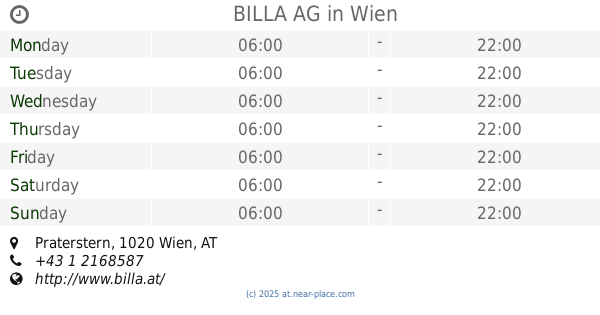
BILLA AG
Praterstern, Wien
Supermarket
read more
840 m
OKAY Reiseproviant
U-Bahn Station,, Praterstern, Wien
Supermarket
read more
840 m
SPAR Gourmet
Taborstraße 40, Wien
Supermarket
read more
882 m
HOFER Wien 2., Leopoldstadt
Engerthstraße, Leopoldstadt 154A, Wien
Supermarket
read more
885 m
Chinesischer Markt, 1-Euro-Shop
Lassallestraße 16, Wien
Supermarket
read more
885 m
Rotensterngasse
Rotensterngasse 21, Wien
Supermarket
read more
898 m
ETSAN Supermarket
Engerthstraße 148-150, Wien
Supermarket
read more
906 m
BILLA AG
Rotensterngasse 21-23, Wien
Supermarket
read more
959 m
BILLA AG
Vorgartenstraße 107, Wien
Supermarket
read more
966 m
EUROSPAR
Vorgartenstraße 134-138, Wien
Supermarket
read more
992 m
Nah&Frischpunkt
Lassallestraße 11, Wien
Supermarket
read more
1.023 km
BILLA AG
Stuwerstraße 1-3, Wien
Supermarket
read more
1.031 km
Supermari'
Leopoldsgasse 22, Wien
Supermarket
read more
1.082 km
Penny Markt
Ausstellungsstraße 1, Wien
Supermarket
read more
1.099 km
Lidl
Wallensteinstraße 55, Wien
Supermarket
read more
1.099 km
Lidl Österreich GmbH
Wallensteinstraße 55, Wien
Supermarket
read more
1.117 km
زهور الشام للمواد الغذائية
Wallensteinstraße 56, Wien
Supermarket
read more
📑
all categories
Accounting
Administrative area level 1
Administrative area level 2
Airport
Amusement park
Aquarium
Art gallery
Atm
Bakery
Bank
Bar
Beauty salon
Bicycle store
Book store
Bowling alley
Bus station
Cafe
Campground
Car dealer
Car rental
Car repair
Car wash
Casino
Cemetery
Church
City hall
Clothing store
Colloquial area
Convenience store
Country
Courthouse
Dentist
Department store
Doctor
Electrician
Electronics store
Embassy
Finance
Fire station
Florist
Food
Funeral home
Furniture store
Gas station
General contractor
Grocery or supermarket
Gym
Hair care
Hardware store
Health
Hindu Temple
Home goods store
Hospital
Insurance agency
Jewelry store
Laundry
Lawyer
Library
Light rail station
Liquor store
Local government office
Locality
Locksmith
Lodging
Meal delivery
Meal takeaway
Mosque
Movie rental
Movie theater
Moving company
Museum
Natural feature
Neighborhood
Night club
Painter
Park
Parking
Pet store
Pharmacy
Physiotherapist
Place of worship
Plumber
Point of interest
Police
Political
Post office
Premise
Real estate agency
Restaurant
Roofing contractor
Route
Rv park, camping
School
Shoe store
Shopping mall
Spa
Stadium
Storage
Store
Subpremise
Subway station
Supermarket
Synagogue
Taxi stand
Train station
Transit station
Travel agency
University
Veterinary care
Zoo
administrative area level 3
sublocality level 1
↑