Supermarket nearby HOFER Langenzersdorf
Austria
Supermarket nearby HOFER Langenzersdorf
HOFER Langenzersdorf
Wiener Straße 210-218, Langenzersdorf Austria
contacts phone
:
+43
Latitude:
48.2971025
, Longitude:
16.3751022
read more
nearest Supermarket
17 m
HOFER
Wiener Straße 210-218, Langenzersdorf
Supermarket
read more
169 m
PENNY Markt
FMZ C21, Prager Straße 286, Wien
Supermarket
read more
219 m
BILLA AG
Prager Straße 286, Wien
Supermarket
read more
384 m
Lidl
Meisengasse 8, Langenzersdorf
Supermarket
read more
701 m
SPAR
Wiener Straße 138, Langenzersdorf
Supermarket
read more
914 m
BILLA AG
Meriangasse 3, Wien
Supermarket
read more
1.273 km
BILLA AG
Prager Straße 274, Wien
Supermarket
read more
1.872 km
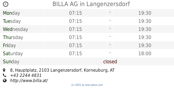
BILLA AG
Hauptplatz 8, Langenzersdorf
Supermarket
read more
2.569 km
HOFER Klosterneuburg
Schüttaustr. 5-7, Klosterneuburg
Supermarket
read more
2.569 km
HOFER
Schüttaustr. 5-7, Klosterneuburg
Supermarket
read more
2.588 km
Das Futterhaus
Wiener Straße 53, Klosterneuburg
Supermarket
read more
2.683 km
Merkur Markt
Aufeldgasse 45-49, Klosterneuburg
Supermarket
read more
2.7 km
Lidl
Aufeldgasse 53, Klosterneuburg
Supermarket
read more
3.256 km
BILLA AG
Prager Straße 82-86, Wien
Supermarket
read more
3.479 km
INTERSPAR
Trillergasse 4, Wien
Supermarket
read more
3.747 km
HOFER
Shuttleworthstraße 11, Wien 21., Floridsdorf
Supermarket
read more
3.818 km
BILLA AG
Brünner Straße 57D, Wien
Supermarket
read more
3.985 km
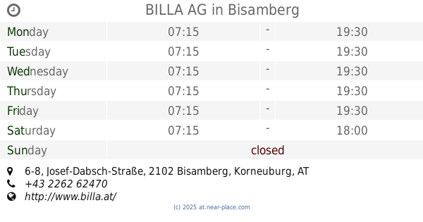
BILLA AG
Josef-Dabsch-Straße 6-8, Bisamberg
Supermarket
read more
4.03 km
HOFER Klosterneuburg-Weidling
Brandmayerstraße 38-48
Supermarket
read more
4.592 km
Lidl
Brünner Straße 10, Wien
Supermarket
read more
4.771 km
INTERSPAR Take Away
Franz-Jonas-Platz 6, Wien
Supermarket
read more
4.96 km
SPAR
Floridsdorfer Hauptstraße 17, Wien
Supermarket
read more
4.965 km
Radatz market Leopold Auer Street
Leopoldauer Straße 47, Wien
Supermarket
read more
5.219 km
SPAR Gourmet
Himmelstraße 11, Wien
Supermarket
read more
5.309 km
BILLA AG
Straßergasse 3, Wien
Supermarket
read more
📑
all categories
Accounting
Administrative area level 1
Administrative area level 2
Airport
Amusement park
Aquarium
Art gallery
Atm
Bakery
Bank
Bar
Beauty salon
Bicycle store
Book store
Bowling alley
Bus station
Cafe
Campground
Car dealer
Car rental
Car repair
Car wash
Casino
Cemetery
Church
City hall
Clothing store
Colloquial area
Convenience store
Country
Courthouse
Dentist
Department store
Doctor
Electrician
Electronics store
Embassy
Finance
Fire station
Florist
Food
Funeral home
Furniture store
Gas station
General contractor
Grocery or supermarket
Gym
Hair care
Hardware store
Health
Hindu Temple
Home goods store
Hospital
Insurance agency
Jewelry store
Laundry
Lawyer
Library
Light rail station
Liquor store
Local government office
Locality
Locksmith
Lodging
Meal delivery
Meal takeaway
Mosque
Movie rental
Movie theater
Moving company
Museum
Natural feature
Neighborhood
Night club
Painter
Park
Parking
Pet store
Pharmacy
Physiotherapist
Place of worship
Plumber
Point of interest
Police
Political
Post office
Premise
Real estate agency
Restaurant
Roofing contractor
Route
Rv park, camping
School
Shoe store
Shopping mall
Spa
Stadium
Storage
Store
Subpremise
Subway station
Supermarket
Synagogue
Taxi stand
Train station
Transit station
Travel agency
University
Veterinary care
Zoo
administrative area level 3
sublocality level 1
↑