Supermarket nearby Lidl
Austria
Supermarket nearby Lidl
Lidl
Im Buch 47, Götzis Ausztria
contacts phone
:
+43
Latitude:
47.3413038
, Longitude:
9.652074
read more
nearest Supermarket
200 m
HOFER Götzis
Im Buch 40, Götzis
Supermarket
read more
200 m
HOFER
Im Buch 40, Götzis
Supermarket
read more
827 m
EUROSPAR
Am Garnmarkt 1, Götzis
Supermarket
read more
883 m
Tabakfachgeschäft Uwe Müller
Hauptstraße 22, Götzis
Supermarket
read more
1.265 km
SPAR
Feldkircherstraße 9, Altach
Supermarket
read more
1.432 km
SPAR
Achstraße 22, Altach
Supermarket
read more
1.456 km
Riedmann GmbH
Achstraße 9-11, Altach
Supermarket
read more
1.579 km
Sutterlüty Ländlemarkt
Dr. Alfons Heinzlestrasse 41, Götzis
Supermarket
read more
1.719 km
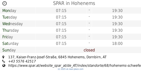
SPAR
Kaiser-Franz-Josef-Straße 137, Hohenems
Supermarket
read more
1.781 km
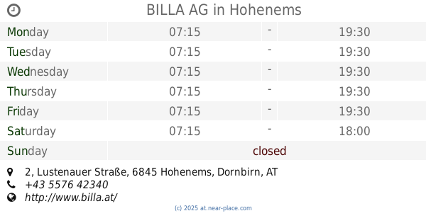
BILLA AG
Lustenauer Straße 2, Hohenems
Supermarket
read more
2.394 km
SPAR Daniel Schöpfer
Neue Landstraße 40, Mäder
Supermarket
read more
2.44 km
HOFER
Bundesstraße 6, Koblach
Supermarket
read more
2.44 km
HOFER Koblach
Bundesstraße 6, Koblach
Supermarket
read more
3.081 km
Gunz Shop
Im Hau 21, Mäder
Supermarket
read more
3.193 km
HOFER
Barnabas-Fink-Straße 1, Hohenems
Supermarket
read more
3.193 km
HOFER Hohenems
Barnabas-Fink-Straße 1, Hohenems
Supermarket
read more
3.452 km
EUROSPAR
Bahnhofstraße 10, Hohenems
Supermarket
read more
3.677 km
EUROSPAR
Lustenauer Straße 107a, Hohenems
Supermarket
read more
4.003 km
SPAR
Letten 2, Koblach
Supermarket
read more
4.003 km
SPAR Metzler Bernhard
Letten 2, Koblach
Supermarket
read more
4.066 km
Sutterlüty Ländlemarkt
Lustenauer Straße 125, Hohenems
Supermarket
read more
4.102 km
Adeg Neumann
Treietstraße 17, Klaus
Supermarket
read more
4.174 km
SPAR Georg Mangold KG
Treiet 7, Weiler
Supermarket
read more
4.419 km
Sutterlüty Ländlemarkt
Walgaustraße 7, Weiler
Supermarket
read more
4.949 km
Migros
Hintere Kirchstrasse 1, Diepoldsau
Supermarket
read more
📑
all categories
Accounting
Administrative area level 1
Administrative area level 2
Airport
Amusement park
Aquarium
Art gallery
Atm
Bakery
Bank
Bar
Beauty salon
Bicycle store
Book store
Bowling alley
Bus station
Cafe
Campground
Car dealer
Car rental
Car repair
Car wash
Casino
Cemetery
Church
City hall
Clothing store
Colloquial area
Convenience store
Country
Courthouse
Dentist
Department store
Doctor
Electrician
Electronics store
Embassy
Finance
Fire station
Florist
Food
Funeral home
Furniture store
Gas station
General contractor
Grocery or supermarket
Gym
Hair care
Hardware store
Health
Hindu Temple
Home goods store
Hospital
Insurance agency
Jewelry store
Laundry
Lawyer
Library
Light rail station
Liquor store
Local government office
Locality
Locksmith
Lodging
Meal delivery
Meal takeaway
Mosque
Movie rental
Movie theater
Moving company
Museum
Natural feature
Neighborhood
Night club
Painter
Park
Parking
Pet store
Pharmacy
Physiotherapist
Place of worship
Plumber
Point of interest
Police
Political
Post office
Premise
Real estate agency
Restaurant
Roofing contractor
Route
Rv park, camping
School
Shoe store
Shopping mall
Spa
Stadium
Storage
Store
Subpremise
Subway station
Supermarket
Synagogue
Taxi stand
Train station
Transit station
Travel agency
University
Veterinary care
Zoo
administrative area level 3
sublocality level 1
↑