Supermarket nearby Lidl
Austria
Supermarket nearby Lidl
Lidl
117, Oberfeldstraße, 4600, Wels, Wels, AT Østrig
contacts phone
:
+43 800 500810
website:
www.lidl.at
Latitude:
48.1832514
, Longitude:
14.0179723
larger map & directions
read more
nearest Supermarket
Lidl Österreich GmbH
Oberfeldstraße 117, Wels
Supermarket
read more
301 m
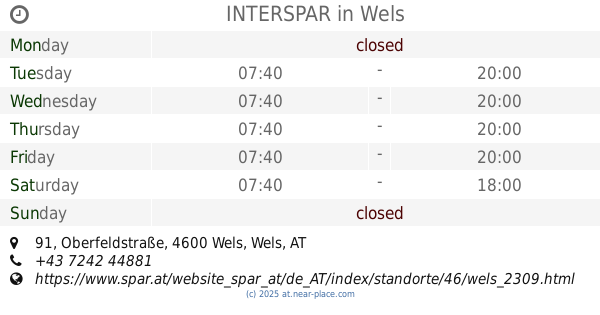
INTERSPAR
Oberfeldstraße 91, Wels
Supermarket
read more
359 m
BILLA AG
Grieskirchner Straße 121, Wels
Supermarket
read more
589 m
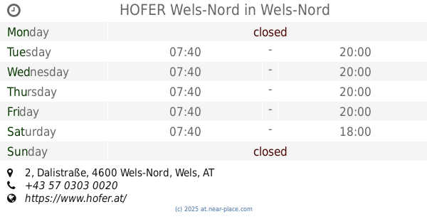
HOFER Wels-Nord
Dalistraße 2, Wels-Nord
Supermarket
read more
589 m
HOFER
Dalistraße 2, Wels-Nord
Supermarket
read more
697 m
Merkur Markt
Mitterfeldstraße 2, Wels
Supermarket
read more
1.305 km
NORMA Filiale
Oberfeldstraße 58, Wels
Supermarket
read more
1.526 km
UNIMARKT Partner SMARTWORK GMBH
Grieskirchner Straße 17, Wels
Supermarket
read more
1.526 km
Unimarkt
Grieskirchner Straße 17, Wels
Supermarket
read more
1.621 km
Spar
Grieskirchner Straße 9, Wels
Supermarket
read more
1.726 km
BILLA AG
Eferdinger Straße 16, Wels
Supermarket
read more
1.985 km
HOFER
Römerstraße 142, Wels
Supermarket
read more
1.985 km
HOFER Wels
Römerstraße 142, Wels
Supermarket
read more
2.044 km
PENNY Markt
Eiselbergstraße 4, Wels
Supermarket
read more
2.313 km
SPAR
Römerstraße 148, Wels
Supermarket
read more
2.362 km
Lidl
Magazinstraße 8-10, Wels
Supermarket
read more
2.435 km
SPAR
Vogelweiderstraße 9, Wels
Supermarket
read more
2.435 km
SPAR Perspektive Handel Caritas gGmbH
Vogelweiderstraße 9, Wels
Supermarket
read more
2.624 km
HOFER Wels
Linzer Straße 99, Wels
Supermarket
read more
2.624 km
HOFER
Linzer Straße 99, Wels
Supermarket
read more
2.661 km
NORMA Filiale
Salzburger Straße 27, Wels
Supermarket
read more
2.715 km
DHL-Abholung Packet Dienst.
Billrothstraße 58, Wels
Supermarket
read more
2.959 km
Reformstark Martin
Stadtplatz 15, Wels
Supermarket
read more
3.186 km
HOFER
Wimpassinger Straße 1, Wels
Supermarket
read more
3.259 km
SPAR
Negrellistraße 27, Wels
Supermarket
read more
📑
all categories
Accounting
Administrative area level 1
Administrative area level 2
Airport
Amusement park
Aquarium
Art gallery
Atm
Bakery
Bank
Bar
Beauty salon
Bicycle store
Book store
Bowling alley
Bus station
Cafe
Campground
Car dealer
Car rental
Car repair
Car wash
Casino
Cemetery
Church
City hall
Clothing store
Colloquial area
Convenience store
Country
Courthouse
Dentist
Department store
Doctor
Electrician
Electronics store
Embassy
Finance
Fire station
Florist
Food
Funeral home
Furniture store
Gas station
General contractor
Grocery or supermarket
Gym
Hair care
Hardware store
Health
Hindu Temple
Home goods store
Hospital
Insurance agency
Jewelry store
Laundry
Lawyer
Library
Light rail station
Liquor store
Local government office
Locality
Locksmith
Lodging
Meal delivery
Meal takeaway
Mosque
Movie rental
Movie theater
Moving company
Museum
Natural feature
Neighborhood
Night club
Painter
Park
Parking
Pet store
Pharmacy
Physiotherapist
Place of worship
Plumber
Point of interest
Police
Political
Post office
Premise
Real estate agency
Restaurant
Roofing contractor
Route
Rv park, camping
School
Shoe store
Shopping mall
Spa
Stadium
Storage
Store
Subpremise
Subway station
Supermarket
Synagogue
Taxi stand
Train station
Transit station
Travel agency
University
Veterinary care
Zoo
administrative area level 3
sublocality level 1
↑