Supermarket nearby Penny Markt
Austria
Supermarket nearby Penny Markt
Penny Markt
Kreuzgasse 48-50, Wien Ausztria
contacts phone
:
+43
Latitude:
48.2242681
, Longitude:
16.3361397
read more
nearest Supermarket
143 m
BILLA AG
Kalvarienberggasse 67-69, Wien
Supermarket
read more
278 m
BILLA AG
Schumanngasse 88, Wien
Supermarket
read more
427 m
HOFER Wien 18., Währing
Martinstraße 57-61, Wien
Supermarket
read more
427 m
HOFER Wien 18., Währing
Martinst.57-61/Staudg.28-30, Wien 18., Währing
Supermarket
read more
439 m
BILLA AG
Martinstraße 53, Wien
Supermarket
read more
609 m
Aksam
Kalvarienberggasse 38, Wien
Supermarket
read more
659 m
HOFER Wien 17., Hernals
Bergsteiggasse 36-38, Wien
Supermarket
read more
659 m
HOFER
Bergsteiggasse 36-38, Wien
Supermarket
read more
683 m
BILLA AG
Elterleinplatz 12, Wien
Supermarket
read more
723 m
INTERSPAR
Jörgerstraße 24, Wien
Supermarket
read more
734 m
Dhl Shop
Hormayrgasse 3, Wien
Supermarket
read more
798 m
Shakhenabat Iranische supermarkt
Jörgerstraße 10, Wien
Supermarket
read more
815 m
BILLA AG
Hernalser Hauptstraße 86, Wien
Supermarket
read more
820 m
SPAR
Währinger Gürtel 18-20, AKH, Wien
Supermarket
read more
842 m
SPAR
Währinger Straße 90-92, Wien
Supermarket
read more
860 m
HOFER
Hernalser Hauptstraße 22, Wien 17., Hernals
Supermarket
read more
875 m
ETSAN Supermarkt
Währinger Straße 86, Wien
Supermarket
read more
898 m
SPAR Gourmet
Gymnasiumstraße 30, Wien
Supermarket
read more
898 m
SPAR
Gymnasiumstraße 30, Wien
Supermarket
read more
936 m
Lidl
Hernalser Hauptstraße 103, Wien
Supermarket
read more
1.057 km
Merkur Markt
Geblergasse 73-75, Wien
Supermarket
read more
1.097 km
Emma Otto
Anastasius-Grün-Gasse 13, Wien
Supermarket
read more
1.209 km
BILLA AG
Alser Straße 34, Wien
Supermarket
read more
1.273 km
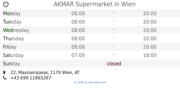
AKMAR Supermarket
Mayssengasse 22, Wien
Supermarket
read more
1.333 km
SPAR
Alser Straße 22, Wien
Supermarket
read more
📑
all categories
Accounting
Administrative area level 1
Administrative area level 2
Airport
Amusement park
Aquarium
Art gallery
Atm
Bakery
Bank
Bar
Beauty salon
Bicycle store
Book store
Bowling alley
Bus station
Cafe
Campground
Car dealer
Car rental
Car repair
Car wash
Casino
Cemetery
Church
City hall
Clothing store
Colloquial area
Convenience store
Country
Courthouse
Dentist
Department store
Doctor
Electrician
Electronics store
Embassy
Finance
Fire station
Florist
Food
Funeral home
Furniture store
Gas station
General contractor
Grocery or supermarket
Gym
Hair care
Hardware store
Health
Hindu Temple
Home goods store
Hospital
Insurance agency
Jewelry store
Laundry
Lawyer
Library
Light rail station
Liquor store
Local government office
Locality
Locksmith
Lodging
Meal delivery
Meal takeaway
Mosque
Movie rental
Movie theater
Moving company
Museum
Natural feature
Neighborhood
Night club
Painter
Park
Parking
Pet store
Pharmacy
Physiotherapist
Place of worship
Plumber
Point of interest
Police
Political
Post office
Premise
Real estate agency
Restaurant
Roofing contractor
Route
Rv park, camping
School
Shoe store
Shopping mall
Spa
Stadium
Storage
Store
Subpremise
Subway station
Supermarket
Synagogue
Taxi stand
Train station
Transit station
Travel agency
University
Veterinary care
Zoo
administrative area level 3
sublocality level 1
↑