Supermarket nearby PENNY Markt
Coronavirus disease (COVID-19) Situation
confirmed cases
6081287
deaths
22542
Austria
Supermarket nearby PENNY Markt
PENNY Markt
Leobner Straße 30, Niklasdorf Österreich
contacts phone
:
+43
Latitude:
47.3962156
, Longitude:
15.1613856
read more
nearest Supermarket
785 m
BILLA AG
Proleber Straße 2, Niklasdorf
Supermarket
read more
4.324 km
Lidl Österreich GmbH
Kärntner Straße 89, Leoben
Supermarket
read more
4.324 km
Lidl
Kärntner Straße 89, Leoben
Supermarket
read more
4.458 km
HOFER Leoben
Kärntner Straße 92, Leoben
Supermarket
read more
4.458 km
HOFER
Kärntner Straße 92, Leoben
Supermarket
read more
4.622 km
SPAR
Judendorfer Straße 64-66, Leoben
Supermarket
read more
4.908 km
BILLA AG
Draschestraße 5, Leoben
Supermarket
read more
5.157 km
SPAR
Hauptplatz 19, Leoben
Supermarket
read more
5.167 km
Reformstark Martin
Hauptplatz 19, Leoben City Shopping, Leoben
Supermarket
read more
5.798 km
INTERSPAR
Zeltenschlagstraße 2, Leoben
Supermarket
read more
6.002 km
Merkur Markt
Pichlmayergasse 16, Leoben-Leitendorf
Supermarket
read more
6.212 km
ADEG Schuss
Steigtalstraße 26, Leoben
Supermarket
read more
6.212 km
ADEG Leoben
Steigtalstraße 26, Leoben
Supermarket
read more
6.319 km
BILLA AG
Turmgasse 21, Leoben
Supermarket
read more
6.982 km
BILLA AG
Pestalozzistraße 71, Leoben
Supermarket
read more
8.318 km
Lidl
Leobner Straße 19, Bruck an der Mur
Supermarket
read more
8.854 km
PENNY Markt
Grazer Straße 81, Kapfenberg
Supermarket
read more
10.581 km
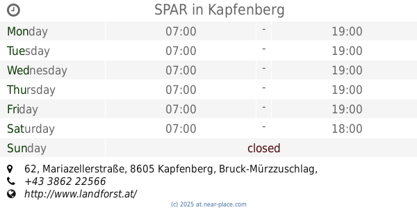
SPAR
Mariazellerstraße 62, Kapfenberg
Supermarket
read more
11.466 km
EUROSPAR
Wiener Straße 49, Kapfenberg
Supermarket
read more
12.623 km
BILLA AG
BUNDESSTRASSE 53 A
Supermarket
read more
12.959 km
HOFER
Kärntner Straße 4, Sankt Michael in der Obersteiermark
Supermarket
read more
14.682 km
BILLA AG
Hugo-Wolf-Straße 3
Supermarket
read more
15.381 km
SPAR
Igo-Etrich-Straße 2
Supermarket
read more
15.381 km
SPAR Wolfgang Bauer e.U.
Igo-Etrich-Straße 2
Supermarket
read more
15.954 km
SPAR
Seestraße 1, Sankt Lorenzen im Mürztal
Supermarket
read more
📑
all categories
Accounting
Administrative area level 1
Administrative area level 2
Airport
Amusement park
Aquarium
Art gallery
Atm
Bakery
Bank
Bar
Beauty salon
Bicycle store
Book store
Bowling alley
Bus station
Cafe
Campground
Car dealer
Car rental
Car repair
Car wash
Casino
Cemetery
Church
City hall
Clothing store
Colloquial area
Convenience store
Country
Courthouse
Dentist
Department store
Doctor
Electrician
Electronics store
Embassy
Finance
Fire station
Florist
Food
Funeral home
Furniture store
Gas station
General contractor
Grocery or supermarket
Gym
Hair care
Hardware store
Health
Hindu Temple
Home goods store
Hospital
Insurance agency
Jewelry store
Laundry
Lawyer
Library
Light rail station
Liquor store
Local government office
Locality
Locksmith
Lodging
Meal delivery
Meal takeaway
Mosque
Movie rental
Movie theater
Moving company
Museum
Natural feature
Neighborhood
Night club
Painter
Park
Parking
Pet store
Pharmacy
Physiotherapist
Place of worship
Plumber
Point of interest
Police
Political
Post office
Premise
Real estate agency
Restaurant
Roofing contractor
Route
Rv park, camping
School
Shoe store
Shopping mall
Spa
Stadium
Storage
Store
Subpremise
Subway station
Supermarket
Synagogue
Taxi stand
Train station
Transit station
Travel agency
University
Veterinary care
Zoo
administrative area level 3
sublocality level 1
↑