Bar nearby Peter Thurnbichler
Austria
Bar nearby Peter Thurnbichler
Peter Thurnbichler
Heiligwasserweg 47, Kurort Igls Austria
contacts phone
:
+43
Latitude:
47.2171063
, Longitude:
11.4309043
read more
nearest Bar
222 m
Teehütte
Heiligwasserweg 39, Innsbruck
Bar
read more
4.838 km
Sportsbar Olympiahalle
Olympiastraße 10, Innsbruck
Bar
read more
4.938 km
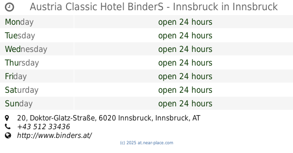
Austria Classic Hotel BinderS - Innsbruck
Doktor-Glatz-Straße 20, Innsbruck
Bar
read more
4.949 km
Abyss Bar
Amraser-See-Straße 5, Innsbruck
Bar
read more
4.96 km
Rote Laterne
Neurauthgasse 5, Innsbruck
Bar
read more
4.99 km
KosuLongue
Doktor-Glatz-Straße 18, Innsbruck
Bar
read more
5.125 km
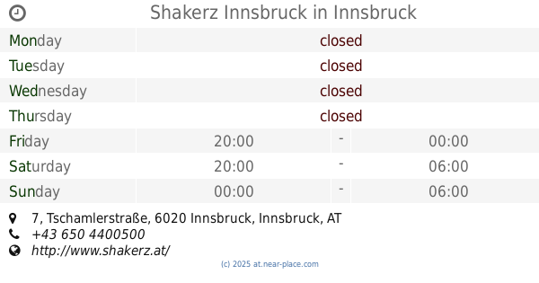
Shakerz Innsbruck
Tschamlerstraße 7, Innsbruck
Bar
read more
5.175 km
Nargile Cafe (Mor Işıklı Masa)
Leopoldstraße 42a, Innsbruck
Bar
read more
5.31 km
Nachtschwärmer
Innsbrucker Straße 22-24, Innsbruck
Bar
read more
5.36 km
Cafe Platzl
Mentlgasse 4, Innsbruck
Bar
read more
5.389 km
ADMIRAL Filiale
Templstraße 32, Innsbruck
Bar
read more
5.499 km
G's Brothel
Egger-Lienz-Straße 48, Innsbruck
Bar
read more
5.538 km
Cojiba Bar
Adamgasse 5, Innsbruck
Bar
read more
5.66 km
Moksh cafe bar
Schöpfstrasse, Innsbruck
Bar
read more
5.668 km
moksh cafe bar
Schöpfstrasse 6b, Innsbruck
Bar
read more
5.674 km
Cafe Gallery Ararat
Schöpfstraße 6b, Innsbruck
Bar
read more
5.724 km
Cafe Jolly
Müllerstraße 21, Innsbruck
Bar
read more
5.966 km
Bar/Cafe Karwendelbogen 33
Karwendelbögen 33, Innsbruck
Bar
read more
5.966 km
Cafe GALAXY
Karwendelbögen 33-35, Innsbruck
Bar
read more
6.006 km
Monroes Bar
Innrain 87, Innsbruck
Bar
read more
6.157 km
Limerick Bill's Irish Pub
Maria-Theresien-Straße 9, Innsbruck
Bar
read more
6.319 km
Huber Yellowstone KEG
Ingenieur-Etzel-Straße 50, Innsbruck
Bar
read more
6.411 km
Culinarium in the old town
Pfarrgasse 1, Innsbruck
Bar
read more
6.613 km
Runner Runner Innsbruck, Austria
Angergasse, Innsbruck
Bar
read more
15.598 km
Schwarze Katz
Dorfplatz 2, Zirl
Bar
read more
📑
all categories
Accounting
Administrative area level 1
Administrative area level 2
Airport
Amusement park
Aquarium
Art gallery
Atm
Bakery
Bank
Bar
Beauty salon
Bicycle store
Book store
Bowling alley
Bus station
Cafe
Campground
Car dealer
Car rental
Car repair
Car wash
Casino
Cemetery
Church
City hall
Clothing store
Colloquial area
Convenience store
Country
Courthouse
Dentist
Department store
Doctor
Electrician
Electronics store
Embassy
Finance
Fire station
Florist
Food
Funeral home
Furniture store
Gas station
General contractor
Grocery or supermarket
Gym
Hair care
Hardware store
Health
Hindu Temple
Home goods store
Hospital
Insurance agency
Jewelry store
Laundry
Lawyer
Library
Light rail station
Liquor store
Local government office
Locality
Locksmith
Lodging
Meal delivery
Meal takeaway
Mosque
Movie rental
Movie theater
Moving company
Museum
Natural feature
Neighborhood
Night club
Painter
Park
Parking
Pet store
Pharmacy
Physiotherapist
Place of worship
Plumber
Point of interest
Police
Political
Post office
Premise
Real estate agency
Restaurant
Roofing contractor
Route
Rv park, camping
School
Shoe store
Shopping mall
Spa
Stadium
Storage
Store
Subpremise
Subway station
Supermarket
Synagogue
Taxi stand
Train station
Transit station
Travel agency
University
Veterinary care
Zoo
administrative area level 3
sublocality level 1
↑