Cafe nearby Wendlstube
Coronavirus disease (COVID-19) Situation
confirmed cases
6081287
deaths
22542
Austria
Cafe nearby Wendlstube
Wendlstube
1, Gumppstraße, 6020, Innsbruck, Innsbruck, AT Austria
contacts phone
:
+43 664 5124169
Latitude:
47.2638549
, Longitude:
11.4084533
larger map & directions
read more
nearest Cafe
124 m
Cafe Bianka
Pradler Straße 78, Innsbruck
Cafe
read more
179 m
Le Cafe
Pradler Straße 38, Innsbruck
Cafe
read more
229 m
Cafe Tyrol
Roseggerstraße 2, Innsbruck
Cafe
read more
262 m
Alpin Park Hotel
Pradler Straße 28, Innsbruck
Cafe
read more
397 m
Cafe Platzl
Amraser Straße 1, Innsbruck
Cafe
read more
405 m
Cafe Enoteca Tipico
Museumstraße 38, Innsbruck
Cafe
read more
496 m
Cafe Design
Anton-Eder-Straße 21, Innsbruck
Cafe
read more
602 m
Testa Rossa
Hauptbahnhof Unterführung, Innsbruck
Cafe
read more
748 m
Cafe Atrium
Meinhardstraße 3, Innsbruck
Cafe
read more
780 m
Cafe Okay
Adamgasse 13, Innsbruck
Cafe
read more
806 m
Cafe City, Gebrüder Murauer GmbH
Meinhardstraße 16, Innsbruck
Cafe
read more
823 m
Papillon Cafe
Mentlgasse 18a, Innsbruck
Cafe
read more
830 m
Cafe-Bar Plateau
Ingenieur-Etzel-Straße 51, Innsbruck
Cafe
read more
865 m
Cafe Bambi
Schwindstraße 1, Innsbruck
Cafe
read more
960 m
Café Central
Gilmstraße 5, Innsbruck
Cafe
read more
972 m
Cafe Tagblatt
Salurner Straße 15, Innsbruck
Cafe
read more
982 m
Le Petit - Das kleine Bistro
Leopoldstraße 21a, Innsbruck
Cafe
read more
990 m
Crema Coffee and Delights
Maria-Theresien-Straße 49, Innsbruck
Cafe
read more
994 m
Immerland
Leopoldstraße 27, Innsbruck
Cafe
read more
999 m
Remix Bögen
Viaduktbogen 3, Innsbruck
Cafe
read more
1.042 km
Cafe-Pub Black-Horse
Andechsstraße 44, Innsbruck
Cafe
read more
1.051 km
Segafredo Espresso
24, Leopoldstraße, Innsbruck
Cafe
read more
1.119 km
Cafe-Konditorei Törtchen
Leopoldstraße 47, Innsbruck
Cafe
read more
1.332 km
Reichenauerstüberl
Wörndlestraße 19, Innsbruck
Cafe
read more
1.358 km
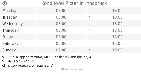
Konditorei Ritzer
Klappholzstraße 35a, Innsbruck
Cafe
read more
📑
all categories
Accounting
Administrative area level 1
Administrative area level 2
Airport
Amusement park
Aquarium
Art gallery
Atm
Bakery
Bank
Bar
Beauty salon
Bicycle store
Book store
Bowling alley
Bus station
Cafe
Campground
Car dealer
Car rental
Car repair
Car wash
Casino
Cemetery
Church
City hall
Clothing store
Colloquial area
Convenience store
Country
Courthouse
Dentist
Department store
Doctor
Electrician
Electronics store
Embassy
Finance
Fire station
Florist
Food
Funeral home
Furniture store
Gas station
General contractor
Grocery or supermarket
Gym
Hair care
Hardware store
Health
Hindu Temple
Home goods store
Hospital
Insurance agency
Jewelry store
Laundry
Lawyer
Library
Light rail station
Liquor store
Local government office
Locality
Locksmith
Lodging
Meal delivery
Meal takeaway
Mosque
Movie rental
Movie theater
Moving company
Museum
Natural feature
Neighborhood
Night club
Painter
Park
Parking
Pet store
Pharmacy
Physiotherapist
Place of worship
Plumber
Point of interest
Police
Political
Post office
Premise
Real estate agency
Restaurant
Roofing contractor
Route
Rv park, camping
School
Shoe store
Shopping mall
Spa
Stadium
Storage
Store
Subpremise
Subway station
Supermarket
Synagogue
Taxi stand
Train station
Transit station
Travel agency
University
Veterinary care
Zoo
administrative area level 3
sublocality level 1
↑