Bakery nearby Auer Brot
Austria
Bakery nearby Auer Brot
Auer Brot
Stiftingtalstraße 3, Graz Österreich
contacts phone
:
+43
Latitude:
47.0795665
, Longitude:
15.4673552
read more
nearest Bakery
844 m
Sorger
Leonhardstraße 89, Graz
Bakery
read more
1.31 km
Törtchenprinzessin
Schillerstraße 49, Graz
Bakery
read more
1.382 km
Hubert Auer
Zinzendorfgasse 32, Graz
Bakery
read more
1.4 km
Konditorei Philipp
Krenngasse 38, Graz
Bakery
read more
1.49 km
Auer Hubert BetriebsgesmbH
Leonhardstraße 20, Graz
Bakery
read more
1.638 km
Kern Julius GesmbH
Rechbauerstraße 23, Graz
Bakery
read more
1.647 km
Bäckerei Kern
Rechbauerstraße 23, Graz
Bakery
read more
1.697 km
Kern Julius GesmbH
Mariatroster Straße 93, Graz-Kroisbach
Bakery
read more
1.807 km
Hubert Auer Marktstand
Geidorfplatz 2, Graz
Bakery
read more
1.919 km
Auer Brot
Kaiser-Josef-Platz 4, Graz
Bakery
read more
1.926 km
Conditorei Leinich
Kaiser-Josef-Platz 4, Graz
Bakery
read more
1.951 km
Mr. Heinz Regula
Brockmanngasse 8, Graz
Bakery
read more
2.133 km
Zafita
Girardigasse 6-8, Graz
Bakery
read more
2.149 km
Auer Brot
Dietrichsteinplatz 13, Graz
Bakery
read more
2.203 km
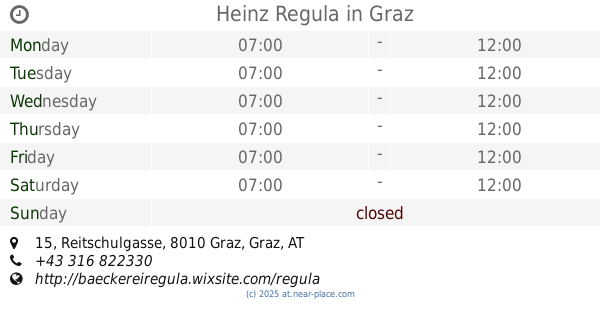
Heinz Regula
Reitschulgasse 15, Graz
Bakery
read more
2.227 km
Kern Julius GesmbH
Jakominiplatz 10, Graz
Bakery
read more
2.231 km
Bäckerei Kern
Jakominiplatz 10, Graz
Bakery
read more
2.278 km
Martin Auer Bread Kitchen
Jakominiplatz 1, Graz
Bakery
read more
2.278 km
Backwerk
Jakominiplatz 14S, Graz
Bakery
read more
2.278 km
Martin Auer Brotküche
Jakominiplatz 1, Graz
Bakery
read more
2.296 km
Hubert Auer - Jakominiplatz
Jakominiplatz, Graz
Bakery
read more
2.312 km
Auer Brot
Jakominiplatz 1, Graz
Bakery
read more
2.321 km
Tasty Donuts & Coffee
Jakominiplatz 16, Graz
Bakery
read more
2.412 km
Bäckerei Sorger
Jakominiplatz 21, Graz
Bakery
read more
2.485 km
Das Tortenatelier Genusscafé
Jakoministraße 31, Graz
Bakery
read more
📑
all categories
Accounting
Administrative area level 1
Administrative area level 2
Airport
Amusement park
Aquarium
Art gallery
Atm
Bakery
Bank
Bar
Beauty salon
Bicycle store
Book store
Bowling alley
Bus station
Cafe
Campground
Car dealer
Car rental
Car repair
Car wash
Casino
Cemetery
Church
City hall
Clothing store
Colloquial area
Convenience store
Country
Courthouse
Dentist
Department store
Doctor
Electrician
Electronics store
Embassy
Finance
Fire station
Florist
Food
Funeral home
Furniture store
Gas station
General contractor
Grocery or supermarket
Gym
Hair care
Hardware store
Health
Hindu Temple
Home goods store
Hospital
Insurance agency
Jewelry store
Laundry
Lawyer
Library
Light rail station
Liquor store
Local government office
Locality
Locksmith
Lodging
Meal delivery
Meal takeaway
Mosque
Movie rental
Movie theater
Moving company
Museum
Natural feature
Neighborhood
Night club
Painter
Park
Parking
Pet store
Pharmacy
Physiotherapist
Place of worship
Plumber
Point of interest
Police
Political
Post office
Premise
Real estate agency
Restaurant
Roofing contractor
Route
Rv park, camping
School
Shoe store
Shopping mall
Spa
Stadium
Storage
Store
Subpremise
Subway station
Supermarket
Synagogue
Taxi stand
Train station
Transit station
Travel agency
University
Veterinary care
Zoo
administrative area level 3
sublocality level 1
↑