Bakery nearby Gerhard Hornung
Austria
Bakery nearby Gerhard Hornung
Gerhard Hornung
Lendplatz 28, Graz Østrig
contacts phone
:
+43
Latitude:
47.0769163
, Longitude:
15.4291321
read more
nearest Bakery
160 m
Viktor König
Lendplatz, Marktstand 119, Graz
Bakery
read more
435 m
Schlossbergbäckerei Schudi
Wickenburggasse 15, Graz
Bakery
read more
630 m
Viktor König
Theodor-Körner-Straße 37, Graz
Bakery
read more
638 m
PANE- Martin Auer
Mariahilferstraße 11, Graz
Bakery
read more
666 m
Backwerk
Annenstraße 23, Graz
Bakery
read more
671 m
Auer Brot
Körösistraße 64, Graz
Bakery
read more
699 m
Sorger
Südtiroler Platz 14, Graz
Bakery
read more
756 m
Bäckerei und Backhaus Agramer Art
Hackhergasse 2, Graz
Bakery
read more
764 m
Annenbäckerei
Annenstraße 54, Graz
Bakery
read more
828 m
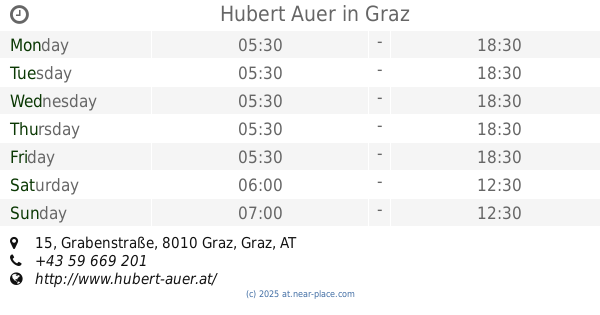
Hubert Auer
Grabenstraße 15, Graz
Bakery
read more
835 m
Bäckerei Strohmayer
Sackstraße 8, Graz
Bakery
read more
868 m
Bäckerei Sorger
Franziskanerplatz 14, Graz
Bakery
read more
905 m
Sorger
Sporgasse 4, Graz
Bakery
read more
906 m
Auer Martin Brot GmbH
Bahnhofgürtel 89, Graz
Bakery
read more
912 m
Sorger
Bahnhofgürtel 89, Graz
Bakery
read more
919 m
Martin Auer - Hauptplatz
Hauptplatz 12, Graz
Bakery
read more
945 m
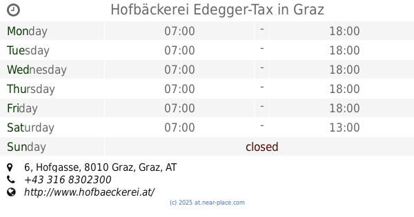
Hofbäckerei Edegger-Tax
Hofgasse 6, Graz
Bakery
read more
969 m
Hubert Auer - Hauptplatz
Hauptplatz 3, Graz
Bakery
read more
1.02 km
Auer Brot
Europaplatz 5, Graz
Bakery
read more
1.148 km
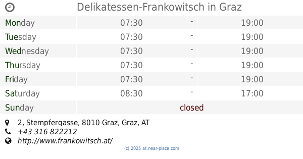
Delikatessen-Frankowitsch
Stempfergasse 2, Graz
Bakery
read more
1.239 km
Auer Brot
Stubenberggasse 10, Graz
Bakery
read more
1.476 km
Martin Auer Brotküche
Jakominiplatz 1, Graz
Bakery
read more
1.792 km
Auer Brot
Dietrichsteinplatz 13, Graz
Bakery
read more
1.868 km
Backhaus Hubert Auer
Lazarettgürtel 55, Graz
Bakery
read more
2.053 km
Auer Brot
Eggenberger Allee 30, Graz
Bakery
read more
📑
all categories
Accounting
Administrative area level 1
Administrative area level 2
Airport
Amusement park
Aquarium
Art gallery
Atm
Bakery
Bank
Bar
Beauty salon
Bicycle store
Book store
Bowling alley
Bus station
Cafe
Campground
Car dealer
Car rental
Car repair
Car wash
Casino
Cemetery
Church
City hall
Clothing store
Colloquial area
Convenience store
Country
Courthouse
Dentist
Department store
Doctor
Electrician
Electronics store
Embassy
Finance
Fire station
Florist
Food
Funeral home
Furniture store
Gas station
General contractor
Grocery or supermarket
Gym
Hair care
Hardware store
Health
Hindu Temple
Home goods store
Hospital
Insurance agency
Jewelry store
Laundry
Lawyer
Library
Light rail station
Liquor store
Local government office
Locality
Locksmith
Lodging
Meal delivery
Meal takeaway
Mosque
Movie rental
Movie theater
Moving company
Museum
Natural feature
Neighborhood
Night club
Painter
Park
Parking
Pet store
Pharmacy
Physiotherapist
Place of worship
Plumber
Point of interest
Police
Political
Post office
Premise
Real estate agency
Restaurant
Roofing contractor
Route
Rv park, camping
School
Shoe store
Shopping mall
Spa
Stadium
Storage
Store
Subpremise
Subway station
Supermarket
Synagogue
Taxi stand
Train station
Transit station
Travel agency
University
Veterinary care
Zoo
administrative area level 3
sublocality level 1
↑