Bakery nearby Gerhard Hornung
Austria
Bakery nearby Gerhard Hornung
Gerhard Hornung
25a, Vinzenzgasse, 8020, Graz, Graz, AT Austria
contacts phone
:
+43 316 570151
Latitude:
47.0732401
, Longitude:
15.4044985
larger map & directions
read more
nearest Bakery
175 m
Windisch & Biebl Bäckerei KG
Rochelgasse 9, Graz
Bakery
read more
251 m
Bäckerei Europa
Alte Poststraße 116, Graz
Bakery
read more
287 m
Sorger
Eggenberger Allee 36, Graz
Bakery
read more
302 m
Auer Brot
Eggenberger Allee 30, Graz
Bakery
read more
379 m
Konditorei Klescher
Alte Poststraße 90, Graz
Bakery
read more
888 m
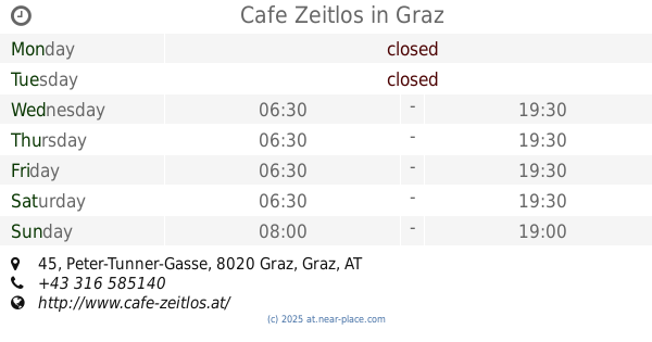
Cafe Zeitlos
Peter-Tunner-Gasse 45, Graz
Bakery
read more
892 m
Oni's Bäckerei
Karl-Morre-Straße 67, Graz
Bakery
read more
955 m
Auer Brot
Europaplatz 5, Graz
Bakery
read more
1.142 km
Auer Martin Brot GmbH
Bahnhofgürtel 89, Graz
Bakery
read more
1.415 km
Annenbäckerei
Annenstraße 54, Graz
Bakery
read more
1.611 km
Bäckerei und Backhaus Agramer Art
Hackhergasse 2, Graz
Bakery
read more
1.652 km
Kara Bäckerei KEG
Idlhofgasse 67, Graz
Bakery
read more
1.652 km
Kara Bakery KEG
Idlhofgasse 67, Graz
Bakery
read more
1.718 km
Better Sweet
Wiener Straße 164a, Graz
Bakery
read more
1.735 km
Better Sweet
Lend, Graz
Bakery
read more
1.802 km
Backwerk
Annenstraße 23, Graz
Bakery
read more
1.809 km
Agramer Bäckerei
Graz
Bakery
read more
1.831 km
Pekara Bäckerei
Lazarettgasse 34, Graz
Bakery
read more
1.834 km
Pizza - Burek
Lazarettgasse 34, Graz
Bakery
read more
1.909 km
Gerhard Hornung
Lendplatz 28, Graz
Bakery
read more
1.967 km
Viktor König
Lendplatz, Marktstand 119, Graz
Bakery
read more
2.255 km
Kern
Lazarettgürtel 55, Graz
Bakery
read more
2.276 km
Martin Auer
Lazarettgürtel 55, Graz
Bakery
read more
2.313 km
Backhaus Hubert Auer
Lazarettgürtel 55, Graz
Bakery
read more
2.524 km
Strohmayer
Karlauplatz 10, Graz
Bakery
read more
📑
all categories
Accounting
Administrative area level 1
Administrative area level 2
Airport
Amusement park
Aquarium
Art gallery
Atm
Bakery
Bank
Bar
Beauty salon
Bicycle store
Book store
Bowling alley
Bus station
Cafe
Campground
Car dealer
Car rental
Car repair
Car wash
Casino
Cemetery
Church
City hall
Clothing store
Colloquial area
Convenience store
Country
Courthouse
Dentist
Department store
Doctor
Electrician
Electronics store
Embassy
Finance
Fire station
Florist
Food
Funeral home
Furniture store
Gas station
General contractor
Grocery or supermarket
Gym
Hair care
Hardware store
Health
Hindu Temple
Home goods store
Hospital
Insurance agency
Jewelry store
Laundry
Lawyer
Library
Light rail station
Liquor store
Local government office
Locality
Locksmith
Lodging
Meal delivery
Meal takeaway
Mosque
Movie rental
Movie theater
Moving company
Museum
Natural feature
Neighborhood
Night club
Painter
Park
Parking
Pet store
Pharmacy
Physiotherapist
Place of worship
Plumber
Point of interest
Police
Political
Post office
Premise
Real estate agency
Restaurant
Roofing contractor
Route
Rv park, camping
School
Shoe store
Shopping mall
Spa
Stadium
Storage
Store
Subpremise
Subway station
Supermarket
Synagogue
Taxi stand
Train station
Transit station
Travel agency
University
Veterinary care
Zoo
administrative area level 3
sublocality level 1
↑