Bar nearby Forum für Kunst und Kultur Kammgarn
Austria
Bar nearby Forum für Kunst und Kultur Kammgarn
Forum für Kunst und Kultur Kammgarn
10, Spinnereistraße, 6971, Hard, Bregenz, AT Østrig
contacts phone
:
+43 5574 82731
website:
www.kammgarn.at
Latitude:
47.4974311
, Longitude:
9.6932749
larger map & directions
read more
nearest Bar
385 m
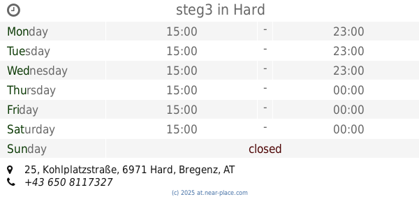
steg3
Kohlplatzstraße 25, Hard
Bar
read more
1.579 km
Tanzbar Nachtigall
Rheinstraße 74, Bregenz
Bar
read more
1.702 km
No. One-bar GmbH
Rheinstraße 83, Bregenz
Bar
read more
2.093 km
Le Billard
Hofsteigstraße 179, Hard
Bar
read more
2.396 km
Irish Pub
Michael-Gaismayr-Straße 29, Bregenz
Bar
read more
2.519 km
Chris/Kross
Mehrerauerstraße 52, Bregenz
Bar
read more
2.545 km
Wien-Salzburg-Berlin
Hinterfeldgasse, Bregenz
Bar
read more
2.742 km
Low Life
Mariahilfstraße 29, Bregenz
Bar
read more
2.881 km
Ambiente Bar Pub Billard
Mariahilfstraße 6, Bregenz
Bar
read more
3.084 km
Almchic
Lustenauer Straße 27, Hard
Bar
read more
3.103 km
Nightclubs Vorarlberg
Quellenstraße 30, Bregenz
Bar
read more
3.41 km
Gasthof Anker
Dorfstraße 52, Fußach
Bar
read more
3.62 km
Beachbar Bregenz
Seepromenade 2, Bregenz
Bar
read more
3.758 km
Erich Anton Drobez
Bundesstraße 73, Lauterach
Bar
read more
3.848 km
Fischersteg - Sunset Bar - Bregenz
Seeanlagen, Bregenz
Bar
read more
3.848 km
Fischersteeg – Sunset Bar Seeanlagen
Seestraße 1, Bregenz
Bar
read more
4.074 km
Prosecco Espresso Bar
Rathausstraße 1, Bregenz
Bar
read more
4.124 km
Kronenbar
Leutbühel 3a, Bregenz
Bar
read more
4.165 km
Kub-cafe
Karl-Tizian-Platz 1, Bregenz
Bar
read more
4.229 km
WSB-Bude
Brandgasse 1a, Bregenz
Bar
read more
4.255 km
Viva Cantina Mexicana Bar
Seestraße 7, Bregenz
Bar
read more
4.296 km
Paschanga 2.0
Kornmarktstraße 24, Bregenz
Bar
read more
4.567 km
Cafe-Bar Plauderer
Bundesstraße 63, Höchst
Bar
read more
5.178 km
Filou
Kellhofstraße 7, Wolfurt
Bar
read more
5.23 km
Lorenzo B
Kellhofstraße 3, Wolfurt
Bar
read more
📑
all categories
Accounting
Administrative area level 1
Administrative area level 2
Airport
Amusement park
Aquarium
Art gallery
Atm
Bakery
Bank
Bar
Beauty salon
Bicycle store
Book store
Bowling alley
Bus station
Cafe
Campground
Car dealer
Car rental
Car repair
Car wash
Casino
Cemetery
Church
City hall
Clothing store
Colloquial area
Convenience store
Country
Courthouse
Dentist
Department store
Doctor
Electrician
Electronics store
Embassy
Finance
Fire station
Florist
Food
Funeral home
Furniture store
Gas station
General contractor
Grocery or supermarket
Gym
Hair care
Hardware store
Health
Hindu Temple
Home goods store
Hospital
Insurance agency
Jewelry store
Laundry
Lawyer
Library
Light rail station
Liquor store
Local government office
Locality
Locksmith
Lodging
Meal delivery
Meal takeaway
Mosque
Movie rental
Movie theater
Moving company
Museum
Natural feature
Neighborhood
Night club
Painter
Park
Parking
Pet store
Pharmacy
Physiotherapist
Place of worship
Plumber
Point of interest
Police
Political
Post office
Premise
Real estate agency
Restaurant
Roofing contractor
Route
Rv park, camping
School
Shoe store
Shopping mall
Spa
Stadium
Storage
Store
Subpremise
Subway station
Supermarket
Synagogue
Taxi stand
Train station
Transit station
Travel agency
University
Veterinary care
Zoo
administrative area level 3
sublocality level 1
↑