Bar nearby Gasthof Anker
Austria
Bar nearby Gasthof Anker
Gasthof Anker
52, Dorfstraße, 6972, Fußach, Bregenz, AT Austria
contacts phone
:
+43 5578 730610
website:
www.gasthof-anker.at
Latitude:
47.47528
, Longitude:
9.66188
larger map & directions
read more
nearest Bar
790 m
Almchic
Lustenauer Straße 27, Hard
Bar
read more
1.309 km
Cafe-Bar Plauderer
Bundesstraße 63, Höchst
Bar
read more
3.068 km
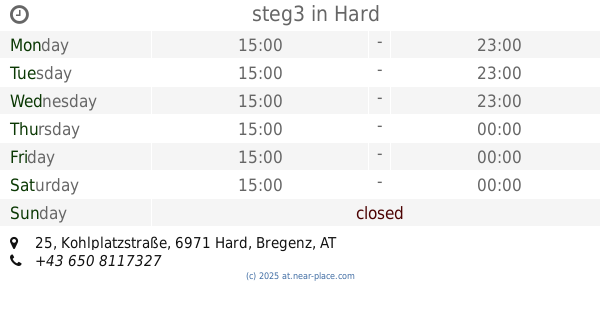
steg3
Kohlplatzstraße 25, Hard
Bar
read more
3.129 km
Online Bar
Johannes-Brasselstrasse 15, Sankt Margrethen
Bar
read more
3.146 km
Stadel
Bäumlestraße 75, Höchst
Bar
read more
3.41 km
Forum für Kunst und Kultur Kammgarn
Spinnereistraße 10, Hard
Bar
read more
4.085 km
Le Billard
Hofsteigstraße 179, Hard
Bar
read more
4.426 km
Culture Factor Y autonomer Jugend- u Kulturverein Lustenau
Amann-Fitz-Straße 6, Lustenau
Bar
read more
4.455 km
52 Magic Bar
Rheinstrasse 3, Au
Bar
read more
4.483 km
Tanzbar Nachtigall
Rheinstraße 74, Bregenz
Bar
read more
4.518 km
Brigitte Giovannini
Reichsstraße 46, Lustenau
Bar
read more
4.608 km
No. One-bar GmbH
Rheinstraße 83, Bregenz
Bar
read more
4.891 km
Fränkis
Widum 19, Lustenau
Bar
read more
4.899 km
Harlekin
Radetzkystr. 5, Lustenau
Bar
read more
5.074 km
White Horse Pub
Hauptstrasse 61, Au
Bar
read more
5.111 km
Irish Pub
Michael-Gaismayr-Straße 29, Bregenz
Bar
read more
5.236 km
Wien-Salzburg-Berlin
Hinterfeldgasse, Bregenz
Bar
read more
5.322 km
Riva Bar
Hauptstrasse 98, Au
Bar
read more
5.702 km
Chris/Kross
Mehrerauerstraße 52, Bregenz
Bar
read more
6.483 km
Saurerstoff Acetaia
Forachstraße 117, Dornbirn
Bar
read more
6.483 km
Obst-Guat zum Steirer
Forachstraße 117, Dornbirn
Bar
read more
8.314 km
S'Pub
Am Dorfplatz 4, Schwarzach
Bar
read more
9.999 km
Towerbar
Zanzenberggasse 2, Dornbirn
Bar
read more
13.302 km
Pumpwerk Hardcore Gym
Pumpwerk 9400, Industriestrasse 41A, Rorschach
Bar
read more
16.33 km
Arguna
Eisenbahnstraße 23, Langenargen
Bar
read more
📑
all categories
Accounting
Administrative area level 1
Administrative area level 2
Airport
Amusement park
Aquarium
Art gallery
Atm
Bakery
Bank
Bar
Beauty salon
Bicycle store
Book store
Bowling alley
Bus station
Cafe
Campground
Car dealer
Car rental
Car repair
Car wash
Casino
Cemetery
Church
City hall
Clothing store
Colloquial area
Convenience store
Country
Courthouse
Dentist
Department store
Doctor
Electrician
Electronics store
Embassy
Finance
Fire station
Florist
Food
Funeral home
Furniture store
Gas station
General contractor
Grocery or supermarket
Gym
Hair care
Hardware store
Health
Hindu Temple
Home goods store
Hospital
Insurance agency
Jewelry store
Laundry
Lawyer
Library
Light rail station
Liquor store
Local government office
Locality
Locksmith
Lodging
Meal delivery
Meal takeaway
Mosque
Movie rental
Movie theater
Moving company
Museum
Natural feature
Neighborhood
Night club
Painter
Park
Parking
Pet store
Pharmacy
Physiotherapist
Place of worship
Plumber
Point of interest
Police
Political
Post office
Premise
Real estate agency
Restaurant
Roofing contractor
Route
Rv park, camping
School
Shoe store
Shopping mall
Spa
Stadium
Storage
Store
Subpremise
Subway station
Supermarket
Synagogue
Taxi stand
Train station
Transit station
Travel agency
University
Veterinary care
Zoo
administrative area level 3
sublocality level 1
↑