Bar nearby Georg Köll
Austria
Bar nearby Georg Köll
Georg Köll
Tiroler Straße 121, Pettnau Austria
contacts phone
:
+43
Latitude:
47.2905738
, Longitude:
11.1644268
read more
nearest Bar
3.139 km
All Reith, Fam. Hanser
Römerstraße 22, Reith bei Seefeld
Bar
read more
3.526 km
Casa Marcioio
Buchweg 27, Inzing
Bar
read more
3.906 km
Strandcafe Sonja
Gschwandt
Bar
read more
4.554 km
Espresso Lounge
Bahnhofplatz 570, Seefeld in Tirol
Bar
read more
4.591 km
Parkcafe
Klosterstraße 1
Bar
read more
4.627 km
Omega Blue
Bahnhofstraße, Seefeld in Tirol
Bar
read more
4.633 km
Cafe Bar Coco
Bahnhofstraße 242, Seefeld in Tirol
Bar
read more
5.147 km
I-Tipft'l Cafe-Bar
Münchner Straße 142, Seefeld in Tirol
Bar
read more
5.271 km
Doubdle Austria GmbH
Leutascher Straße 810, Seefeld in Tirol
Bar
read more
6.129 km
Schwarze Katz
Dorfplatz 2, Zirl
Bar
read more
6.203 km
Rainer's Bar
Schulgasse 1, Zirl
Bar
read more
6.905 km
Gerry's Pub
Anton-Auer-Straße 9, Telfs
Bar
read more
6.95 km
Pasha 2312
Anton-Auer-Straße 11, Telfs
Bar
read more
6.996 km
ADMIRAL Filiale
Anton-Auer-Straße 19, Telfs
Bar
read more
9.541 km
Jugendraum Grinzens
Kirchgasse 9, Grinzens
Bar
read more
10.04 km
Pub Restaurant Partyservice Barometer
Kluibenschedlstraße 17, Rietz
Bar
read more
10.539 km
Hotel & Restaurant Kögele
Georg-Bucher-Straße 34, Axams
Bar
read more
12.121 km
Café Bar Rosso
Völs
Bar
read more
12.548 km
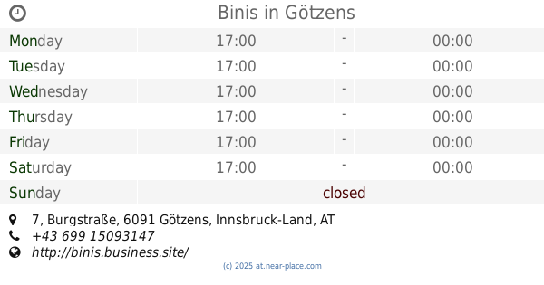
Bini's Bar
Burgstraße 7, Götzens
Bar
read more
12.549 km
Binis
Burgstraße 7, Götzens
Bar
read more
12.746 km
Verena’s Bar
Gießenweg 15, Völs
Bar
read more
12.8 km
Caro's Snack Bar and Breakfast
Gießenweg 15, Völs
Bar
read more
14.867 km
Hoadl Bar 2340
Axamer Lizum 7, Axamer Lizum
Bar
read more
15.085 km
Kupferpfandl
Kranebitter Allee 88, Innsbruck
Bar
read more
15.085 km
Club Diamond
Kranebitter Allee 88, Innsbruck
Bar
read more
📑
all categories
Accounting
Administrative area level 1
Administrative area level 2
Airport
Amusement park
Aquarium
Art gallery
Atm
Bakery
Bank
Bar
Beauty salon
Bicycle store
Book store
Bowling alley
Bus station
Cafe
Campground
Car dealer
Car rental
Car repair
Car wash
Casino
Cemetery
Church
City hall
Clothing store
Colloquial area
Convenience store
Country
Courthouse
Dentist
Department store
Doctor
Electrician
Electronics store
Embassy
Finance
Fire station
Florist
Food
Funeral home
Furniture store
Gas station
General contractor
Grocery or supermarket
Gym
Hair care
Hardware store
Health
Hindu Temple
Home goods store
Hospital
Insurance agency
Jewelry store
Laundry
Lawyer
Library
Light rail station
Liquor store
Local government office
Locality
Locksmith
Lodging
Meal delivery
Meal takeaway
Mosque
Movie rental
Movie theater
Moving company
Museum
Natural feature
Neighborhood
Night club
Painter
Park
Parking
Pet store
Pharmacy
Physiotherapist
Place of worship
Plumber
Point of interest
Police
Political
Post office
Premise
Real estate agency
Restaurant
Roofing contractor
Route
Rv park, camping
School
Shoe store
Shopping mall
Spa
Stadium
Storage
Store
Subpremise
Subway station
Supermarket
Synagogue
Taxi stand
Train station
Transit station
Travel agency
University
Veterinary care
Zoo
administrative area level 3
sublocality level 1
↑