Bar nearby Günter Eberl
Austria
Bar nearby Günter Eberl
Günter Eberl
Swarovskistraße 2, Wattens Austria
contacts phone
:
+43
Latitude:
47.2937511
, Longitude:
11.5931675
read more
nearest Bar
262 m
Cafe-Bar LP
Franz-Strickner-Straße 1, Wattens
Bar
read more
396 m
KIWI Wattens - Eis Café Pub Restaurant
Marienplatz 8 / EG, Wattens
Bar
read more
4.933 km
WEINPLATTFORM Handels KG
Brunnholzstraße 28, Mils
Bar
read more
6.556 km
Diana Bar
Oberer Stadtplatz, Hall in Tirol
Bar
read more
7.285 km
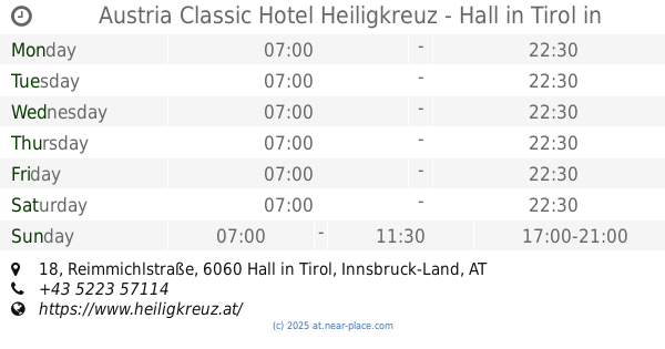
Austria Classic Hotel Heiligkreuz - Hall in Tirol
Reimmichlstraße 18, Hall in Tirol
Bar
read more
8.756 km
Prince Club
Loretto-Umgebung 2, Thaur
Bar
read more
10.016 km
FIFTY | FIFTY 50/50
An der Leiten 15, Vomp
Bar
read more
10.312 km
Cafe Parterre
Innsbrucker Straße 4, Schwaz
Bar
read more
13.621 km
Café Bar Mühlau
Hauptplatz 5, Innsbruck
Bar
read more
14.083 km
Jugendheim Pradl
Reichenauer Straße 15, Innsbruck
Bar
read more
14.187 km
Baguette
Pradler Straße 72, Innsbruck
Bar
read more
14.253 km
The Shakespeare Pub
Ingenieur-Etzel-Straße 80, Innsbruck
Bar
read more
14.586 km
Huber Yellowstone KEG
Ingenieur-Etzel-Straße 50, Innsbruck
Bar
read more
14.643 km
Club Cavall
Amraser Straße 6, Innsbruck
Bar
read more
14.659 km
Down Under
Ingenieur-Etzel-Straße 22, Innsbruck
Bar
read more
14.66 km
LUCKY Sport-Wetten
Amraser Straße 6, Innsbruck
Bar
read more
14.813 km
Ledio Nicntl
Brunecker Straße 3, Innsbruck
Bar
read more
14.851 km
Ayson Aksoy KEG
Museumstraße 34, Innsbruck
Bar
read more
14.918 km
Peter Thurnbichler
Heiligwasserweg 47, Kurort Igls
Bar
read more
15.101 km
mfg Bar
Adamgasse 13, Innsbruck
Bar
read more
15.232 km
Rote Laterne
Neurauthgasse 5, Innsbruck
Bar
read more
15.261 km
Cafe Platzl
Mentlgasse 4, Innsbruck
Bar
read more
15.374 km
Wettercafe
Leopoldstraße 2, Innsbruck
Bar
read more
15.41 km
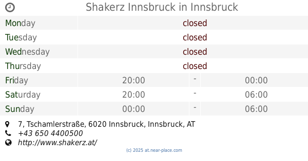
Shakerz Innsbruck
Tschamlerstraße 7, Innsbruck
Bar
read more
17.489 km
Nobody's Inn
Achenseestraße 58, Jenbach
Bar
read more
📑
all categories
Accounting
Administrative area level 1
Administrative area level 2
Airport
Amusement park
Aquarium
Art gallery
Atm
Bakery
Bank
Bar
Beauty salon
Bicycle store
Book store
Bowling alley
Bus station
Cafe
Campground
Car dealer
Car rental
Car repair
Car wash
Casino
Cemetery
Church
City hall
Clothing store
Colloquial area
Convenience store
Country
Courthouse
Dentist
Department store
Doctor
Electrician
Electronics store
Embassy
Finance
Fire station
Florist
Food
Funeral home
Furniture store
Gas station
General contractor
Grocery or supermarket
Gym
Hair care
Hardware store
Health
Hindu Temple
Home goods store
Hospital
Insurance agency
Jewelry store
Laundry
Lawyer
Library
Light rail station
Liquor store
Local government office
Locality
Locksmith
Lodging
Meal delivery
Meal takeaway
Mosque
Movie rental
Movie theater
Moving company
Museum
Natural feature
Neighborhood
Night club
Painter
Park
Parking
Pet store
Pharmacy
Physiotherapist
Place of worship
Plumber
Point of interest
Police
Political
Post office
Premise
Real estate agency
Restaurant
Roofing contractor
Route
Rv park, camping
School
Shoe store
Shopping mall
Spa
Stadium
Storage
Store
Subpremise
Subway station
Supermarket
Synagogue
Taxi stand
Train station
Transit station
Travel agency
University
Veterinary care
Zoo
administrative area level 3
sublocality level 1
↑