Bar nearby Harry's Music & Drinks
Austria
Bar nearby Harry's Music & Drinks
Harry's Music & Drinks
Salzburg Austria
contacts phone
:
+43
Latitude:
47.8080597
, Longitude:
13.065547
read more
nearest Bar
70 m
Boomerang Pub
Fürbergstraße 26, Salzburg
Bar
read more
504 m
Rockhouse Salzburg
46, Schallmooser Hauptstraße, Salzburg
Bar
read more
511 m
Rockhouse-Bar
Schallmooser Hauptstraße 46, Salzburg
Bar
read more
573 m
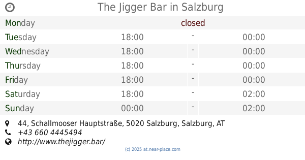
The Jigger Bar
Schallmooser Hauptstraße 44, Salzburg
Bar
read more
695 m
Bierheuriger Gastronomie
Gaisbergstraße 20, Salzburg
Bar
read more
884 m
Country Saloon
Schillinghofstraße 19, Salzburg-Gnigl
Bar
read more
921 m
Kastner´s Schenke
Schallmooser Hauptstraße 27, Salzburg
Bar
read more
994 m
Mexxx Gay Bar
Schallmooser Hauptstraße 20, Salzburg
Bar
read more
1.003 km
Daniela Rabensteiner
Kirchbergsteig 4, Salzburg
Bar
read more
1.225 km
Marshall Cafe Bar
Doktor-Franz-Rehrl-Platz 3, Salzburg
Bar
read more
1.346 km
Dark Eagle
Paracelsusstraße 11, Salzburg
Bar
read more
1.415 km
Marios
Linzer Gasse 54, Salzburg
Bar
read more
1.449 km
Coffee & Booze
Linzer Gasse 48, Salzburg
Bar
read more
1.54 km
Gillis OneRoomBar
Imbergstraße 11, Salzburg
Bar
read more
1.58 km
Beffa Bar
Bergstraße 13, Salzburg
Bar
read more
1.602 km
Havana - Die Bar bist Du
Priesterhausgasse 14, Salzburg
Bar
read more
1.612 km
Servus Tagesbar Christine Sappl
Bergstraße 18, Salzburg
Bar
read more
1.694 km
SEGABAR Rudolfskai
Rudolfskai 18, Salzburg
Bar
read more
1.722 km
Shamrock
Rudolfskai 12, Salzburg
Bar
read more
1.762 km
The Plaza
6, Rainerstraße, Salzburg
Bar
read more
1.77 km
Studio68
Bachstraße 68, Salzburg
Bar
read more
1.774 km
Crowne Plaza Salzburg - The Pitter
Rainerstraße 6-8, Salzburg
Bar
read more
1.81 km
Brothers Lounge - Shisha Bar
Elisabethstraße 6A, Salzburg
Bar
read more
1.939 km
2 Face Bar Cafe & Lounge
Jahnstraße 19, Salzburg
Bar
read more
2.054 km
Lackners Bar & Cafe
Badergäßchen 2, Salzburg
Bar
read more
📑
all categories
Accounting
Administrative area level 1
Administrative area level 2
Airport
Amusement park
Aquarium
Art gallery
Atm
Bakery
Bank
Bar
Beauty salon
Bicycle store
Book store
Bowling alley
Bus station
Cafe
Campground
Car dealer
Car rental
Car repair
Car wash
Casino
Cemetery
Church
City hall
Clothing store
Colloquial area
Convenience store
Country
Courthouse
Dentist
Department store
Doctor
Electrician
Electronics store
Embassy
Finance
Fire station
Florist
Food
Funeral home
Furniture store
Gas station
General contractor
Grocery or supermarket
Gym
Hair care
Hardware store
Health
Hindu Temple
Home goods store
Hospital
Insurance agency
Jewelry store
Laundry
Lawyer
Library
Light rail station
Liquor store
Local government office
Locality
Locksmith
Lodging
Meal delivery
Meal takeaway
Mosque
Movie rental
Movie theater
Moving company
Museum
Natural feature
Neighborhood
Night club
Painter
Park
Parking
Pet store
Pharmacy
Physiotherapist
Place of worship
Plumber
Point of interest
Police
Political
Post office
Premise
Real estate agency
Restaurant
Roofing contractor
Route
Rv park, camping
School
Shoe store
Shopping mall
Spa
Stadium
Storage
Store
Subpremise
Subway station
Supermarket
Synagogue
Taxi stand
Train station
Transit station
Travel agency
University
Veterinary care
Zoo
administrative area level 3
sublocality level 1
↑