Cafe nearby Seealm
Austria
Cafe nearby Seealm
Seealm
Pertisauer Landesstraße, Eben am Achensee Austria
contacts phone
:
+43
Latitude:
47.4262672
, Longitude:
11.7284084
read more
nearest Cafe
1.471 km
Café-Restaurant Klingler
Dorfstraße 41, Eben am Achensee
Cafe
read more
1.488 km
Hotel-Café-Restaurant Klingler
Dorfstraße 40/41, Eben am Achensee
Cafe
read more
1.936 km
moser´s Hotel
Dorfstraße 2
Cafe
read more
2.618 km
Vitalberg Cafe
3, Tiroler Steinöl Weg
Cafe
read more
2.633 km
Hotel Karwendel
Pertisau 54a-54b, Pertisau
Cafe
read more
2.863 km
Kaminstube Cafe- Rest beim Sportcenter
Pertisau 52, Eben am Achensee
Cafe
read more
3.036 km
Laterndl-Tanzcafe
Seebergstraße 15, Pertisau
Cafe
read more
3.06 km
Sandgruber GmbH
Pertisau 31a, Eben am Achensee
Cafe
read more
3.13 km
Cafe-Pension Erika
Haus 21a, Perstisau
Cafe
read more
4.81 km
Panoramic cafe
Kanzelkehre 510
Cafe
read more
5.084 km
Ossi's Pub
Postgasse 16, Jenbach
Cafe
read more
5.131 km
filos Weinbar & Cafe
Achenseestraße 34, Jenbach
Cafe
read more
5.723 km
Cafe Stressless
Dorf 33, Wiesing
Cafe
read more
5.951 km
Drive In
Austraße 26, Jenbach
Cafe
read more
8.722 km
Sun´n More
Münchner Straße 3, Schwaz
Cafe
read more
9.036 km
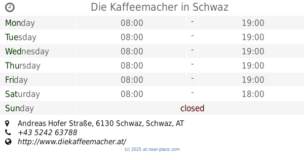
Die Kaffeemacher
10, Andreas Hofer Straße, Schwaz
Cafe
read more
9.108 km
Cafe Luna
Wopfnerstraße 6, Schwaz
Cafe
read more
9.157 km
coffein
Franz-Josef-Straße 1, Schwaz
Cafe
read more
9.17 km
Central Cafe
Fuggergasse 2, Schwaz
Cafe
read more
9.183 km
Cafe Radio
Andreas Hofer Straße 3, Schwaz
Cafe
read more
9.294 km
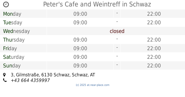
Peter's Cafe and Weintreff
Gilmstraße 3, Schwaz
Cafe
read more
12.88 km
Cafe Pub Boxenstop
Waldeben 3, Weerberg
Cafe
read more
17.368 km
Buffet Bahnhof Fritzens-Wattens
Bahnhofplatz 1, Fritzens
Cafe
read more
18.066 km
Cafe Mozart
Doktor-Karl-Stainer-Straße 4, Wattens
Cafe
read more
18.077 km
KING's Coffee Bar
Wattener Ladenstraße, Doktor-Karl-Stainer-Straße 4, Wattens
Cafe
read more
📑
all categories
Accounting
Administrative area level 1
Administrative area level 2
Airport
Amusement park
Aquarium
Art gallery
Atm
Bakery
Bank
Bar
Beauty salon
Bicycle store
Book store
Bowling alley
Bus station
Cafe
Campground
Car dealer
Car rental
Car repair
Car wash
Casino
Cemetery
Church
City hall
Clothing store
Colloquial area
Convenience store
Country
Courthouse
Dentist
Department store
Doctor
Electrician
Electronics store
Embassy
Finance
Fire station
Florist
Food
Funeral home
Furniture store
Gas station
General contractor
Grocery or supermarket
Gym
Hair care
Hardware store
Health
Hindu Temple
Home goods store
Hospital
Insurance agency
Jewelry store
Laundry
Lawyer
Library
Light rail station
Liquor store
Local government office
Locality
Locksmith
Lodging
Meal delivery
Meal takeaway
Mosque
Movie rental
Movie theater
Moving company
Museum
Natural feature
Neighborhood
Night club
Painter
Park
Parking
Pet store
Pharmacy
Physiotherapist
Place of worship
Plumber
Point of interest
Police
Political
Post office
Premise
Real estate agency
Restaurant
Roofing contractor
Route
Rv park, camping
School
Shoe store
Shopping mall
Spa
Stadium
Storage
Store
Subpremise
Subway station
Supermarket
Synagogue
Taxi stand
Train station
Transit station
Travel agency
University
Veterinary care
Zoo
administrative area level 3
sublocality level 1
↑