Cafe nearby Wiener Rösthaus im Prater
Austria
Cafe nearby Wiener Rösthaus im Prater
Wiener Rösthaus im Prater
Prater 80/2, Wien Österreich
contacts phone
:
+43
Latitude:
48.2144267
, Longitude:
16.4030936
read more
nearest Cafe
229 m
Gösser Eck im Prater
Prater 36, Wien
Cafe
read more
482 m
Zum Konstantineck
Prater, Hauptallee 125b, Wien
Cafe
read more
564 m
Bierbeisl
Stuwerstraße 47, Wien
Cafe
read more
600 m
Mokkathek
Ilgplatz 6, Wien
Cafe
read more
620 m
dezentral
Ilgplatz 5, Wien
Cafe
read more
622 m
B. Jovanovic & Co KEG
Max-Winter-Platz 15, Wien
Cafe
read more
699 m
Cafe Klitzeklein
Ausstellungsstraße 2, Wien
Cafe
read more
783 m
Café Vienna
Engerthstraße 231, Wien
Cafe
read more
785 m
Café at the Park
Max-Winter-Platz 8, Wien
Cafe
read more
795 m
cafe kunst haus
Dampfschiffstraße, Wien
Cafe
read more
803 m
Coffee & Dogs
Trabrennstraße 7, Wien
Cafe
read more
864 m
Kate´s
Wien
Cafe
read more
866 m
Kate´s
Vienna
Cafe
read more
920 m
McDonald's
Praterstern 3990/2, Wien
Cafe
read more
947 m
Restaurant Visconti
Vorgartenstraße 206B, Wien
Cafe
read more
987 m
Cafe Mario
Mayergasse 14, Wien
Cafe
read more
999 m
Il Gelato
オーストリア, Löwengasse 23, Vienna
Cafe
read more
1.018 km
Wittelsbach Cafe
Wittelsbachstraße 2, Wien
Cafe
read more
1.027 km
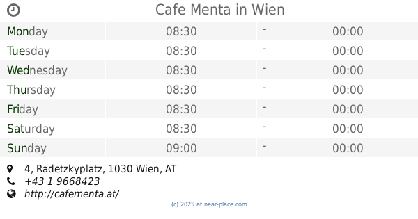
Cafe Menta
Radetzkyplatz 4, Wien
Cafe
read more
1.028 km
Speisen & Getränke
Kegelgasse 33, Wien
Cafe
read more
1.031 km
Ströck
Löwengasse 39, Wien
Cafe
read more
1.036 km
Confiserie zum Prater
Praterstraße 74, Wien
Cafe
read more
1.04 km
Kunst-Café im Hundertwasserhaus
Löwengasse 41-43, Wien
Cafe
read more
1.044 km
Terrassencafe im Hundertwasserhaus
Kegelgasse 36-38, Wien
Cafe
read more
1.161 km
Café Zartl
Rasumofskygasse 7, Wien
Cafe
read more
📑
all categories
Accounting
Administrative area level 1
Administrative area level 2
Airport
Amusement park
Aquarium
Art gallery
Atm
Bakery
Bank
Bar
Beauty salon
Bicycle store
Book store
Bowling alley
Bus station
Cafe
Campground
Car dealer
Car rental
Car repair
Car wash
Casino
Cemetery
Church
City hall
Clothing store
Colloquial area
Convenience store
Country
Courthouse
Dentist
Department store
Doctor
Electrician
Electronics store
Embassy
Finance
Fire station
Florist
Food
Funeral home
Furniture store
Gas station
General contractor
Grocery or supermarket
Gym
Hair care
Hardware store
Health
Hindu Temple
Home goods store
Hospital
Insurance agency
Jewelry store
Laundry
Lawyer
Library
Light rail station
Liquor store
Local government office
Locality
Locksmith
Lodging
Meal delivery
Meal takeaway
Mosque
Movie rental
Movie theater
Moving company
Museum
Natural feature
Neighborhood
Night club
Painter
Park
Parking
Pet store
Pharmacy
Physiotherapist
Place of worship
Plumber
Point of interest
Police
Political
Post office
Premise
Real estate agency
Restaurant
Roofing contractor
Route
Rv park, camping
School
Shoe store
Shopping mall
Spa
Stadium
Storage
Store
Subpremise
Subway station
Supermarket
Synagogue
Taxi stand
Train station
Transit station
Travel agency
University
Veterinary care
Zoo
administrative area level 3
sublocality level 1
↑