Gas station nearby Agrola
Coronavirus disease (COVID-19) Situation
confirmed cases
6081287
deaths
22542
Austria
Gas station nearby Agrola
Agrola
Vorarlbergerstraße 102, Schaanwald Österreich
contacts phone
:
+43
Latitude:
47.2103047
, Longitude:
9.5607461
read more
nearest Gas station
1.052 km
Shell
Vorarlbergerstraße 1, Schaanwald
Gas station
read more
1.578 km
BP
Feldkircher Strasse 2, Nendeln
Gas station
read more
1.73 km
Eni Tankstelle
Liechtensteiner Straße 115, Feldkirch
Gas station
read more
2.584 km
Coop Shop Tankstelle
Essanestrasse 739, Eschen
Gas station
read more
2.592 km
Coop Pronto Eschen FL
Essanestrasse 15, Eschen
Gas station
read more
2.592 km
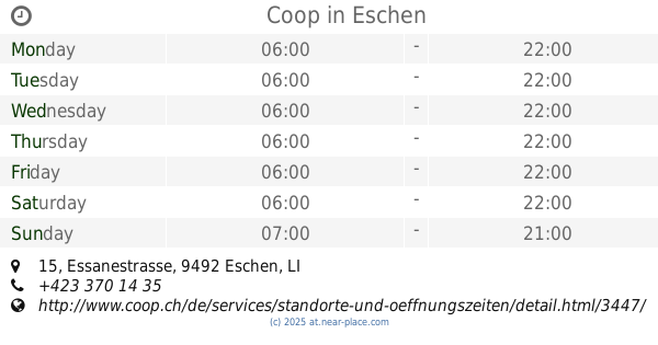
Coop
Essanestrasse 15, Eschen
Gas station
read more
2.988 km
Markus Müller
Liechtensteiner Straße 66, Feldkirch
Gas station
read more
2.988 km
Bauer Tankstellen GmbH
Liechtensteiner Straße 66, Feldkirch
Gas station
read more
2.996 km
Shell
Liechtensteiner Straße 66, Feldkirch
Gas station
read more
4.001 km
Avia petrol station
Eschner Strasse 33
Gas station
read more
4.106 km
BP Tankstelle Ernst Mähr
Hämmerlestraße 99, Feldkirch-Gisingen
Gas station
read more
4.106 km
BP gas station Ernst Mähr
Hämmerlestraße 99, Feldkirch-Gisingen
Gas station
read more
4.126 km
BP
Hämmerlestraße 99, Feldkirch
Gas station
read more
4.407 km
BP
Schaanerstrasse 47
Gas station
read more
4.57 km
OMV Tankstelle
Feldkircher Straße 47, Frastanz
Gas station
read more
4.754 km
Peter Franz Steiner e.U.
Feldkircher Straße 34, Frastanz
Gas station
read more
5.186 km
Agrola
Im Alten Riet 23, Schaan
Gas station
read more
5.45 km
Agrola
Buchserstrasse 2, Sennwald
Gas station
read more
5.494 km
Shell Station
Reichsstraße 137, Feldkirch
Gas station
read more
5.494 km
Shell
Reichsstraße 137, Feldkirch
Gas station
read more
5.565 km
Jet
Reichsstraße 133, Feldkirch
Gas station
read more
5.571 km
JET Tankstelle
Reichsstraße 133 a, Feldkirch
Gas station
read more
5.585 km
Migrol Tankstelle
Feldkircher Strasse 52, Schaan
Gas station
read more
6.444 km
Avia, Im Pardiel 16
Im Pardiel 16, Schaan
Gas station
read more
12.019 km
Freie Tankstelle
Eichaustrasse 8A, Oberriet
Gas station
read more
📑
all categories
Accounting
Administrative area level 1
Administrative area level 2
Airport
Amusement park
Aquarium
Art gallery
Atm
Bakery
Bank
Bar
Beauty salon
Bicycle store
Book store
Bowling alley
Bus station
Cafe
Campground
Car dealer
Car rental
Car repair
Car wash
Casino
Cemetery
Church
City hall
Clothing store
Colloquial area
Convenience store
Country
Courthouse
Dentist
Department store
Doctor
Electrician
Electronics store
Embassy
Finance
Fire station
Florist
Food
Funeral home
Furniture store
Gas station
General contractor
Grocery or supermarket
Gym
Hair care
Hardware store
Health
Hindu Temple
Home goods store
Hospital
Insurance agency
Jewelry store
Laundry
Lawyer
Library
Light rail station
Liquor store
Local government office
Locality
Locksmith
Lodging
Meal delivery
Meal takeaway
Mosque
Movie rental
Movie theater
Moving company
Museum
Natural feature
Neighborhood
Night club
Painter
Park
Parking
Pet store
Pharmacy
Physiotherapist
Place of worship
Plumber
Point of interest
Police
Political
Post office
Premise
Real estate agency
Restaurant
Roofing contractor
Route
Rv park, camping
School
Shoe store
Shopping mall
Spa
Stadium
Storage
Store
Subpremise
Subway station
Supermarket
Synagogue
Taxi stand
Train station
Transit station
Travel agency
University
Veterinary care
Zoo
administrative area level 3
sublocality level 1
↑