Gas station nearby Avia, Im Pardiel 16
Austria
Gas station nearby Avia, Im Pardiel 16
Avia, Im Pardiel 16
Im Pardiel 16, Schaan Austria
contacts phone
:
+43
Latitude:
47.167109
, Longitude:
9.503883
read more
nearest Gas station
604 m
Migrol AG
Feldkircher Strasse 52, Schaan
Gas station
read more
986 m
Migrol Tankstelle
Feldkircher Strasse 52, Schaan
Gas station
read more
1.315 km
Agrola
Im Alten Riet 23, Schaan
Gas station
read more
4.43 km
BP
Schaanerstrasse 47
Gas station
read more
4.829 km
Agrola
Buchserstrasse 2, Sennwald
Gas station
read more
4.85 km
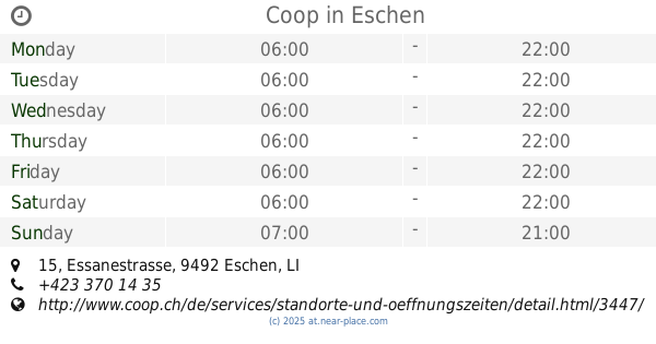
Coop Pronto Eschen FL
Essanestrasse 15, Eschen
Gas station
read more
4.85 km
Coop
Essanestrasse 15, Eschen
Gas station
read more
4.861 km
Coop Shop Tankstelle
Essanestrasse 739, Eschen
Gas station
read more
4.875 km
BP
Feldkircher Strasse 2, Nendeln
Gas station
read more
4.877 km
Avia - Haag
Rheinstrasse 1, Sennwald
Gas station
read more
4.883 km
Kreuz Garage Gebr. Görgin GmbH
Rheinstrasse 1, Haag
Gas station
read more
4.935 km
Avia petrol station
Eschner Strasse 33
Gas station
read more
4.956 km
Coop Pronto Haag Center
Rüti 1, Sennwald
Gas station
read more
4.962 km
Coop Shop Tankstelle
Rüti 1, Haag
Gas station
read more
5.491 km
Shell
Vorarlbergerstraße 1, Schaanwald
Gas station
read more
6.444 km
Agrola
Vorarlbergerstraße 102, Schaanwald
Gas station
read more
9.431 km
Markus Müller
Liechtensteiner Straße 66, Feldkirch
Gas station
read more
10.545 km
BP
Hämmerlestraße 99, Feldkirch
Gas station
read more
11.938 km
Shell Station
Reichsstraße 137, Feldkirch
Gas station
read more
11.938 km
Shell
Reichsstraße 137, Feldkirch
Gas station
read more
13.363 km
Scheier
Egetenweg 52, Feldkirch
Gas station
read more
13.593 km
Hoyer Partner - Scheier Tankstelle A-Feldkirch-Runa
Studa 3a, Feldkirch
Gas station
read more
13.979 km
OMV Tankstelle
Königshofstraße 61, Feldkirch
Gas station
read more
16.386 km
Vinomna Apotheke
Stiegstraße, Rankweil
Gas station
read more
16.68 km
BP Tankstelle Klaudia Lins
Stiegstraße 63, Rankweil
Gas station
read more
📑
all categories
Accounting
Administrative area level 1
Administrative area level 2
Airport
Amusement park
Aquarium
Art gallery
Atm
Bakery
Bank
Bar
Beauty salon
Bicycle store
Book store
Bowling alley
Bus station
Cafe
Campground
Car dealer
Car rental
Car repair
Car wash
Casino
Cemetery
Church
City hall
Clothing store
Colloquial area
Convenience store
Country
Courthouse
Dentist
Department store
Doctor
Electrician
Electronics store
Embassy
Finance
Fire station
Florist
Food
Funeral home
Furniture store
Gas station
General contractor
Grocery or supermarket
Gym
Hair care
Hardware store
Health
Hindu Temple
Home goods store
Hospital
Insurance agency
Jewelry store
Laundry
Lawyer
Library
Light rail station
Liquor store
Local government office
Locality
Locksmith
Lodging
Meal delivery
Meal takeaway
Mosque
Movie rental
Movie theater
Moving company
Museum
Natural feature
Neighborhood
Night club
Painter
Park
Parking
Pet store
Pharmacy
Physiotherapist
Place of worship
Plumber
Point of interest
Police
Political
Post office
Premise
Real estate agency
Restaurant
Roofing contractor
Route
Rv park, camping
School
Shoe store
Shopping mall
Spa
Stadium
Storage
Store
Subpremise
Subway station
Supermarket
Synagogue
Taxi stand
Train station
Transit station
Travel agency
University
Veterinary care
Zoo
administrative area level 3
sublocality level 1
↑